Ebro, Minnesota

Last updated
Ebro
USA Minnesota location map.svg
Red pog.svg
Ebro
Coordinates: 47°29′44″N95°31′46″W / 47.49556°N 95.52944°W / 47.49556; -95.52944 Coordinates: 47°29′44″N95°31′46″W / 47.49556°N 95.52944°W / 47.49556; -95.52944
Country United States
State Minnesota
County Clearwater
Area
[1]
  Total0.88 sq mi (2.27 km2)
  Land0.88 sq mi (2.27 km2)
  Water0.00 sq mi (0.00 km2)
Elevation
1,450 ft (440 m)
Population
 (2020)
  Total50
  Density57.14/sq mi (22.07/km2)
Time zone UTC-6 (Central (CST))
  Summer (DST) UTC-5 (CDT)
Area code 218
GNIS feature ID643146 [2]

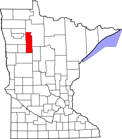
Ebro is a census-designated place and unincorporated community in Falk Township, Clearwater County, Minnesota, United States. Its population was 64 as of the 2010 census. [3]

Contents

Demographics

Historical population
CensusPop.
2020 50
U.S. Decennial Census [4]

History

A post office called Ebro was established in 1898, and remained in operation until it was discontinued in 1975. [5] The community was named after the Ebro River, in Spain. [6]

Related Research Articles

<span class="mw-page-title-main">Wright County, Minnesota</span> County in Minnesota, United States

Wright County is a county in the East Central part of the U.S. state of Minnesota. As of the 2020 census, the population was 141,337. Its county seat is Buffalo. The county was founded in 1855. Wright County is part of the Minneapolis-St. Paul-Bloomington, MN-WI Metropolitan Statistical Area. In terms of population, Wright County is the tenth-largest county in Minnesota and the second-fastest growing.

<span class="mw-page-title-main">Red Lake County, Minnesota</span> County in Minnesota, United States

Red Lake County is a county in the Northwestern part of the U.S. state of Minnesota. As of the 2020 census, the population was 3,935, making it the third-least populous county in Minnesota. Its county seat is Red Lake Falls.

<span class="mw-page-title-main">Mahnomen County, Minnesota</span> County in Minnesota, United States

Mahnomen County is a county in the U.S. state of Minnesota. As of the 2020 census, the population was 5,411. Its county seat is Mahnomen.

<span class="mw-page-title-main">Clearwater County, Minnesota</span> County in Minnesota, United States

Clearwater County is a county in the northwestern part of the U.S. state of Minnesota. As of the 2020 census, the population was 8,524. Its county seat is Bagley.

Jones Township is the southwesternmost township in Beltrami County, Minnesota, United States. The population was 277 as of the 2000 census. Jones Township was named for an early settler.

Lammers Township is a township in Beltrami County, Minnesota, United States. The population was 492 at the 2000 census.

Roosevelt Township is a township in Beltrami County, Minnesota, United States. The population was 219 as of the 2000 census.

<span class="mw-page-title-main">Bagley, Minnesota</span> City in Minnesota, United States

Bagley is a city in Clearwater County, Minnesota, United States. The population was 1,285 at the 2020 census. It is the county seat of Clearwater County.

<span class="mw-page-title-main">Clearbrook, Minnesota</span> City in Minnesota, United States

Clearbrook is a city in Clearwater County, Minnesota, United States. The population was 464 at the 2020 census.

<span class="mw-page-title-main">Gonvick, Minnesota</span> City in Minnesota, United States

Gonvick is a city in Clearwater County, Minnesota, United States. The population was 263 at the 2020 census. Its peak population was 375 in 1950.

<span class="mw-page-title-main">Leonard, Minnesota</span> City in Minnesota, United States

Leonard is a city in Clearwater County, Minnesota, United States. The population was 41 at the 2020 census.

<span class="mw-page-title-main">Shevlin, Minnesota</span> City in Minnesota, United States

Shevlin is a city in Clearwater County, Minnesota, United States. The population was 137 at the 2020 census.

Clearwater Township is a township in Wright County, Minnesota, United States. The population was 1,368 at the 2000 census.

<span class="mw-page-title-main">Clearwater, Minnesota</span> City in Minnesota, United States

Clearwater is a city in Stearns and Wright counties in the U.S. state of Minnesota. The population was 1,735 at the 2010 census. Most of the city lies within Wright County.

<span class="mw-page-title-main">Mallard, Minnesota</span> Ghost town in Minnesota, United States

Mallard is an abandoned townsite in sections 5 and 8 of Itasca Township in Clearwater County, Minnesota, United States. The nearest community is Alida, Minnesota, to the north.

Merrifield is an unincorporated community and census-designated place (CDP) in Lake Edward Township, Crow Wing County, Minnesota, United States, near Brainerd. It is along Crow Wing County Road 3 near County Road 127. Its population was 140 as of the 2010 census.

Silver Creek is an unincorporated community and census-designated place (CDP) in Silver Creek Township, Wright County, Minnesota, United States. As of the 2010 census, its population was 256. The community is on Wright County Road 8 near 112th Street NW. Wright County Road 39 is nearby.

<span class="mw-page-title-main">Fairhaven, Minnesota</span> Unincorporated community in Minnesota, US

Fairhaven is an unincorporated community and census-designated place (CDP) in Fair Haven Township, Stearns County, Minnesota, United States. Its population was 358 as of the 2010 census.

Roy Lake is a census-designated place and unincorporated community in Clearwater and Mahnomen counties, Minnesota, United States. Its population was 12 as of the 2010 census.

South End is a census-designated place in La Prairie Township, Clearwater County, Minnesota, United States. Its population was 25 as of the 2010 census.

References

  1. "2020 U.S. Gazetteer Files". United States Census Bureau. Retrieved July 24, 2022.
  2. "Ebro". Geographic Names Information System . United States Geological Survey, United States Department of the Interior.
  3. "U.S. Census website". United States Census Bureau . Retrieved 2011-05-14.
  4. "Census of Population and Housing". Census.gov. Retrieved June 4, 2016.
  5. "Clearwater County". Jim Forte Postal History. Archived from the original on 27 April 2015. Retrieved 21 April 2015.
  6. Upham, Warren (1920). Minnesota Geographic Names: Their Origin and Historic Significance. Minnesota Historical Society. p.  122.