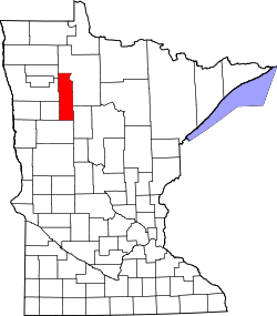
Roy Lake, Minnesota

Last updated

Roy Lake, Minnesota
USA Minnesota location map.svg
Red pog.svg
Roy Lake
Usa edcp location map.svg
Red pog.svg
Roy Lake
Coordinates: 47°19′04″N95°32′34″W / 47.31778°N 95.54278°W / 47.31778; -95.54278
Country United States
State Minnesota
Counties Clearwater, Mahnomen
Townships La Prairie, Twin Lakes
Area
[1]
  Total0.73 sq mi (1.88 km2)
  Land0.45 sq mi (1.16 km2)
  Water0.28 sq mi (0.72 km2)
Elevation
[2]
1,490 ft (450 m)
Population
 (2020) [3]
  Total30
  Density66.82/sq mi (25.81/km2)
Time zone UTC-6 (Central (CST))
  Summer (DST) UTC-5 (CDT)
ZIP Code
56557 (Mahnomen)
Area code 218
GNIS feature ID2583780 [2]
FIPS Code 27-56212

Roy Lake is a census-designated place and unincorporated community in Clearwater and Mahnomen counties, Minnesota, United States. Its population was 30 as of the 2020 census, [3] up from 12 in 2010.

Contents

Geography

The community is mainly in western Clearwater County, in La Prairie Township, but extends west into Mahnomen County, where a small portion is in the northeast corner of Twin Lakes Township. The community sits on the northeast side of Roy Lake, a natural lake with its outlet at the westernmost point of the community. Minnesota State Highway 200 forms the northern edge of the community; the highway leads west 20 miles (32 km) to Mahnomen and east 8 miles (13 km) to Zerkel.

According to the U.S. Census Bureau, the Roy Lake CDP has a total area of 0.73 square miles (1.89 km2), of which 0.45 square miles (1.17 km2) are land and 0.28 square miles (0.73 km2), or 38.2%, are water, comprising the northeast part of Roy Lake. Via the lake's outlet, the community is within the watershed of the Wild Rice River, flowing west toward the Red River of the North.

Demographics

Historical population
CensusPop.Note
2010 12
2020 30150.0%
U.S. Decennial Census [4]

Related Research Articles

<span class="mw-page-title-main">Polk County, Minnesota</span> County in Minnesota, United States

Polk County is a county in the northwestern part of the U.S. state of Minnesota. The population was 31,192 at the 2020 census. Its county seat is Crookston, and the largest community is East Grand Forks.

<span class="mw-page-title-main">Norman County, Minnesota</span> County in Minnesota, United States

Norman County is a county in the northwestern part of the U.S. state of Minnesota. As of the 2020 census, the population was 6,441. Its county seat is Ada. The county is in Minnesota's Red River Valley region.

<span class="mw-page-title-main">Mahnomen County, Minnesota</span> County in Minnesota, United States

Mahnomen County is a county in the U.S. state of Minnesota. As of the 2020 census, the population was 5,411. Its county seat is Mahnomen.

<span class="mw-page-title-main">Clearwater County, Minnesota</span> County in Minnesota, United States

Clearwater County is a county in the northwestern part of the U.S. state of Minnesota. As of the 2020 census, the population was 8,524. Its county seat is Bagley.

Eagle View Township is a township in Becker County, Minnesota, United States. The population was 165 as of the 2000 census.

Round Lake Township is a township in Becker County, Minnesota, United States. The population was 157 as of the 2000 census.

<span class="mw-page-title-main">Mahnomen, Minnesota</span> City in Minnesota, United States

Mahnomen is a city in Mahnomen County, Minnesota, United States, along the Wild Rice River. The population was 1,240 at the 2020 census. It is the seat of Mahnomen County.

<span class="mw-page-title-main">The Lakes, Minnesota</span> Unincorporated community in Minnesota, US

The Lakes is an unincorporated community and census-designated place (CDP) in Murray County, Minnesota, United States located north of Currie and south of Garvin. The population was 590 at the 2020 census. The community is centered about Lake Shetek, the largest lake in southwestern Minnesota. The lake and the community are located in parts of four townships in Murray County: Lake Sarah, Shetek, Murray, and Mason.

Brevator Township is a township in Saint Louis County, Minnesota, United States. The population was 1,269 at the 2010 census.

Cedar Valley Township is a township in Saint Louis County, Minnesota, United States. Cedar Valley Township was named for the white cedar in the valley of the Floodwood River. The population was 195 at the 2010 census.

Naytahwaush is a census-designated place (CDP) in Mahnomen County, Minnesota, United States. The population was 504 at the 2020 census.

<span class="mw-page-title-main">Finland, Minnesota</span> Unincorporated community in Minnesota, US

Finland is an unincorporated community and census-designated place (CDP) in Crystal Bay and Beaver Bay townships, Lake County, Minnesota, United States. As of the 2020 census, its population was 195.

Midway is a census-designated place and unincorporated community in La Garde Township, Mahnomen County, Minnesota, United States. Its population was 20 as of the 2020 census.

Beaulieu is a census-designated place and unincorporated community in Beaulieu and Chief townships, Mahnomen County, Minnesota, United States. Its population was 103 as of the 2020 census.

Pine Bend is a census-designated place and unincorporated community in Island Lake Township, Mahnomen County, Minnesota, United States. Its population was 31 as of the 2020 census.

Riverland is a census-designated place and unincorporated community in Pembina and Marsh Creek townships, Mahnomen County, Minnesota, United States. Its population was 293 at the 2020 census.

The Ranch is a census-designated place in La Garde Township, Mahnomen County, Minnesota, United States. Its population was 14 as of the 2020 census.

Twin Lakes is a census-designated place in the townships of Little Elbow and Twin Lakes, Mahnomen County, Minnesota, United States. Its population was 192 as of the 2020 census, up from 149 in 2010.

West Roy Lake is a census-designated place and unincorporated community in Twin Lakes Township, Mahnomen County, Minnesota, United States. Its population was 56 as of the 2020 census.

Cinnamon Lake is a census-designated place (CDP) within Jackson Township, Ashland County, Ohio, United States. The population was 1,237 at the 2020 census. It consists of a planned community surrounding a 135-acre (0.55 km2) reservoir also named Cinnamon Lake.

References

  1. "2023 U.S. Gazetteer Files: Minnesota". United States Census Bureau. Retrieved January 3, 2024.
  2. 1 2 U.S. Geological Survey Geographic Names Information System: Roy Lake, Minnesota
  3. 1 2 "P1. Race – Roy Lake CDP, Minnesota: 2020 DEC Redistricting Data (PL 94-171)". U.S. Census Bureau. Retrieved January 3, 2024.
  4. "Census of Population and Housing". Census.gov. Retrieved June 4, 2016.