Shevlin, Minnesota

Last updated

Shevlin
Gwaaba'andaawangaakwa'igaang
Clearwater County Minnesota Incorporated and Unincorporated areas Shevlin Highlighted.svg
Location of Shevlin, Minnesota
Coordinates: 47°31′46″N95°15′39″W / 47.52944°N 95.26083°W / 47.52944; -95.26083
CountryUnited States
State Minnesota
County Clearwater
Area
[1]
  Total0.81 sq mi (2.08 km2)
  Land0.81 sq mi (2.08 km2)
  Water0.00 sq mi (0.00 km2)
Elevation
1,453 ft (443 m)
Population
 (2020) [2]
  Total137
  Estimate 
(2021) [3]
138
  Density170.19/sq mi (65.74/km2)
Time zone UTC-6 (CST)
  Summer (DST) UTC-5 (CDT)
ZIP code
56676
Area code 218
FIPS code 27-59782 [4]
GNIS feature ID0659763 [5]

Shevlin is a city in Clearwater County, Minnesota, United States. The population was 137 at the 2020 census. [2]

Contents

History

Shevlin was founded as a logging camp in the late 19th century. The town was named after Thomas H. Shevlin (1852-1912), a lumber baron. [6] Shevlin resides in Clearwater County which seceded from Beltrami County. Shortly after Shevlin made a bid to be the county seat for the new county but the town's folk were defeated in the general election and the county seat went Bagley. Boasting a robust economy the streets of Shevlin were lined with shops, blacksmiths, saloons, hotels, casinos, brothels, and livery stables, a fire claimed most of these buildings in 1904 and again in 1911. Other businesses have made Shevlin their base of operations as well. They include Shevlin cooperative creamery, the locker plant, a saw mill, The co-op oil station, a box factory, several general, hardware and drug stores, three saloons a couple of restaurants, a newspaper, a millinery, barbershop, and doctors' offices. The local Ojibwe needing a name to call this new community in the area started to call Shevlin as Gwaaba'andaawangaakwa'igaang meaning "at where one is shoveling sand" where "shoveling" was a play on words with the City's English name.

Present day

In 1991 the Shevlin School, built in 1911, closed and the students bused to Bagley. [7] A history museum now occupies the old school building. [7] Shevlin today has two churches, two bars, mini storage and numerous other home based enterprises.

Geography

According to the United States Census Bureau, the city has a total area of 0.80 square miles (2.07 km2), all land. [8]

Shevlin is along U.S. Highway 2. It is six miles east of Bagley, and 20 miles west of Bemidji.

Demographics

Historical population
CensusPop.Note
1900 172
1910 1720.0%
1920 1847.0%
1930 22823.9%
1940 226−0.9%
1950 2427.1%
1960 203−16.1%
1970 185−8.9%
1980 1934.3%
1990 157−18.7%
2000 1601.9%
2010 17610.0%
2020 137−22.2%
2021 (est.)138 [3] 0.7%
U.S. Decennial Census [9]
2020 Census [2]

2010 census

As of the census of 2010, there were 176 people, 71 households, and 44 families residing in the city. The population density was 220.0 inhabitants per square mile (84.9/km2). There were 82 housing units at an average density of 102.5 per square mile (39.6/km2). The racial makeup of the city was 89.8% White, 2.3% Native American, 0.6% Pacific Islander, 2.3% from other races, and 5.1% from two or more races. Hispanic or Latino of any race were 2.8% of the population.

There were 71 households, of which 31.0% had children under the age of 18 living with them, 39.4% were married couples living together, 11.3% had a female householder with no husband present, 11.3% had a male householder with no wife present, and 38.0% were non-families. Of all households 32.4% were made up of individuals, and 15.5% had someone living alone who was 65 years of age or older. The average household size was 2.48 and the average family size was 3.20.

The median age in the city was 39 years. 27.3% of residents were under the age of 18; 7.8% were between the ages of 18 and 24; 26.1% were from 25 to 44; 28.9% were from 45 to 64; and 9.7% were 65 years of age or older. The gender makeup of the city was 52.8% male and 47.2% female.

2000 census

As of the census of 2000, there were 160 people, 69 households, and 40 families residing in the city. The population density was 201.1 inhabitants per square mile (77.6/km2). There were 76 housing units at an average density of 95.5 per square mile (36.9/km2). The racial makeup of the city was 96.25% White, 0.62% Native American, and 3.12% from two or more races.

There were 69 households, out of which 33.3% had children under the age of 18 living with them, 46.4% were married couples living together, 4.3% had a female householder with no husband present, and 42.0% were non-families. Of all households 33.3% were made up of individuals, and 10.1% had someone living alone who was 65 years of age or older. The average household size was 2.32 and the average family size was 3.03.

In the city, the population was spread out, with 25.0% under the age of 18, 8.1% from 18 to 24, 31.9% from 25 to 44, 26.9% from 45 to 64, and 8.1% who were 65 years of age or older. The median age was 37 years. For every 100 females, there were 119.2 males. For every 100 females age 18 and over, there were 110.5 males.

The median income for a household in the city was $30,000, and the median income for a family was $37,813. Males had a median income of $23,750 versus $20,000 for females. The per capita income for the city was $20,015. About 6.7% of families and 12.6% of the population were below the poverty line, including 15.6% of those under the age of eighteen and 8.3% of those 65 or over.

Festivals

Shevlin was the home of the Minnesota's Logging Championships held during a festival known as Sawdust Dayz. The competition pitted both amateur and professional loggers against one another in logging events that included log toss, log rolling, axe throw, bow saw, speed cutting, stock saw, standing block chop, two man bucking saw, power saw and the Jack and Jill Crosscut competition. Part of the Sawdust Dayz celebration included parades, bed races, the nickel pick, a variety of kids games, horseshoe competition, and a battle of area fire departments. Sawdust Dayz began in 1987 a project of SCIP (Shevlin Community Improvement Project).

Related Research Articles

<span class="mw-page-title-main">Clearwater County, Minnesota</span> County in Minnesota, United States

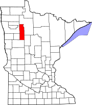
Clearwater County is a county in the northwestern part of the U.S. state of Minnesota. As of the 2020 census, the population was 8,524. Its county seat is Bagley.

<span class="mw-page-title-main">Ramsey, Minnesota</span> City in Minnesota, United States

Ramsey is a suburban city 22 miles (35 km) north-northwest of downtown Minneapolis in Anoka County, Minnesota, United States. The population was 27,646 at the 2020 census. It is a northwest suburb of the Twin Cities.

Forest Township is a township in Becker County, Minnesota, United States. The population was 58 as of the 2000 census.

Alaska Township is a township in Beltrami County, Minnesota, United States. The population was 197 as of the 2000 census. Alaska Township was named by settlers who had recently returned from a trip to Alaska.

Buzzle Township is a township in Beltrami County, Minnesota, United States. The population was 286 as of the 2000 census. Buzzle Township took its name from Buzzle Lake.

Jones Township is the southwesternmost township in Beltrami County, Minnesota, United States. The population was 277 as of the 2000 census. Jones Township was named for an early settler.

Lammers Township is a township in Beltrami County, Minnesota, United States. The population was 492 at the 2000 census.

O'Brien Township is a township in Beltrami County, Minnesota, United States. The population was 56 as of the 2000 census.

Roosevelt Township is a township in Beltrami County, Minnesota, United States. The population was 219 as of the 2000 census.

<span class="mw-page-title-main">Bagley, Minnesota</span> City in Minnesota, United States

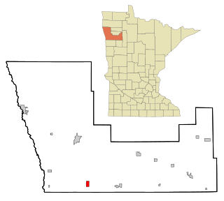
Bagley is a city in Clearwater County, Minnesota, United States. The population was 1,285 at the 2020 census. It is the county seat of Clearwater County.

<span class="mw-page-title-main">Clearbrook, Minnesota</span> City in Minnesota, United States

Clearbrook is a city in Clearwater County, Minnesota, United States. The population was 464 at the 2020 census.

<span class="mw-page-title-main">Gonvick, Minnesota</span> City in Minnesota, United States

Gonvick is a city in Clearwater County, Minnesota, United States. The population was 263 at the 2020 census. Its peak population was 375 in 1950.

<span class="mw-page-title-main">Leonard, Minnesota</span> City in Minnesota, United States

Leonard is a city in Clearwater County, Minnesota, United States. The population was 41 at the 2020 census.

<span class="mw-page-title-main">Rice Lake (CDP), Minnesota</span> Census-designated place in Minnesota, US

Rice Lake is a census-designated place (CDP) in La Prairie Township, Clearwater County, Minnesota, United States, near Lower Rice Lake. The population was 235 at the 2010 census. It is located within ZIP code 56621 based in Bagley.

Shevlin Township is a township in Clearwater County, Minnesota, United States of America. The population was 434 at the 2000 census.

<span class="mw-page-title-main">Watkins, Minnesota</span> City in Minnesota, United States

Watkins is a city in Meeker County, Minnesota, United States. The population was 991 at the 2020 census.

<span class="mw-page-title-main">Beltrami, Minnesota</span> City in Minnesota, United States

Beltrami is a city in Polk County, Minnesota, United States and was named in honor of Giacomo Costantino Beltrami, an Italian exile, who traveled to the Red river and the upper Mississippi in 1823. Officially incorporated on September 11, 1901, there had been settlers in the area since 1870. It is part of the Grand Forks, ND-MN Metropolitan Statistical Area. The population was 88 at the 2020 census.

<span class="mw-page-title-main">Somerville, Texas</span> City in Texas, United States

Somerville is a city in Burleson County, Texas, United States. The population was 1,312 at the 2020 census. Somerville is named for Albert Somerville the first president of the Gulf, Colorado and Santa Fe Railway.

<span class="mw-page-title-main">Clarkston, Washington</span> City in Washington, United States

Clarkston is a city in Asotin County, Washington, United States. It is part of the Lewiston, ID-WA metropolitan area, and is located west of Lewiston, Idaho, across the Snake River.

<span class="mw-page-title-main">Clearwater, Minnesota</span> City in Minnesota, United States

Clearwater is a city in Stearns and Wright counties in the U.S. state of Minnesota. The population was 1,922 at the 2020 census. Most of the city lies within Wright County.

References

  1. "2020 U.S. Gazetteer Files". United States Census Bureau. Retrieved July 24, 2022.
  2. 1 2 3 "Explore Census Data". United States Census Bureau . Retrieved August 21, 2022.
  3. 1 2 "City and Town Population Totals: 2020-2021". United States Census Bureau. August 21, 2022. Retrieved August 21, 2022.
  4. "U.S. Census website". United States Census Bureau . Retrieved January 31, 2008.
  5. "US Board on Geographic Names". United States Geological Survey. October 25, 2007. Retrieved January 31, 2008.
  6. Upham, Warren (1920). Minnesota Geographic Names: Their Origin and Historic Significance. Minnesota Historical Society. p.  123.
  7. 1 2 "Clearwater County- The History Center – Minnesota's Historic Northwest" . Retrieved February 20, 2019.
  8. "US Gazetteer files 2010". United States Census Bureau. Archived from the original on January 25, 2012. Retrieved November 13, 2012.
  9. "Census of Population and Housing". Census.gov. Retrieved June 4, 2015.

47°31′49″N95°15′31″W / 47.53028°N 95.25861°W / 47.53028; -95.25861