Rice Lake (CDP), Minnesota

Last updated

Rice Lake
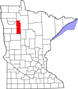
Clearwater County Minnesota Incorporated and Unincorporated areas Rice Lake Highlighted.svg
Location of the census-designated place of Rice Lake
within La Prairie Township, Clearwater County
Coordinates: 47°22′59″N95°30′4″W / 47.38306°N 95.50111°W / 47.38306; -95.50111
Country United States
State Minnesota
County Clearwater
Township La Prairie Township
Area
[1]
  Total10.68 sq mi (27.67 km2)
  Land10.45 sq mi (27.06 km2)
  Water0.24 sq mi (0.62 km2)
Elevation
1,483 ft (452 m)
Population
 (2020)
  Total274
  Density26.23/sq mi (10.13/km2)
Time zone UTC-6 (Central (CST))
  Summer (DST) UTC-5 (CDT)
ZIP code
56621
Area code 218
FIPS code 27-54056 [2]
GNIS feature ID1852584 [3]

Rice Lake is a census-designated place (CDP) in La Prairie Township, Clearwater County, Minnesota, United States, near Lower Rice Lake. The population was 235 at the 2010 census. [4] It is located within ZIP code 56621 based in Bagley.

Contents

Geography

According to the U.S. Census, the CDP has a total area of 10.7 square miles (28 km2), of which, 10.4 square miles (27 km2) is land and 0.2 square miles (0.52 km2) (2.23%) is water.

Demographics

Historical population
CensusPop.Note
2020 274
U.S. Decennial Census [5]

As of the census [2] of 2000, there were 226 people, 61 households, and 53 families residing in the CDP. The population density was 29.4 inhabitants per square mile (11.4/km2). There were 65 housing units at an average density of 8.5/sq mi (3.3/km2). The racial makeup of the CDP was 13.27% White, 84.96% Native American, and 1.77% from two or more races. Hispanic or Latino of any race were 3.54% of the population.

There were 61 households, out of which 42.6% had children under the age of 18 living with them, 42.6% were married couples living together, 18.0% had a female householder with no husband present, and 13.1% were non-families. 1.6% of all households were made up of individuals, and none had someone living alone who was 65 years of age or older. The average household size was 3.70 and the average family size was 3.66.

In the CDP, the population was spread out, with 37.6% under the age of 18, 11.9% from 18 to 24, 22.6% from 25 to 44, 19.9% from 45 to 64, and 8.0% who were 65 years of age or older. The median age was 26 years. For every 100 females, there were 83.7 males. For every 100 females age 18 and over, there were 120.3 males.

The median income for a household is $22,083, and the median income for a family was $22,813. Males had a median income of $17,500 versus $16,875 for females. The per capita income for the CDP was $10,124. About 39.1% of families and 45.9% of the population were below the poverty line, including 63.5% of those under the age of eighteen and 50.0% of those 65 or over.

Related Research Articles

<span class="mw-page-title-main">Blue Ridge, Alabama</span> Census-designated place in Alabama, United States

Blue Ridge is an unincorporated community and census-designated place (CDP) in Elmore County, Alabama, United States. At the 2020 census, the population was 1,485. It is part of the Montgomery Metropolitan Statistical Area.

<span class="mw-page-title-main">Rock Creek, Alabama</span> CDP in Alabama, United States

Rock Creek is a census-designated place in Jefferson County, Alabama, United States. Its location is northwest of Hueytown. At the 2020 census, the population was 1,471. This area was damaged by an F5 tornado on April 8, 1998. An EF2 tornado struck northwest from here on January 23, 2012.

<span class="mw-page-title-main">Underwood-Petersville, Alabama</span> Census-designated place in Alabama, United States

Underwood-Petersville is a census-designated place (CDP) in Lauderdale County, Alabama United States. It is part of the Florence - Muscle Shoals Metropolitan Statistical Area known as "The Shoals". As of the 2010 census, the population of the CDP is 3,247.

<span class="mw-page-title-main">Moores Mill, Alabama</span> Census-designated place in Alabama, United States

Moores Mill is an unincorporated community and census-designated place (CDP) in Madison County, Alabama, United States, and is included in the Huntsville-Decatur Combined Statistical Area. The population was 6,729 at the 2020 census, up from 5,682 at the 2010 census.

<span class="mw-page-title-main">Mignon, Alabama</span> CDP in Alabama, United States

Mignon is a census-designated place (CDP) in Talladega County, Alabama, United States. At the 2020 census, the population was 1,186.

<span class="mw-page-title-main">Fairview, California</span> CDP in California, United States

Fairview is a census-designated place (CDP) in Alameda County, California, United States. It borders on the city of Hayward and the census-designated place of Castro Valley. The population was 11,341 at the 2020 census.

<span class="mw-page-title-main">Bayview-Montalvin, California</span> Former CDP in California, United States

Bayview-Montalvin is a former census-designated place (CDP) in Contra Costa County, California, United States. The population was 5,004 at the 2000 census.

<span class="mw-page-title-main">Lakewood Shores, Illinois</span> Census-designated place in Illinois, United States

Lakewood Shores is a census-designated place (CDP) in Will County, Illinois, United States. The population was 665 at the 2020 census.

<span class="mw-page-title-main">Naval Academy, Maryland</span> Census-designated place in Maryland, United States

Naval Academy is a census-designated place (CDP) in Anne Arundel County, Maryland, United States, which covers the campus of the United States Naval Academy. The population was 4,802 at the 2010 census.

<span class="mw-page-title-main">Oakville, Missouri</span> CDP in Missouri, United States

Oakville is a census-designated place (CDP) in south St. Louis County, Missouri, United States. The population was 36,301 at the 2020 census. Oakville is 18 miles south of the city of St. Louis and borders the Mississippi and Meramec rivers; the area is part of "South County".

<span class="mw-page-title-main">Bunker Hill, Oregon</span> CDP in Oregon, United States

Bunker Hill is a census-designated place (CDP) in Coos County, Oregon, United States. As of the 2010 census the population was 1,444.

<span class="mw-page-title-main">Orchard Hills, Pennsylvania</span> Census-designated place in Pennsylvania, United States

Orchard Hills is a census-designated place (CDP) in Armstrong County, Pennsylvania, United States. The population was 1,949 at the 2020 census.

West Wyomissing is a census-designated place (CDP) in Spring Township, Berks County, Pennsylvania, United States. The population was 3,407 at the 2010 census.

<span class="mw-page-title-main">Plymptonville, Pennsylvania</span> Census-designated place in Pennsylvania, United States

Plymptonville is a census-designated place (CDP) in Clearfield County, Pennsylvania, United States. The population was 972 at the 2020 census.

<span class="mw-page-title-main">Green Valley, South Dakota</span> CDP in South Dakota, United States

Green Valley is a census-designated place (CDP) and unincorporated community in Pennington County, South Dakota, United States. The population was 1,051 at the 2020 census.

Howland is a census-designated place (CDP) in Penobscot County, Maine, United States. The population was 1,096 at the 2010 census.

<span class="mw-page-title-main">Tonawanda (CDP), New York</span> Census-designated place in New York, United States

Tonawanda is a census-designated place (CDP) in Erie County, New York, United States. The CDP comprises the town of Tonawanda minus its subsidiary village of Kenmore. As of the 2010 census, the CDP population was 58,144.

Fryeburg is a census-designated place (CDP) in the town of Fryeburg in Oxford County, Maine, United States. The population was 1,444 at the 2020 census.

Lincoln is a census-designated place (CDP) consisting of the primary settlement in the town of Lincoln in Penobscot County, Maine, United States. The population was 2,884 at the 2010 census.

Machias is a census-designated place (CDP) corresponding to the central village area within the town of Machias in Washington County, Maine, United States. The population of the CDP was 1,274 at the 2010 census.

References

  1. "2020 U.S. Gazetteer Files". United States Census Bureau. Retrieved July 24, 2022.
  2. 1 2 "U.S. Census website". United States Census Bureau . Retrieved January 31, 2008.
  3. "US Board on Geographic Names". United States Geological Survey. October 25, 2007. Retrieved January 31, 2008.
  4. "U.S. Census website". United States Census Bureau . Retrieved May 14, 2011.
  5. "Census of Population and Housing". Census.gov. Retrieved June 4, 2016.