Edgartown (CDP), Massachusetts

Last updated
Edgartown, Massachusetts
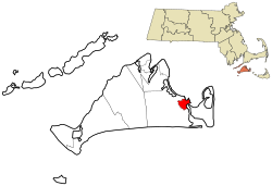
Dukes County Massachusetts incorporated and unincorporated areas Edgartown (CDP) highlighted.svg
Location in Dukes County in Massachusetts
Coordinates: 41°23′22″N70°31′3″W / 41.38944°N 70.51750°W / 41.38944; -70.51750 Coordinates: 41°23′22″N70°31′3″W / 41.38944°N 70.51750°W / 41.38944; -70.51750
Country Flag of the United States.svg  United States
State Massachusetts
County Dukes
Town Edgartown
Area
[1]
  Total1.20 sq mi (3.11 km2)
  Land1.20 sq mi (3.10 km2)
  Water0.01 sq mi (0.01 km2)
Elevation
[2]
17 ft (5 m)
Population
 (2020)
  Total1,107
  Density926.36/sq mi (357.63/km2)
Time zone UTC-5 (Eastern (EST))
  Summer (DST) UTC-4 (EDT)
ZIP Code
02539
Area code(s) 508/774
FIPS code 25-21115
GNIS feature ID2631319 [2]

Edgartown is a census-designated place (CDP) comprising the primary settlement in the town of Edgartown, Dukes County, Massachusetts, United States, on the island of Martha's Vineyard. The CDP also includes the neighborhood of Clevelandtown.

Edgartown was first listed as a CDP after the 2010 census. [2]

Demographics

Historical population
CensusPop.
2020 1,107
U.S. Decennial Census [3]

Related Research Articles

Air Force Academy, Colorado Census Designated Place in State of Colorado, United States

The Air Force Academy is a census-designated place (CDP) located in El Paso County, Colorado, United States. The CDP includes the developed portion of the United States Air Force Academy, including the cadet housing facilities. The CDP is a part of the Colorado Springs, CO Metropolitan Statistical Area. The USAF Academy post office (ZIP Codes 80840 and 80841 serves the area. At the United States Census 2010, the population of the Air Force Academy CDP was 6,680, while the population of the 80840 ZIP Code Tabulation Area was 6,682.

Vineyard Haven, Massachusetts Census-designated place in Massachusetts, United States

Vineyard Haven is a community within the town of Tisbury, Massachusetts on the island of Martha's Vineyard. It is listed as a census-designated place (CDP) by the U.S. Census Bureau with a population of 2,114 as of the 2010 census.

Leola is a census-designated place (CDP) in Lancaster County, Pennsylvania, United States. It includes the unincorporated communities of Leola, Leacock, and Bareville, and prior to 2010 was known as the Leacock-Leola-Bareville census-designated place. Originally named "Mechanicsburg", its present name is a portmanteau of "Leacock" and the "Glenola" train station that once served the town. As of the 2010 census, the population of the CDP was 7,214.

Cheektowaga (CDP), New York Census-designated place in New York, United States

Cheektowaga is a suburban community and census-designated place (CDP) in Erie County, New York, United States. The population was 75,178 at the 2010 census, making it the most populous census-designated place in New York. It is within the town of Cheektowaga. The CDP includes Buffalo Niagara International Airport.

A census-designated place (CDP) is a concentration of population defined by the United States Census Bureau for statistical purposes only. CDPs have been used in each decennial census since 1980 as the counterparts of incorporated places, such as self-governing cities, towns, and villages, for the purposes of gathering and correlating statistical data. CDPs are populated areas that generally include one officially designated but currently unincorporated community, for which the CDP is named, plus surrounding inhabited countryside of varying dimensions and, occasionally, other, smaller unincorporated communities as well. CDPs include small rural communities, edge cities, colonias located along the Mexico–United States border, and unincorporated resort and retirement communities and their environs.

Mashantucket is a census-designated place (CDP) in the northeast part of the town of Ledyard, New London County, Connecticut, United States. It consists of land held by the Mashantucket Pequot Tribe. The Foxwoods Resort Casino is in the northeast part of the CDP, along Connecticut Route 2. As of the 2010 census, the CDP had a population of 299.

Chadds Ford is a census-designated place (CDP) in Delaware and Chester counties, Pennsylvania, United States, comprising the unincorporated communities of Chadds Ford and Chadds Ford Knoll. It was first listed as a CDP prior to the 2020 census.

The United States Census Bureau defines a place as a concentration of population which has a name, is locally recognized, and is not part of any other place. A place typically has a residential nucleus and a closely spaced street pattern, and it frequently includes commercial property and other urban land uses. A place may be an incorporated place or it may be a census-designated place (CDP). Incorporated places are defined by the laws of the states in which they are contained. The Census Bureau delineates CDPs. A small settlement in the open countryside or the densely settled fringe of a large city may not be a place as defined by the Census Bureau. As of the 1990 Census, 26% of the people in the United States lived outside of places.

Dove Valley, Colorado Human settlement in Colorado, United States of America

Dove Valley is an unincorporated community and a census-designated place (CDP) located in and governed by Arapahoe County, Colorado, United States. The CDP is a part of the Denver–Aurora–Lakewood, CO Metropolitan Statistical Area. The population of the Dove Valley CDP was 5,243 at the United States Census 2010. The Dove Valley Metropolitan District provides services to the area, which lies in ZIP code 80112.

Marlboro Meadows, Maryland Census-designated place in Maryland

Marlboro Meadows is an unincorporated community and census-designated place (CDP) in Prince George's County, Maryland, United States. Per the 2020 census, the population was 3,655. It was newly delineated for the 2010 census prior to which the area was part of the Greater Upper Marlboro census-designated place.

Marlboro Village is an unincorporated community and census-designated place (CDP) in Prince George's County, Maryland, United States. Per the 2020 census, the population was 9,221. It was newly delineated for the 2010 census prior to which the area was part of the Greater Upper Marlboro census-designated place.

Summerfield is a census-designated place near Landover in Prince George's County, Maryland, United States. Per the 2020 census, the population was 14,758. It is a suburb of Washington, D.C.

Comobabi is both a census-designated place (CDP) and a populated place in Pima County, Arizona, United States. The population was 8 at the 2010 census. It is located within the Tohono O'odham Indian Reservation.

Murray is a census-designated place (CDP) in the town of Fairfield, Fairfield County, Connecticut, United States. It is in the northern part of Fairfield, with Burr Street running north–south through the center of the CDP. The Merritt Parkway crosses the CDP from east to west, with access from Exit 44 at the eastern edge of the community.

Highland-on-the-Lake, New York Census-designated place in New York, United States

Highland-on-the-Lake is a hamlet and census-designated place (CDP) in the town of Evans, Erie County, New York, United States. It was first listed as a CDP prior to the 2020 census.

Dilworthtown is an unincorporated community and census-designated place (CDP) in Chester and Delaware counties, Pennsylvania, United States. It was first listed as a CDP prior to the 2020 census.

References

  1. "2020 U.S. Gazetteer Files". United States Census Bureau. Retrieved May 21, 2022.
  2. 1 2 3 "Edgartown Census Designated Place". Geographic Names Information System . United States Geological Survey.
  3. "Census of Population and Housing". Census.gov. Retrieved June 4, 2016.