Edgartown (CDP), Massachusetts

Last updated

Edgartown, Massachusetts
Dukes County Massachusetts incorporated and unincorporated areas Edgartown (CDP) highlighted.svg
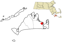
Location in Dukes County in Massachusetts
Coordinates: 41°23′22″N70°31′3″W / 41.38944°N 70.51750°W / 41.38944; -70.51750
Country Flag of the United States (23px).png  United States
State Massachusetts
County Dukes
Town Edgartown
Area
[1]
  Total
1.20 sq mi (3.11 km2)
  Land1.20 sq mi (3.10 km2)
  Water0.01 sq mi (0.01 km2)
Elevation
[2]
16 ft (5 m)
Population
 (2020)
  Total
1,107
  Density926.36/sq mi (357.63/km2)
Time zone UTC-5 (Eastern (EST))
  Summer (DST) UTC-4 (EDT)
ZIP Code
02539
Area codes 508/774
FIPS code 25-21115
GNIS feature ID2631319 [2]

Edgartown is a census-designated place (CDP) comprising the primary settlement in the town of Edgartown, Dukes County, Massachusetts, United States, on the island of Martha's Vineyard. The CDP also includes the neighborhood of Clevelandtown.

Contents

Edgartown was first listed as a CDP after the 2010 census [2] with a population of 1,107 [3]

Demographics

Historical population
CensusPop.Note
2020 1,107
U.S. Decennial Census [4] 2020 [5]

2020 census

Edgartown CDP, Massachusetts – Racial and ethnic composition
Note: the US Census treats Hispanic/Latino as an ethnic category. This table excludes Latinos from the racial categories and assigns them to a separate category. Hispanics/Latinos may be of any race.
Race / Ethnicity (NH = Non-Hispanic)Pop 2020 [5] % 2020
White alone (NH)89180.49%
Black or African American alone (NH)201.81%
Native American or Alaska Native alone (NH)30.27%
Asian alone (NH)100.90%
Native Hawaiian or Pacific Islander alone (NH)10.09%
Other race alone (NH)332.98%
Mixed race or Multiracial (NH)1049.39%
Hispanic or Latino (any race)454.07%
Total1,107100.00%

References

  1. "2020 U.S. Gazetteer Files". United States Census Bureau. Retrieved May 21, 2022.
  2. 1 2 3 "Edgartown Census Designated Place". Geographic Names Information System . United States Geological Survey, United States Department of the Interior.
  3. "Edgartown CDP, Massachusetts". United States Census Bureau . Retrieved September 16, 2022.
  4. "Census of Population and Housing". Census.gov. Retrieved June 4, 2016.
  5. 1 2 "P2 Hispanic or Latino, and Not Hispanic or Latino by Race – 2020: DEC Redistricting Data (PL 94-171) – Edgartown CDP, Massachusetts". United States Census Bureau .