Elm, Cambridgeshire

Last updated

Elm
Allsaintselm.jpg
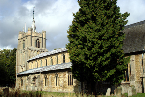
All Saints Church, Elm
Cambridgeshire UK location map.svg
Red pog.svg
Elm
Location within Cambridgeshire
Population3,962 (2011)
OS grid reference TF477062
District
Shire county
Region
Country England
Sovereign state United Kingdom
Post town Wisbech
Postcode district PE14
Dialling code 01945
Police Cambridgeshire
Fire Cambridgeshire
Ambulance East of England
UK Parliament
List of places
UK
England
Cambridgeshire
52°38′N0°11′E / 52.63°N 0.18°E / 52.63; 0.18

Elm is a village and civil parish in the Fenland District of Cambridgeshire, England. In Domesday, it is called Helle. [1]

Contents

The village is about 112 miles or 212 km south of the market town of Wisbech, immediately to the south of the Wisbech by-pass. The county boundary with Norfolk is immediately to the north and north-east. The northern part of Elm village, at Elm Low Road, acts as a suburb of Wisbech. Most of the village straddles the B1101 road, which meanders its way between Wisbech and March.

The civil parish had a resident population of 3,295, as recorded during the 2001 United Kingdom census. The population including Coldham, Collett's Bridge, Friday Bridge and Ring's End was 3,962 at the 2011 Census. [2]

History

Prehistoric

Situated in the Fens, much of the parish would have been undrained salt marsh and salt lagoon, with any higher areas, such as that around Wisbech, forming fen-islands. Mesolithic hunter-gatherers would have fished and hunted waterfowl from these islands. Later, farmers would have grazed their sheep and other livestock on the marsh pastures. Scatters of worked flints have been found at Coldham and other sites. [3]

Roman period

The area was occupied during the Roman period, with domestic finds scattered through the parish, concentrating along the Leam stream, which may have been canalised during the Roman period. [4] Apart from agriculture, there is archaeological evidence of salt processing in the Elm area.[ citation needed ]

Medieval period

The Great Hey or High Fen was common to the vills of Elm, Leverington, Newton, Wisbech, Outwell, Upwell and Tydd St Giles. [5] Drainage and falling sea levels may have prompted the settlement of Elm[ according to whom? ] by the medieval period. In the 13th century the parish was prosperous enough to fund the building of a significant church.[ citation needed ]

Modern period

The lower-lying parts of the parish were probably not fully drained and reclaimed until as recently as the 17th to 19th centuries. Later satellite settlements formed to the south of the parish at Friday Bridge and at Coldham, alongside the Leam, where land was better drained.[ citation needed ]

The Limes, 18th-century farmhouse in Elm, Cambridgeshire Limesofelm.jpg
The Limes, 18th-century farmhouse in Elm, Cambridgeshire

Elm, or Elme, once had a stop on the Wisbech and Upwell Tramway, known as Elmbridge as it was just over the boundary in Norfolk near to a bridge that spanned the former Wisbech Canal.[ citation needed ] There were passenger stations serving the parish: Coldham for Pear Tree Hill, on the March–Wisbech line (1847), and Guyhirn on the March–Spalding line (1867). [6]

The canal connected the River Nene at Wisbech to a junction with the Well Creek and the Old River Nene at Outwell, and passed along the northern edge of Elm. [7] [ failed verification ]

The canal was abandoned, and finally filled in during the 1970s. Parts of it have been converted into a public green lane that starts at the post office, and terminates at the site of Collets Bridge. The tramway that ran alongside the canal was in turn closed to passengers from 1927. [8] It discontinued as a line in 1966. [9]

Besides allotments and market-gardening, a number of apple, pear, and plum orchards have been planted on the better-drained soils close to the village centre in the north of the parish, while the lower-lying peat soils further out are cultivated as high grade arable land. The orchards (some of which have since been replaced by new housing developments) used to attract fruit pickers from London on working holidays. After the Second World War, many of these seasonal visitors would stay at a disused POW camp at Friday Bridge. Today the camp is used mainly by seasonal agricultural workers, including some from abroad. [10]

Thatched farmhouse in the village Elmcottage.jpg
Thatched farmhouse in the village

A stream, known as The Leam, once flowed from March to Wisbech, past the church, and through the village. This stream has now been drained away, and only survives today as a pond to the south of Elm, at Friday Bridge.[ citation needed ] In 2018, Elm parish council ordered the removal of bulrushes from the pond. [11]

Community facilities

Elm's facilities include a primary school, a post office, a local shop, butchers, hairdressers, garages, and two public houses - The Sportsman and the Elm Tree inn. A bus service stops in Elm, running between Wisbech and March. The nearest railway station is at March. National Cycle Network 63 from Wisbech to Burton on Trent, passes directly through the village.

Landmarks

The parish church is a large needle-spired, stone building, mainly of Early English 13th-century origin, and is dedicated to All Saints. The church is a Grade I listed building. [12]

Other notable local buildings include the Grade II listed Elm House, that has been dated to 1630, and the Sportsman public house, two of nearly two dozen listed buildings in the parish. [13]

Notable people

Related Research Articles

<span class="mw-page-title-main">Welney</span> Human settlement in England

Welney is a village and civil parish in the Fens of England, and the county of Norfolk. The village is about 10 miles (16 km) south-west of the town of Downham Market, 20 miles (30 km) south of the town of King's Lynn and 45 miles (70 km) west of the city of Norwich. The county boundary with Cambridgeshire is adjacent, with the city of Cambridge 25 miles (40 km) to the south.

<span class="mw-page-title-main">Wisbech</span> Town and civil parish in Cambridgeshire, England

Wisbech is a market town, inland port and civil parish in the Fenland district in Cambridgeshire, England. In 2011 it had a population of 31,573. The town lies in the far north-east of Cambridgeshire, bordering Norfolk and only 5 miles (8 km) south of Lincolnshire. The tidal River Nene running through the town is spanned by two road bridges. Wisbech is in the Isle of Ely and has been described as 'the Capital of The Fens".

<span class="mw-page-title-main">Fenland District</span> Non-metropolitan district in Cambridgeshire, England

Fenland is a local government district in Cambridgeshire, England. It was historically part of the Isle of Ely and borders the city of Peterborough to the northwest, Huntingdonshire to the west, and East Cambridgeshire to the southeast. It also borders the Lincolnshire district of South Holland to the north and the Norfolk district of King's Lynn and West Norfolk to the northeast. The administrative centre is in March.

<span class="mw-page-title-main">March, Cambridgeshire</span> Town and civil parish in Cambridgeshire, England

March is a Fenland market town and civil parish in the Isle of Ely area of Cambridgeshire, England. It was the county town of the Isle of Ely which was a separate administrative county from 1889 to 1965. The administrative centre of Fenland District Council is located in the town.

Tydd St Giles is a village in Fenland, Cambridgeshire, England. It is the northernmost village in the Isle of Ely, Cambridgeshire, on the same latitude as Midlands towns such as Loughborough, Leicestershire and Shrewsbury, Shropshire. The village is in the distribution area of one local free newspaper, The Fenland Citizen.

<span class="mw-page-title-main">Wisbech Rural District</span>

Wisbech was a rural district in Cambridgeshire in England from 1894 to 1974.

<span class="mw-page-title-main">Parson Drove</span> Human settlement in England

Parson Drove is a fen village in the Isle of Ely, Cambridgeshire, England. A linear settlement, it is 6 miles (10 km) west of Wisbech, the nearest town. The village is named after the central thoroughfare along which the village developed, a green drove, much wider than the current metalled road (B1166). The population at the 2001 Census was 1,030. The population is included in the civil parish of Wisbech St Mary.

<span class="mw-page-title-main">Wisbech and Upwell Tramway</span>

The Wisbech and Upwell Tramway was a rural standard gauge tramway in East Anglia. It was built by the Great Eastern Railway between Wisbech, Isle of Ely, Cambridgeshire and Upwell, now in Norfolk to carry agricultural produce. Although called a tramway, in many ways it more closely resembled a conventional railway line, and paved the way for the passing of the Light Railways Act 1896.

<span class="mw-page-title-main">Middle Level Navigations</span> Waterway network in eastern England

The Middle Level Navigations are a network of waterways in England, primarily used for land drainage, which lie in The Fens between the Rivers Nene and Great Ouse, and between the cities of Peterborough and Cambridge. Most of the area through which they run is at or below sea level, and attempts to protect it from inundation have been carried out since 1480. The Middle Level was given its name by the Dutch Engineer Cornelius Vermuyden in 1642, who subsequently constructed several drainage channels to make the area suitable for agriculture. Water levels were always managed to allow navigation, and Commissioners were established in 1754 to maintain the waterways and collect tolls from commercial traffic.

<span class="mw-page-title-main">Guyhirn</span> Human settlement in England

Guyhirn is a village near the town of Wisbech in Cambridgeshire, England. It is on the northern bank of the River Nene, at the junction of the A141 with the A47. The population is included in the civil parish of Wisbech St Mary. It is notable chiefly for the Chapel of Ease, a rare example of church architecture of the Interregnum (1649–1660), and as a key crossing point of the River Nene.

<span class="mw-page-title-main">Upwell</span> Village in Norfolk, England

Upwell is a village and civil parish in the English county of Norfolk. Upwell village is on the A1101 road, as is Outwell, its conjoined village at the north. The nearest towns are Wisbech to the north-west and Downham Market to the east.

<span class="mw-page-title-main">Wisbech Canal</span> Broad beam canal near Wisbech Cambridgeshire

The Wisbech Canal was a broad canal from Wisbech, Isle of Ely in the Fenland area of Cambridgeshire, England. It ran from the River Nene at Wisbech to the Well Creek at Outwell now in Norfolk, which gave access to the River Great Ouse. It was abandoned in 1926 and filled in during the 1970s.

<span class="mw-page-title-main">Outwell</span> Human settlement in England

Outwell is a village and civil parish in the borough of King's Lynn and West Norfolk, in the English county of Norfolk.

<span class="mw-page-title-main">Nordelph</span> Human settlement in England

Nordelph is a civil parish near Downham Market in the English county of Norfolk.

<span class="mw-page-title-main">Christchurch, Cambridgeshire</span> Human settlement in England

Christchurch is a village in the Fenland district of Cambridgeshire, England. The population of the civil parish at the 2011 Census was 833. The village is sited close to the Cambridgeshire/Norfolk border.

Coldham is a hamlet in Elm civil parish, part of the Fenland district of the Isle of Ely, Cambridgeshire, England. Coldham is the site of a wind farm on a large farm estate of the Cooperative Group near the settlement.

<span class="mw-page-title-main">Friday Bridge, Cambridgeshire</span> Human settlement in England

Friday Bridge is a village in the civil parish of Elm, in the Fenland district of Cambridgeshire, England. It is 3 miles south of Wisbech. In 2021 it had a population of 1412.

Pondersbridge is a village in Whittlesey civil parish, part of the Fenland district of Cambridgeshire, England. Pondersbridge is essentially a settlement which has built up around the river crossing, situated on an artificial drainage cutting called Bevill's Leam. The banks of Bevill's Leam form a strong visual boundary. The older settlement has been extended on the Main Road, north-wards by the local authority housing. The settlement has very limited services and a sporadic development pattern. The main part of Pondersbridge is contained within a triangle of roads - the B1040, the B1095 and The Drove.

<span class="mw-page-title-main">Ring's End</span> Human settlement in England

Ring's End is a hamlet near Guyhirn in the Isle of Ely in Cambridgeshire, England. The population is included in the civil parish of Elm in the district of Fenland.

Geoff Hastings, was an English photographer who worked in Wisbech in the 1950s when the town was being redeveloped. He worked for the Air Inspectorate Department in nearby March, auditing aircraft parts during the Second World War. After the war, he married and worked in Wisbech as a manager with Cambridgeshire Motors on Elm Road. His house was one of many that was affected by the 1978 Wisbech Flood. His collection of thousands of prints was ruined. Fortuitously, the film negatives were not.

References

  1. Frederick J Gardiner (1898). History of Wisbech and Neighborhood, During the Last Fifty Years - 1848-1898. FJ Gardiner & Co. p. 391.
  2. "Civil Parish population 2011". Neighbourhood Statistics. Office for National Statistics. Retrieved 15 July 2016.
  3. "Neolithic". www.archiuk.com. Retrieved 3 December 2019.
  4. "Wisbech, Cambridgeshire". www.archiuk.com. Retrieved 3 December 2019.
  5. "Wisbech manors". www.british-history.ac.uk. Retrieved 14 January 2019.
  6. "Elm". British History. Retrieved 15 May 2022.
  7. "water way routes". www.waterwayroutes. Retrieved 14 January 2019.
  8. "Tramline". www.lner.info. Retrieved 3 December 2019.
  9. "Tramway". www.lner.info//co/GER/wisbech.php. Retrieved 14 January 2019.
  10. "WMS". www.wmsfridaybridgecamp.co.uk. Retrieved 3 December 2019.
  11. "leam pond". www.wisbechstandard.co.uk. Retrieved 14 January 2019.
  12. Historic England. "Church of All Saints, Elm (Grade I) (1331971)". National Heritage List for England . Retrieved 4 January 2019.
  13. "Elm". www.britishlistedbuildings.co.uk. Retrieved 14 January 2019.
  14. F.J.Gardiner (1898). History of Wisbech and Neighbourhood. Gardiner & Co.
  15. "Thomas Aveling". Oxford Dictionary of National Biography (online ed.). Oxford University Press. doi:10.1093/ref:odnb/38436.(Subscription or UK public library membership required.)