
Eugene Airport, also known as Mahlon Sweet Field, is a public airport 7 miles (11 km) northwest of Eugene, in Lane County, Oregon, United States. Owned and operated by the City of Eugene, it is the fifth-largest airport in the Pacific Northwest.

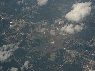
Fort Wayne International Airport lies eight miles southwest of Fort Wayne, in Allen County, Indiana, United States. It is owned by the Fort Wayne-Allen County Airport Authority.

McGhee Tyson Airport is a public/military airport 12 miles (19 km) south of Knoxville, in Alcoa, Tennessee. It is named for United States Navy pilot Charles McGhee Tyson, who was killed in World War I.

McAllen International Airport is in McAllen, in Hidalgo County, Texas, United States.

Ithaca Tompkins International Airport is a county-owned airport located in the Town of Lansing, three miles northeast of Ithaca, the county seat and only city in Tompkins County, New York. The National Plan of Integrated Airport Systems for 2025–2029 categorized it as a primary commercial service facility. Federal Aviation Administration records say the airport had 60,848 passenger boardings in 2023.
Greater Binghamton Airport is a county-owned American airport eight miles north of Binghamton, in Broome County, New York. It is in East Maine, New York and serves the Southern Tier of New York.

Sioux Falls Regional Airport, also known as Joe Foss Field, is a public and military use airport three miles northwest of Sioux Falls, South Dakota, United States. It is named in honor of aviator and Sioux Falls native Joe Foss, who later served as the 20th Governor of South Dakota (1955–1959).

Blue Grass Airport is a public airport in Fayette County, Kentucky, United States, 6 miles west of downtown Lexington. Located among horse farms and situated directly across from Keeneland Race Course, Blue Grass Airport is the primary airport serving central and eastern Kentucky. More than 1.3 million passengers depart or arrive annually at Blue Grass Airport. In 2017, the airport served 1,316,847 passengers via four major airline carriers: Allegiant Air, American Airlines, Delta Air Lines, and United Airlines.
Evansville Regional Airport is three miles north of Evansville, in Vanderburgh County, Indiana, United States. It is owned and operated by the Evansville-Vanderburgh Airport Authority District.

Worcester Regional Airport is three miles (5 km) west of Worcester, in Worcester County, Massachusetts, United States. The main property lies within municipalities of Worcester and Leicester, with supporting facilities in Paxton. Once owned by the City of Worcester, the airport has been owned and operated by the Massachusetts Port Authority (Massport) since June 2010.
Shreveport Regional Airport is a public use airport in Shreveport, Louisiana, United States. It is owned by the City of Shreveport and located four nautical miles (7 km) southwest of its central business district.

Glacier Park International Airport is in Flathead County, Montana, United States, six miles northeast of Kalispell. The airport is owned and operated by the Flathead Municipal Airport Authority, a public agency created by the county in 1974. The airport is near Glacier National Park.

Montgomery Regional Airport is a civil-military airport seven miles southwest of Montgomery, the capital of Alabama. Owned by the Montgomery Airport Authority, it is used for general aviation and military aviation, and sees two airlines.

Charlottesville–Albemarle Airport is an airport eight miles north of Charlottesville, in Albemarle County, Virginia, United States. It opened in 1955 and serves the Central Virginia and Shenandoah Valley region with non-stop flights to five major cities on three airlines' subsidiaries. CHO underwent major construction in summer 2006; an 800-foot runway extension began in summer 2010 and was completed in December 2012.
Fayetteville Regional Airport, also known as Grannis Field, is a public use airport in Cumberland County, North Carolina, United States. It is owned by the city of Fayetteville and located three nautical miles (6 km) south of its central business district.
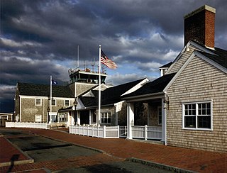
Nantucket Memorial Airport is a public airport on the south side of the island of Nantucket, Massachusetts, United States. It is owned by the Town of Nantucket and is located three miles (5 km) southeast of the town center. It is the second-busiest airport in the state, after Logan International Airport, due to intense corporate travel to and from the island in the high season.

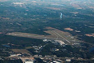
Roanoke–Blacksburg Regional Airport is three miles northwest of downtown Roanoke, Virginia, although still within the independent city's borders. The five-member Roanoke Regional Airport Commission governs it, which includes representatives from the city and county of Roanoke. The airport has two runways and an average of 116 operations a day; it covers 912 acres.

Pellston Regional Airport, also known as Pellston Regional Airport of Emmet County, is a public airport located one mile (1.6 km) northwest of the central business district of Pellston, a village in Emmet County, Michigan, United States. It is included in the Federal Aviation Administration (FAA) National Plan of Integrated Airport Systems for 2017–2021, in which it is categorized as a non-hub primary commercial service facility.

Redmond Municipal Airport is in Deschutes County, Oregon, United States. It is owned and operated by the city of Redmond, Oregon.

St. George Regional Airport is a city-owned airport in St. George, Washington County, Utah.


