| Epol Falls | |
|---|---|
 | |
 | |
| Location | Baganihan, Marilog, Davao City |
| Coordinates | 7°27′13″N125°14′15″E / 7.45361°N 125.23750°E |
Epol Falls is a waterfall in Davao City, Philippines.
| Epol Falls | |
|---|---|
| | |
| | |
| Location | Baganihan, Marilog, Davao City |
| Coordinates | 7°27′13″N125°14′15″E / 7.45361°N 125.23750°E |
Epol Falls is a waterfall in Davao City, Philippines.
Epol is an acronym which stands for Everlasting Power of Love Waterfalls. [1] It was formerly known as the Green Valley waterfalls. It is one of the natural tourist attractions of the mountainous area of Marilog District Davao City which is approximately three hundred (300) meters away from the highway. The falls are cascades of cold water that plunge into a natural pool. It is surrounded by tropical plants and trees that provide a habitat for wildlife.
The Epol falls have bamboo huts that provide shade and a place to prepare food.
Epol Falls is located at the district of Marilog in the mountainous area of barangay Baganihan, the homeland of the Matigsalug tribe and is adjacent to Bukidnon and North Cotabato provinces. It is high altitude with some parts reaching 4,000 feet above sea level, cool and pleasant weather where many go for treks, vegetables and just to escape the humid and punishing heat in the lowlands. [2]
The falls are approximately 80km (50 miles) from downtown Davao City, and almost three hours travel by bus.
According to the Matigsalug tribe ancestor, a long time ago the falls has been the witness of the forbidden relationship of a lover. It was a rendezvous for their secret affair. One day the father of the girl found out about their relationship and took her away to a faraway place. From then on, nobody knows what happened to the girl. Every day the man visited the falls, hopelessly hoping that the girl will come back.
One day when he was very old, he noticed an old woman sitting beside the falls. It was his long-lost girlfriend. They both cried and hug each other and hold on to the Everlasting power of love.
From ancestor to ancestor, this legend had been passed down. One day, a tourist visited the place which was formerly called “Green Valley” – a name after the green background of the falls. After he heard the love story from one of the native guides he exclaimed: "Oh! this place is not a green valley, it is a place of Everlasting power of love. From then on, they called the place Epol.
To reach the Epol waterfalls, there is a hike of 30 minutes on a forest trail. The trail going down to the falls is interesting due to the huge forest trees, rare plants, wildflowers, and colourful butterflies and insects. The trail is usually slippery due to the cold weather condition of the place and it is recommended to wear hiking shoes.
Epol waterfall is maintained and managed by Marilog locals who collect an entrance fee. Marilog locals belong to the Matigsalug tribe.
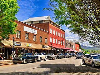
Franklin is a town in and the county seat of Macon County, North Carolina, United States. It is situated within the Nantahala National Forest. The population was reported to be 4,175 in the 2020 census, an increase from the total of 3,845 tabulated in 2010.
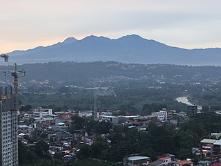
Mount Apo is the highest mountain peak in the Philippines, with a elevation of 2,954 meters (9,692 ft) above sea level. A large solfataric, dormant stratovolcano, it is part of the Apo-Talomo Mountain Range of Mindanao island. Apo is situated on the tripartite border of Davao City, Davao del Sur, and Cotabato; its peak is visible from Davao City 45 kilometers (28 mi) to the northeast, Digos 25 kilometers (16 mi) to the southeast, and Kidapawan 20 kilometers (12 mi) to the west. Apo is a protected area and is the centerpiece of Mount Apo Natural Park.

Sequoia National Park is a national park of the United States in the southern Sierra Nevada east of Visalia, California. The park was established on September 25, 1890, and today protects 404,064 acres of forested mountainous terrain. Encompassing a vertical relief of nearly 13,000 feet (4,000 m), the park contains the highest point in the contiguous United States, Mount Whitney, at 14,505 feet (4,421 m) above sea level. The park is south of, and contiguous with, Kings Canyon National Park; both parks are administered by the National Park Service together as Sequoia and Kings Canyon National Parks. UNESCO designated the areas as Sequoia-Kings Canyon Biosphere Reserve in 1976.

Multnomah Falls is a waterfall located on Multnomah Creek in the Columbia River Gorge, east of Troutdale, between Corbett and Dodson, Oregon, United States. The waterfall is accessible from the Historic Columbia River Highway and Interstate 84. Spanning two tiers on basalt cliffs, it is the tallest waterfall in the state of Oregon at 620 ft (189 m) in height. The Multnomah Creek Bridge, built in 1914, crosses below the falls, and is listed on the National Register of Historic Places.

Jiuzhaigou is a nature reserve and national park located in the north of Sichuan Province in southwestern China.The southern end is the Minshan Garna Peak, and the northern end is the Huanglong Scenic Area. It originates from the Baishui River area, one of the headwaters of the Jialing River and a part of the Yangtze River system. A long valley running north to south, Jiuzhaigou was inscribed by UNESCO as a World Heritage Site in 1992 and a World Biosphere Reserve in 1997. It belongs to the category V in the IUCN system of protected area categorization.

Ricketts Glen State Park is a Pennsylvania state park on 13,193 acres (5,280 ha) in Columbia, Luzerne, and Sullivan counties in Pennsylvania in the United States. Ricketts Glen is a National Natural Landmark known for its old-growth forest and 24 named waterfalls along Kitchen Creek, which flows down the Allegheny Front escarpment from the Allegheny Plateau to the Ridge-and-Valley Appalachians. The park is near the borough of Benton on Pennsylvania Route 118 and Pennsylvania Route 487, and is in five townships: Sugarloaf in Columbia County, Fairmount and Ross in Luzerne County, and Colley and Davidson in Sullivan County.

Mbeya is a city located in south west Tanzania, Africa, with an urban population of 649,000 in 2023. Mbeya is the capital of the surrounding rural Mbeya region.

Hogsback is a village in the Amathole Mountains in the Eastern Cape Province, South Africa.

Thalaiyar Falls"prohibited Water falls by Theni forest division", also known as Rat Tail Falls is a waterfall Located in the Theni District, which flows as Manjalar River, one of the tributaries of Vaigai river which flows in the south of Tamil Nadu State, South India. It is 297 m (974 ft) tall and is the highest waterfall in Tamil Nadu, the Sixth highest waterfall in India and the 267th highest in the world.

The Giant Mountains, Krkonoše, or Karkonosze, are a mountain range located in the north of the Czech Republic and the south-west of Poland, part of the Sudetes mountain system. The Czech–Polish border, which divides the historic regions of Bohemia and Silesia, runs along the main ridge. The highest peak, Sněžka, is the Czech Republic's highest natural point with an elevation of 1,603 metres (5,259 ft).

The Paugussett Trail is a 14-mile (23 km) Blue-Blazed hiking trail "system" in the lower Housatonic River valley in Fairfield County and, today, is entirely in Shelton and Monroe, Connecticut. Much of the trail is in Indian Well State Park and the Town of Monroe's Webb Mountain Park. The mainline trail is primarily southeast to northwest with three short side or spur trails.
The Lillinonah Trail is a 5.9-mile (9.5 km) Blue-Blazed hiking trail "system" in the lower Housatonic River valley in Fairfield County and, today, is entirely in Newtown. Most of the trail is in the upper block of Paugussett State Forest.
Avatime Vane is the capital of the Avatime Traditional Area. It is located on the Eastern section of the Akuapem-Togo ranges, an ancient volcanic mountain formation that rises from the lower Volta basin and runs in a North-Easterly direction into Togo Republic. Vane is located on the main Ho-Fume road and is the first settlement located on highlands North East of Dzolokpuita Vane is where the Osie or overlord of Avatime resides.

The Narragansett Trail is a 16 miles (26 km) hiking trail located in Connecticut. It is one of the Blue-Blazed Trails maintained by the Connecticut Forest and Park Association, the Narragansett Council, and the Rhode Island chapter of Scouts BSA.

The Fiery Gizzard Trail runs from Tracy City, Tennessee to Foster Falls in Marion County, Tennessee. It is renowned for its beauty and diversity, cited by Backpacker magazine as one of the top 25 hiking trails in the United States. The 12.5-mile (20.1 km) trail offers scenic views, waterfalls, rock formations, and hemlock trees over 200 years old.

Davao Occidental, officially the Province of Davao Occidental, is a province in the Philippines located in the Davao Region in Mindanao. Its capital is the municipality of Malita, the most populous town in the province. To the east lies Davao Gulf. It also shares a maritime border with the Indonesian province of North Sulawesi to the south.

The Bridal Veil Falls is six kilometres outside Sabie, Mpumalanga in South Africa. It is 70 metres high. The falls is slow flowing under normal conditions making it appear like a veil, hence its name. It is one of many waterfalls in the area that is located on the Sabie River and is a popular tourist destination. It is accessible by car, with parking and a picnic area on SAFCOL's grounds.From the car park, a footpath runs through indigenous forest for about 750 metres directly to the waterfall.
Kotla is the name of a valley in Northern Bagh the name of the main village of this valley is Kotla,on the basis of which the entire valley was named Kotla Valley. Kotla is a Village and tourist resort in Bagh District, Azad Kashmir, Pakistan. Kotla is 6,560 feet (2,000 m) above sea level. Kotla contains pine trees that are hundreds of years old. It takes approximately 1 hour to drive from Bagh to Kotla.

Mānoa Falls Trail is a 1.6-mile (2.6 km) trail on the island of Oahu in Hawaii. The trail is a part of the Honolulu Makau Trail System, and leads to a popular 150 foot waterfall called Manoa Falls. Hiking the trail is approximately a one-hour round trip. Many tourists are attracted to the waterfall and scenery throughout the trail. The trails have a history as one of the earlier Hawaiian trails. There are many legends of the Night Marchers, or ancient Hawaiian warriors associated with Manoa Falls. Scenes in movies such as Jurassic Park and Catching Fire were filmed at Manoa Falls. The Manoa Falls trail harbors many plant species and tropical birds as well. The Lyon Arboretum, located in the Manoa Valley at the base of the trail is another popular tourist attraction and aims to preserve endangered Hawaiian plants. Some may say that this trail is "Easy". However, there is currently no formal way of rating trails. Therefore, since the trail can be very slippery when wet the rating can be subjective. Thus, users should use caution on any trail and turn around if not comfortable. Rain showers are very common on the trail and the path to the waterfall is often muddy and slippery. Flash floods may also occur at any time. Swimming in the pools of water on the trail is highly discouraged due to the threat of Leptospirosis.

Caledonia Waterfalls or Kalidonia Waterfalls, is the Latin name given to the waterfalls discovered by a Scottish expedition visiting the Platres region of Cyprus in 1878. They were surprised by the resemblance of the waterfall with their homeland and named them Caledonia which is an ancient Latin name of Scotland.
| Geography |  | |
|---|---|---|
| History | ||
| Government | ||
| Public services and utilities | ||
| Landmarks | ||
| Education | ||
| Culture | ||
| Transportation | ||