
A port is a maritime facility comprising one or more wharves or loading areas, where ships load and discharge cargo and passengers. Although usually situated on a sea coast or estuary, ports can also be found far inland, such as Hamburg, Manchester and Duluth; these access the sea via rivers or canals. Because of their roles as ports of entry for immigrants as well as soldiers in wartime, many port cities have experienced dramatic multi-ethnic and multicultural changes throughout their histories.

Davao Region, formerly called Southern Mindanao, is an administrative region in the Philippines, designated as Region XI. It is situated at the southeastern portion of Mindanao and comprises five provinces: Davao de Oro, Davao del Norte, Davao del Sur, Davao Oriental, and Davao Occidental.

Davao Oriental, officially the Province of Davao Oriental, is a province in the Philippines located in the Davao Region in Mindanao. Its capital is the city of Mati which is the most populous, and it borders the province of Davao de Oro to the west, and Agusan del Sur and Surigao del Sur to the north. The province is the traditional homeland of the Mandaya and Kalagan/Kaagan.

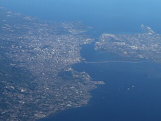
Davao City, officially the City of Davao, is a highly urbanized city in the Davao Region, Philippines. The city has a total land area of 2,443.61 km2 (943.48 sq mi), making it the largest city in the Philippines in terms of land area. It is the third-most populous city in the Philippines after Quezon City and Manila respectively, and the most populous city in Mindanao, in Davao Region, and outside of Metro Manila. According to the 2020 census, it has a population of 1,776,949 people.

Francisco Bangoy International Airport, also commonly known as Davao International Airport, is the main airport serving Davao City and Davao Region in the Philippines. Serving as the main gateway to Mindanao, it is the busiest airport on the island and the third busiest in the Philippines in 2022.

The Port of Hong Kong located by the South China Sea, is a deepwater seaport dominated by trade in containerised manufactured products, and to a lesser extent raw materials and passengers. A key factor in the economic development of Hong Kong, the natural shelter and deep waters of Victoria Harbour provide ideal conditions for berthing and the handling of all types of vessels. It is one of the busiest ports in the world, in the three categories of shipping movements, cargo handled and passengers carried. This makes Hong Kong a Large-Port Metropolis.

Samal, officially the Island Garden City of Samal is a 4th class component city in the province of Davao del Norte, Philippines. According to the 2020 census, it has a population of 116,771 people.
Ports North, the trading name of the Far North Queensland Ports Corporation Limited, is a Queensland Government statutory corporation that is responsible for the Cairns Marlin Marina and the Cairns Cityport project and the ports in Cairns, Cape Flattery, Karumba, Mourilyan, Skardon River, Quintell Beach, Thursday Island, Burketown and Cooktown, in Queensland, Australia. Since 2023, the shareholding Ministers are the Deputy Premier, Treasurer and Minister for Transport and Main Roads.

The Port of Halifax comprises various port facilities in Halifax Harbour in Halifax, Nova Scotia, Canada. It covers 10 km2 (3.9 sq mi) of land, and looks after 150 km2 (58 sq mi) of water.

The Port of Savannah is a major U.S. seaport located at Savannah, Georgia. As of 2021, the port was the third busiest seaport in the United States. Its facilities for oceangoing vessels line both sides of the Savannah River and are approximately 18 miles (29 km) from the Atlantic Ocean. Operated by the Georgia Ports Authority (GPA), the Port of Savannah competes primarily with the Port of Charleston in Charleston, South Carolina to the northeast, and the Port of Jacksonville in Jacksonville, Florida to the south. The GPA operates one other Atlantic seaport in Georgia, the Port of Brunswick. The state also manages three interior ports linked to the Gulf of Mexico: Port Bainbridge, Port Columbus, and a facility at Cordele, Georgia linked by rail to the Port of Savannah. In the 1950s, the Port of Savannah was the only facility to see an increase in trade while the country experienced a decline in trade of 5%. It was chaired and led by engineer Dr. Blake Van Leer.
Metropolitan Cebu, or simply Metro Cebu,, is the main urban center of the province of Cebu in the Philippines. Metro Cebu is located along the central eastern portion of the island including the nearby island of Mactan. It accounts for 19.9 percent of the land area and 61.5 percent of the population of the entire province of Cebu.
International Container Terminal Services, Inc. (ICTSI) is a global port management company headquartered in Manila, Philippines. Established in 1916, ICTSI is the Philippines' largest multinational and transnational company, having established operations in both developed and emerging market economies in Asia Pacific, the Americas, and Europe, the Middle East and Africa. The company is ranked the eighth largest container terminal operator, according to TEU equity volume.

The Port of Manila refers to the collective facilities and terminals that process maritime trade function in harbors in Metro Manila. Located in the Port Area and Tondo districts of Manila, facing Manila Bay, it is the largest and the premier international shipping gateway to the country. The Philippine Ports Authority, a government-owned corporation, manages the Port of Manila and most of the public ports in the country. It is composed of 3 major facilities, namely Manila North Harbor, Manila South Harbor, and the Manila International Container Terminal.

The Port of Subic Bay is in the Subic Bay Freeport Zone, the former U.S. Naval Base Subic Bay, on Subic Bay in the Philippines. It is one of the busiest, largest, historical and most important of ports in the Philippines. The Port is operated and managed by the Subic Bay Metropolitan Authority (SBMA).

The Port of Iloilo is a seaport located in Iloilo City, Philippines. It serves the city, province of Iloilo, and the entire island of Panay in the Western Visayas region of the Philippines. It is located in the districts of Iloilo City Proper and Lapuz, on the southeastern coast of Panay, in Iloilo Strait, and one of the country’s safest and most natural harbors.
Metro Davao, officially Metropolitan Davao, is a metropolitan area in Mindanao, Philippines. It includes the cities of Davao, Digos, Mati, Panabo, Samal and Tagum and spanned parts of all five provinces of the Davao Region. Metro Davao is one of three metropolitan areas in the Philippines. It is administered by the Metropolitan Davao Development Authority. It is the largest metropolitan region by land area and the second most populous in the Philippines.
Metropolitan Cagayan de Oro, also known as Metro Cagayan de Oro, is the fourth largest metropolitan area in the Philippines. It is located on the northern coast of Mindanao, and comprises the two chartered cities of Cagayan de Oro and El Salvador and the fourteen municipalities of Misamis Oriental which are Alubijid, Balingasag, Claveria, Gitagum, Initao, Jasaan, Laguindingan, Libertad, Lugait, Manticao, Naawan, Opol, Tagoloan, and Villanueva and the six municipalities of Bukidnon which are Manolo Fortich, Baungon, Libona, Malitbog, Sumilao and Talakag. According to the 2015 Philippine census, Metro Cagayan de Oro has a population of 1,687,159 people.

The Batangas International Port or locally known as the Batangas Pier is a seaport in Barangay Santa Clara, Batangas City primarily serving the Calabarzon region of the Philippines. The seaport covers an area of about 150 hectares.

The Port of Penang is a deepwater seaport within the Malaysian state of Penang. It consists of terminals along the Penang Strait, including five in Seberang Perai and one in George Town. The Port of Penang was the third busiest harbour in Malaysia in terms of cargo as of 2017, handling 1.52 million TEUs of cargo, as well as the busiest port-of-call within the country for cruise shipping.

The Port of General Santos, also known as the Makar Port, is a seaport in General Santos in the Philippines.


