Related Research Articles

Malayalam is a Dravidian language spoken in the Indian state of Kerala and the union territories of Lakshadweep and Puducherry by the Malayali people. It is one of 22 scheduled languages of India. Malayalam was designated a "Classical Language of India" in 2013. Malayalam has official language status in Kerala and Puducherry (Mahé), and is also the primary spoken language of Lakshadweep and is spoken by 34 million people in India. Malayalam is also spoken by linguistic minorities in the neighbouring states; with a significant number of speakers in the Kodagu and Dakshina Kannada districts of Karnataka, and Kanyakumari and Nilgiris district of Tamil Nadu. It is also spoken by the Malayali Diaspora worldwide, especially in the Persian Gulf countries, due to the large populations of Malayali expatriates there. They are a significant population in each city in India including Mumbai, Bengaluru, Delhi, Kolkata, Pune etc.
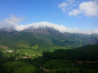
The Western Ghats, also known as the Sahyadri mountain range, is a mountain range that covers an area of 160,000 km2 (62,000 sq mi) in a stretch of 1,600 km (990 mi) parallel to the western coast of the Indian peninsula, traversing the states of Gujarat, Maharashtra, Goa, Karnataka, Kerala and Tamil Nadu. It is a UNESCO World Heritage Site and is one of the 36 biodiversity hotspots in the world. It is sometimes called the Great Escarpment of India. It contains a very large proportion of the country's flora and fauna, many of which are endemic to this region. The Western Ghats are older than the Himalayas. They influence Indian monsoon weather patterns by intercepting the rain-laden monsoon winds that sweep in from the south-west during late summer. The range runs north to south along the western edge of the Deccan Plateau and separates the plateau from a narrow coastal plain called the Western Coastal Plains along the Arabian Sea. A total of 39 areas in the Western Ghats, including national parks, wildlife sanctuaries and reserve forests, were designated as world heritage sites in 2012 – twenty in Kerala, ten in Karnataka, six in Tamil Nadu and four in Maharashtra.

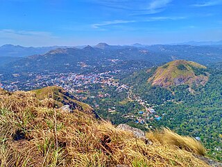
Wayanad is a district in the north-east of the Indian state of Kerala, with administrative headquarters at the municipality of Kalpetta. It is the only plateau in Kerala. The Wayanad Plateau forms a continuation of the Mysore Plateau, the southern portion of Deccan Plateau which links the Western Ghats with the Eastern Ghats. It is set high in the Western Ghats with altitudes ranging from 700 to 2100 meters. Vellari Mala, a 2,240 m (7,349 ft) high peak situated on the trijunction of Wayanad, Malappuram, and Kozhikode districts, is the highest point in Wayanad district. The district was formed on 1 November 1980 as the 12th district in Kerala, by carving out areas from Kozhikode and Kannur districts. An area of 885.92 km2 of the district is forested. Wayanad has three municipal towns—Kalpetta, Mananthavady and Sulthan Bathery. There are many indigenous tribes in this area. The Kabini River, a tributary of Kaveri River, originates at Wayanad. Wayanad district, along with the Chaliyar valley in neighbouring Nilambur in Malappuram district, is known for natural gold fields, which are also seen in other parts of the Nilgiri Biosphere Reserve. Chaliyar river, which is the fourth longest river of Kerala, originates on the Wayanad plateau. The historically important Edakkal Caves are located in Wayanad district.

The Nilgiris district is one of the 38 districts in the southern Indian state of Tamil Nadu. Nilgiri is the name given to a range of mountains spread across the borders among the states of Tamil Nadu, Karnataka and Kerala. The Nilgiri Hills are part of a larger mountain chain known as the Western Ghats. Their highest point is the mountain of Doddabetta, height 2,637 m. The district is contained mainly within the Nilgiri Mountains range. The administrative headquarters is located at Ooty. The district is bounded by Malappuram district of Kerala to the west, Coimbatore and Palakkad to the south, Erode to the east, and Chamarajnagar district of Karnataka and Wayanad district of Kerala to the north. As it is located at the junction of three states, namely, Tamil Nadu, Kerala, and Karnataka, significant Malayali and Kannadiga populations reside in the district. Nilgiris district is known for natural mines of Gold, which is also seen in the other parts of Nilgiri Biosphere Reserve extended in the neighbouring states of Karnataka and Kerala too.

Idukki (ഇടുക്കി), IPA: [iɖukːi], is one of the 14 districts in the Indian state of Kerala. Idukki district lies amid the Cardamom Hills of Western Ghats in Kerala. Idukki district contains two municipal towns - Kattappana and Thodupuzha. The district currently includes five taluks in it.
The Tamil languages are the group of Dravidian languages most closely related to Tamil. In addition to Tamil itself, they are Irula, Betta Kurumba, Yerukala, Eravallan, Kanikkaran, Muthuvan, Sholaga, Kaikadi, and Sankethi.

The Anamala or Anaimalai, also known as the Elephant Mountains, are a range of mountains in the southern Western Ghats of central Kerala and span the border of western Tamil Nadu in Southern India. The name anamala is derived from the Malayalam word aana and the Tamil word yaanai, meaning elephant, or from tribal languages. Mala or Malai means 'mountain', and thus literally translatable as 'Elephant mountain'.
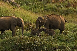
Anaimalai Tiger Reserve, earlier known as Indira Gandhi Wildlife Sanctuary and National Park and as Anaimalai Wildlife Sanctuary, is a protected area in the Anaimalai Hills of Pollachi and Valparai taluks of Coimbatore District and Udumalaipettai taluk in Tiruppur District, Tamil Nadu, India. The Tamil Nadu Environment and Forests Department by a notification dated 27 June 2007, declared an extent of 958.59 km2 that encompassed the erstwhile IGWLS&NP or Anaimalai Wildlife Sanctuary, as Anaimalai Tiger Reserve under the Wildlife Protection Act, 1972. According to the National Tiger Conservation Authority, the Reserve presently includes a core area of 958.59 km2 and buffer/peripheral area of 521.28 km2 forming a total area of 1479.87 km2.
Irula is a Dravidian language spoken by the Irulas who inhabit the area of the Nilgiri mountains, in the states of Tamil Nadu, Kerala, and Karnataka, India. It is closely related to Tamil. It is written in the Tamil script.

Attappady (HQ:Agali) is a tribal taluk in Kerala state covering an area of 735 km2 (284 sq mi). It is carved out from Mannarkkad taluk in Palakkad district on February 2021. Attappady Reserve Forest is a protected area comprising 249 km2 of land area in the western parts of Attappady. It is one among the reserved forests and protected forests of India. Attappadi valley in Palakkad district along with the neighbouring Chaliyar valley of the Nilambur region in Malappuram district is known for natural Gold fields which are also seen in the other regions of Nilgiri Biosphere Reserve.
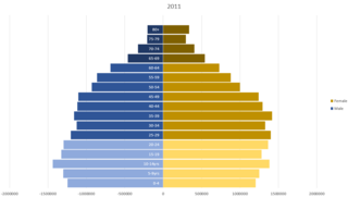
Kerala is a state in south-western India. Most of Kerala's 34.8 million people are ethnically Malayalis. Most of the Malayalam and English speaking Keralites derive their ancestry from Dravidian communities that settled in Kerala. Additional ancestries derive from millennia of trade links across the Arabian Sea, whereby people of Arab, Jewish, Syrian, Portuguese, English and other ethnicities settled in Kerala. Many of these immigrants intermarried with native Malayalam speakers resulting in formation of many Muslims and Christians in Kerala. Some Muslims and Christians thus take lineage from Middle Eastern and European settlers mixed with local population.

Devikulam is a Grama Panchayat and small hill station of about 8 kilometres (5.0 mi) from Munnar in the Idukki District of Kerala State, India. It lies 1,800 metres (5,900 ft) above sea level.
Kattappana is a municipal town in the Sahyadri of Kerala state, India. It is the main urban centre in the high ranges of Idukki district, situated about 2,788.71–2,952.76 feet (850.00–900.00 m) from sea level. It is the second city to become a municipality in Idukki District. It is a major commercial town and flourished with the boost in production of agriculture and spices.
The Agasthyamala Biosphere Reserve is a biosphere reserve in India established in 2001, located in the southernmost end of the Western Ghats and includes 3,500.36 km2 (1,351.50 sq mi) of which 1828 km2 is in Kerala and 1672.36 km2 is in Tamil Nadu. It encompasses the following wildlife sanctuaries: Shendurney Wildlife Sanctuary, Peppara Wildlife Sanctuary, Neyyar Wildlife Sanctuary, and Kalakkad Mundanthurai Tiger Reserve.

Chinnar Wildlife Sanctuary is located 18 km north of Marayoor on State Highway 17 in the Marayoor and Kanthalloor panchayats of Devikulam taluk in the Idukki district of Kerala state in South India. It is one of 18 wildlife sanctuaries among the protected areas of Kerala.
The Pachaimalai Hills,, also known as the Pachais, are a low mountain range in the Eastern Ghats System. They are located in Tiruchirapalli district of Tamil Nadu state, southeastern India. It is situated at a distance of 73 km from Trichy and 112 km from Salem. The Tamil Nadu Government is planning to develop the Pachaimalai as a tourist destination.

Madhuca longifolia is an Indian tropical tree found largely in the central, southern, north Indian plains and forests, Nepal, Myanmar and Sri Lanka. It is commonly known as madhūka, madkam, mahuwa, Butter Tree, mahua, mahwa, mohulo, Iluppai, Mee or vippa chettu. It is a fast-growing tree that grows to approximately 20 meters in height, possesses evergreen or semi-evergreen foliage, and belongs to the family Sapotaceae. It is adaptable to arid environments, being a prominent tree in tropical mixed deciduous forests in India in the states of Odisha, Chhattisgarh, Jharkhand, Uttar Pradesh, Bihar, Maharashtra, Andhra Pradesh, Madhya Pradesh, Kerala, Gujarat, West Bengal and Tamil Nadu.

In India, a Community development block or simply Block is a sub-division of Tehsil, administratively earmarked for planning and development. In tribal areas, similar sub-divisions are called tribal development blocks. The area is administered by a Block Development Officer (BDO), supported by several technical specialists and village-level workers. A community development block covers several gram panchayats, the local administrative units at the village level.

Tribals in Kerala are the tribal population found in the Indian state of Kerala. Most of the tribals of Kerala live in the forests and mountains of Western Ghats, bordering Karnataka and Tamil Nadu.
The Eravallan are Adivasi, a designated Scheduled Tribe in the Indian state of Kerala. They are an aboriginal tribe whose traditional way of life has been based on hunting and gathering.
References
- ↑ Eravallan at Ethnologue (18th ed., 2015) (subscription required)
- ↑ http://egyankosh.ac.in/bitstream/123456789/39135/1/Unit-3.pdf [ bare URL PDF ]
- ↑ "Tribal Communities of Kerala". 18 December 2014.
| | This Dravidian languages-related article is a stub. You can help Wikipedia by expanding it. |