Evans Landing, Queensland

Last updated

Evans Landing
Queensland
Australia Queensland location map.svg
Red pog.svg
Evans Landing
Coordinates 12°39′42″S141°51′13″E / 12.6618°S 141.8536°E / -12.6618; 141.8536 (Evans Landing (centre of locality))
Population56 (2021 census) [1]
 • Density56/km2 (145/sq mi)
Postcode(s) 4874
Area1.0 km2 (0.4 sq mi)
Time zone AEST (UTC+10:00)
LGA(s) Weipa Town
State electorate(s) Cook
Federal division(s) Leichhardt
Suburbs around Evans Landing:
Mission River Mission River Nanum
Mission River Evans Landing Mission River
Albatross Bay Albatross Bay Albatross Bay

Evans Landing is a rural locality in the Weipa Town, Queensland, Australia. [2] In the 2021 census, Evans Landing had a population of 56 people. [1]

Contents

Geography

Albatross Bay ( 8°33′42″S95°34′42″E / 8.5616°S 95.5783°E / -8.5616; 95.5783 (Albatross Bay) ) bounds the locality to the south. [3]

Approximately half of the land at Evans Landing is used for industrial purposes while the remainder is undeveloped. [4]

History

The locality is named after geologist Harry Evans, who found the bauxite deposits in the Weipa area for Consolidated Zinc Corporation. [2]

Demographics

In the 2016 census Evans Landing had a population of 62 people. [5]

In the 2021 census, Evans Landing had a population of 56 people. [1]

Facilities

Weipa SES Facility is on Kerr Point Drive ( 12°39′49″S141°50′53″E / 12.6635°S 141.8480°E / -12.6635; 141.8480 (Weipa SES Facility) ). [6]

Amenities

There is a public boat ramp and pontoon on Landing Drive ( 12°39′51″S141°51′00″E / 12.6642°S 141.8499°E / -12.6642; 141.8499 (Weipa, John Evans Drive boat ramp) ). It is managed by the North Queensland Bulk Ports. [7]

There is a park beside the SES Facility on Kerr Point Drive ( 12°39′49″S141°50′53″E / 12.6637°S 141.8481°E / -12.6637; 141.8481 (Unnamed park) ). [8]

Related Research Articles

<span class="mw-page-title-main">Weipa</span> Town in Queensland, Australia

Weipa is a coastal mining town in the local government area of Weipa Town in Queensland. It is one of the largest towns on the Cape York Peninsula. It exists because of the enormous bauxite deposits along the coast. The Port of Weipa is mainly involved in exports of bauxite. There are also shipments of live cattle from the port.

<span class="mw-page-title-main">Seventeen Seventy, Queensland</span> Town in Queensland, Australia

Seventeen Seventy, sometimes inaccurately written as 1770 or Town of 1770, is a coastal town and locality in the Gladstone Region, Queensland, Australia. In the 2021 census, the locality of Seventeen Seventy had a population of 125 people.

<span class="mw-page-title-main">Mapoon, Queensland</span> Town in Queensland, Australia

Mapoon is a coastal town in the Aboriginal Shire of Mapoon and a locality split between the Aboriginal Shire of Mapoon and the Shire of Cook in Queensland, Australia. In the 2016 census, Mapoon had a population of 317 people.

<span class="mw-page-title-main">Brookwater, Queensland</span> Suburb of Ipswich, Queensland, Australia

Brookwater is a suburb in the City of Ipswich, Queensland, Australia. It is one of the suburbs of the Greater Springfield Development. In the 2021 census, Brookwater had a population of 2,902 people.

<span class="mw-page-title-main">Nanum, Queensland</span> Suburb of Weipa, Queensland, Australia

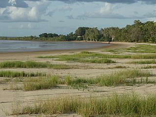
Nanum is a coastal residential locality in Weipa Town, Far North Queensland, Australia. In the 2016 census Nanum had a population of 921 people.

Gununa, sometimes spelt Gunana, is a rural town on Mornington Island within the locality of Wellesley Islands in the Shire of Mornington, Queensland, Australia. In the 2016 census, Gununa had a population of 1,136 people.

<span class="mw-page-title-main">Willow Vale, Queensland</span> Suburb of Gold Coast City, Queensland, Australia

Willow Vale is a rural locality in the City of Gold Coast, Queensland, Australia. In the 2016 census, Willow Vale had a population of 2,096 people.

<span class="mw-page-title-main">Kingsholme, Queensland</span> Suburb of Gold Coast City, Queensland, Australia

Kingsholme is a rural locality in the City of Gold Coast, Queensland, Australia. In the 2021 census, Kingsholme had a population of 782 people.

<span class="mw-page-title-main">Clairview</span> Suburb of Isaac Region, Queensland, Australia

Clairview is a coastal town and locality in the Isaac Region, Queensland, Australia. In the 2016 census, the locality of Clairview had a population of 145 people.

<span class="mw-page-title-main">Weipa Town</span> Local government area in Queensland, Australia

Weipa Town is a local government area in Far North Queensland, Australia. It covers the town of Weipa on the western coast of the Cape York Peninsula, including the localities of Rocky Point, Trunding, Nanum, Evans Landing, and Weipa Airport. It is an unusual local government area as it is not governed and managed by a council elected by residents but rather by the company Rio Tinto Aluminium through a governing body called the Weipa Town Authority. In June 2018, Weipa Town had a population of 4,240.

<span class="mw-page-title-main">Mount Abundance, Queensland</span> Suburb of Maranoa Region, Queensland, Australia

Mount Abundance is a locality in the Maranoa Region, Queensland, Australia. In the 2021 census, Mount Abundance had a population of 178 people.

<span class="mw-page-title-main">Mount Debateable, Queensland</span> Suburb of North Burnett Region, Queensland, Australia

Mount Debateable is a rural locality in the North Burnett Region, Queensland, Australia. In the 2021 census, Mount Debateable had a population of 40 people.

Mount Gardiner is a rural locality in the Livingstone Shire, Queensland, Australia. In the 2016 census Mount Gardiner had a population of 34 people.

Mission River is a coastal rural locality split between the Shire of Cook and the Aboriginal Shire of Napranum in Queensland, Australia. In the 2016 census, Mission River had a population of 987 people.

Rocky Point is a residential locality in the Weipa Town, Queensland, Australia. In the 2016 census Rocky Point had a population of 1,957 people.

<span class="mw-page-title-main">Trunding</span> Suburb of Weipa Town, Queensland, Australia

Trunding is a coastal residential locality in the Weipa Town, Queensland, Australia. In the 2021 census, Trunding had a population of 929 people.

Wangan is a town and a locality in the Cassowary Coast Region, Queensland, Australia. In the 2021 census, the locality of Wangan had a population of 612 people.

<span class="mw-page-title-main">Yalangur, Queensland</span> Suburb of Toowoomba Region, Queensland, Australia

Yalangur is a rural locality in the Toowoomba Region, Queensland, Australia. In the 2021 census, Yalangur had a population of 55 people.

Humboldt is a rural locality in the Central Highlands Region, Queensland, Australia. In the 2021 census, Humboldt had a population of 49 people.

<span class="mw-page-title-main">Albatross Bay</span> Bay in Queensland, Australia

Albatross Bay is a bay on the eastern shores of the Gulf of Carpentaria, Queensland, Australia.

References

  1. 1 2 3 Australian Bureau of Statistics (28 June 2022). "Evans Landing (SAL)". 2021 Census QuickStats. Retrieved 28 February 2023. OOjs UI icon edit-ltr-progressive.svg
  2. 1 2 "Evans Landing – locality in Weipa Town (entry 12015)". Queensland Place Names. Queensland Government . Retrieved 29 December 2020.
  3. "Bays - Queensland". Queensland Open Data. Queensland Government. 12 November 2020. Archived from the original on 25 November 2020. Retrieved 25 November 2020.
  4. "Queensland Globe". State of Queensland . Retrieved 5 February 2018.
  5. Australian Bureau of Statistics (27 June 2017). "Evans Landing (SSC)". 2016 Census QuickStats. Retrieved 20 October 2018. OOjs UI icon edit-ltr-progressive.svg
  6. "Emergency services facilities - Queensland". Queensland Open Data. Queensland Government. 18 November 2020. Archived from the original on 24 November 2020. Retrieved 24 November 2020.
  7. "Recreational Boating Facilities Queensland". Queensland Open Data. Queensland Government. 12 November 2020. Archived from the original on 22 November 2020. Retrieved 22 November 2020.
  8. "Land for public recreation - Queensland". Queensland Open Data. Queensland Government. 20 November 2020. Archived from the original on 22 November 2020. Retrieved 22 November 2020.