
The Glenelg tram line is a tram/light rail line in Adelaide. Apart from a short street-running section in Glenelg, the line has its own reservation, with minimal interference from road traffic.

Morphettville Racecourse is the main horse racing course for the Australian state of South Australia, incorporating two separate tracks. It is situated in the Adelaide suburb of Morphettville, and is about 10 km from the Adelaide city centre, and is home to the South Australian Jockey Club.

Glandore is a suburb of Adelaide, South Australia, partly in the City of Marion and partly in the City of West Torrens. The name is believed to come from Glandore in County Cork, Ireland, whence the family of John O'Dea, one of the original property owners of the area, came.

Wayville is an inner-southern suburb of Adelaide in the City of Unley. It is most notable for hosting of the Royal Adelaide Show at the Adelaide Showgrounds.

Black Forest is an inner southern suburb of Adelaide, South Australia. It is located in the City of Unley, bounded by the Glenelg tram line (north-west), the Seaford railway line (south-east), South Road (west) and East Avenue (east).
South Road and its southern section as Main South Road outside of Adelaide is a major north–south conduit connecting Adelaide and the Fleurieu Peninsula, in South Australia. It is one of Adelaide's most important arterial and bypass roads. As South Road, it is designated part of route A2 within suburban Adelaide. As Main South Road, it is designated part of routes A13 and B23.
Plympton is an inner south-western suburb of Adelaide, South Australia. The name is believed to have been given by Henry Mooringe Boswarva to a private subdivision in the area, naming after his home town in Devon, England. It was accepted as an official name for the suburb in 1944.

Plympton Park is an inner south-western suburb of Adelaide 8 km from the CBD, in the state of South Australia and falls under the City of Marion. The post code for Plympton Park is 5038. It is adjacent to Park Holme, Plympton, South Plympton, and Morphettville. It is bordered to the east by Marion Road, to the west by Park Terrace, to the south by Taranna Avenue and to the north by the Glenelg tram line.

Goodwood Road is a major north–south arterial road, approximately 10 kilometres long, in Adelaide, South Australia. It runs between the Adelaide city centre and Adelaide's southern suburbs of Pasadena and Panorama.

The Metropolitan Adelaide Transport Study, or "MATS Plan" as it became known, was a comprehensive transport plan released in 1968 proposing a number of road and rail transport projects for the metropolitan area of Adelaide, South Australia.

Cross Road is a major arterial road that travels east–west through the inner southern suburbs of the Australian city of Adelaide. It is designated route A3.

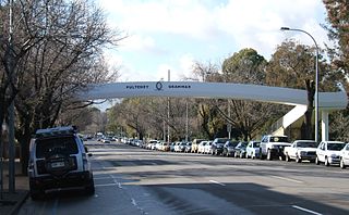
Anzac Highway is an 8.7-kilometre-long (5.4 mi) main arterial road heading southwest from the city of Adelaide, the capital of South Australia, to the beachside suburb of Glenelg.

Ashford is an inner southwestern suburb of Adelaide, in the City of West Torrens. It is triangular in shape and bordered by South Road (west), Anzac Highway (southeast) and Everard Avenue (north). Two of the main features of the suburb are Ashford Hospital and Ashford Special School.

Bowden is an inner northern suburb of Adelaide, South Australia. It is located in the City of Charles Sturt.

Glenelg North is a seaside suburb of Adelaide, South Australia. It is located in both the City of Holdfast Bay and the City of West Torrens.

Glenelg East is a residential suburb 9 kilometres (5.6 mi) south-west of the centre of Adelaide, South Australia. It is characterised by quarter-acre blocks with heritage homes and parks intermingled with contemporary modern homes and low-rise multi-dwelling units.
The Holdfast Bay railway line was a railway in western Adelaide. The line started in the city from the Adelaide railway station, and then headed west. From approximately where Henley Beach Road currently is, the railway then followed an almost direct route to the seaside suburb of Glenelg.
South Terrace is one of the four terraces which bound the city centre of Adelaide, the capital of South Australia.
Marion Road is a north–south arterial road through the western suburbs of Adelaide, South Australia, named after its traversal through the suburb of Marion and the local government area of City of Marion. It is designated part of route A14.


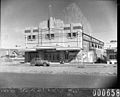 The Roxy in 1939
 The Roxy in 2008
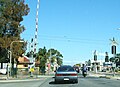 South Road at the former Everard Park tram crossing before construction of a tram overpass
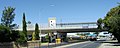 South Road Tram Overpass and tram stop 6

