
The Kenilworth Avenue Historic District is a historic district in the northwestern portion of Dayton, Ohio, United States. Composed largely of houses constructed after the Great Flood of 1913, the district features examples of several prominent architectural styles, and it has received both local and federal recognition.

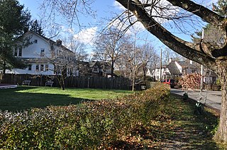
The Firth–Glengarry Historic District encompasses a residential area of Winchester, Massachusetts consisting of well-preserved high quality houses built mainly between 1880 and 1900. The district lies between Wildwood Street and Wedge Pond, and includes properties on Pine Street, Glengarry Road, Grassmere Avenue, Dix Street, and Wildwood Street; houses on Curtis Street and Curtis Circle, are excluded from the district. Much of the area was laid out by developer William Firth, and many of its houses were designed by Boston architect Robert Coit. The 13.44-acre (5.44 ha) district was listed on the National Register of Historic Places in 1989.

The Robert Bacon House is a historic house at 6 Mystic Valley Parkway in Winchester, Massachusetts. Built about 1830, it is one of the town's only surviving examples of high-style transitional Federal/Greek Revival styling. It was built for a local businessman whose nearby mills were major employers of the period. The house was listed on the National Register of Historic Places in 1989.

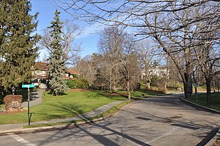
The Wedgemere Historic District encompasses the largest single 19th-century residential development of Winchester, Massachusetts. It is one of the town's largest surviving 19th-century residential subdivisions, with a concentration of high-quality residences built between about 1890 and 1920. The district was listed on the National Register of Historic Places in 1989.

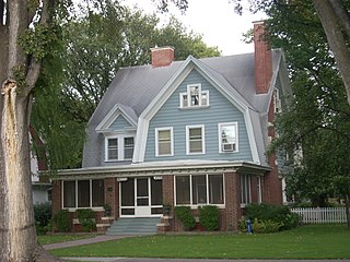
The John H. McGill House is a historic house at 56 Vernon Street in Medford, Massachusetts. Built in 1902 to a design by local architect Robert Coit, it is one of the city's finest examples of Colonial Revival architecture. It was listed on the National Register of Historic Places in 1980.

The Metropolitan District Commission Pumping House is a historic water pumping station, adjacent to Spot Pond in the Middlesex Fells Reservation, on Woodland Road in Stoneham, Massachusetts. Built in 1901 by the Metropolitan District Commission (MDC), it is one of Stoneham's finest examples of Renaissance Revival architecture. The building was listed on the National Register of Historic Places in 1984, and included in the Middlesex Fells Reservoirs Historic District in 1990.

The Nobility Hill Historic District is a residential historic district roughly bounded by Chestnut and Maple Streets and Cedar Avenue in Stoneham, Massachusetts. The district includes a number of high quality houses representing a cross section of fashionable housing built between 1860 and 1920. It was added to the National Register of Historic Places in 1990.

Hammond Heights is an historic neighborhood subdivision on the west side of Worcester, Massachusetts. It includes properties along Germain, Haviland, Highland, and Westland Streets and Institute Road, most of which were built between 1890 and 1918, and is a good example of a turn-of-the-century residential subdivision, with a diversity of period architectural styles. The district was listed on the National Register of Historic Places in 1980.

The House at 13 Sheffield Road in Wakefield, Massachusetts is a well-preserved Craftman/Bungalow style house. The 1 1⁄2-story house was built c. 1918 out of fieldstone with a stucco exterior. The roof has extended eaves with exposed purlins, and a large cross-gable section on the right side. Strapwork on the walls give the house a Tudor Revival appearance. The subdivision in which it was built was laid out in 1916 in an area known as Cowdrey's Hill, after an early settler.

The Day Estate Historic District encompasses part of a subdivided estate at the corner of Commonwealth Avenue and Dartmouth Street in Newton, Massachusetts, United States. The district is bounded by Commonwealth, Dartmouth, Chestnut, and Prince Streets, and includes six houses located on Commonwealth and Dartmouth. It was originally owned by Henry Day, a banker, who in 1896 built the house at 321 Chestnut Street. The block was subdivided during a building boom in the 1920s, and the new houses were built between 1928 and 1930. All six houses are high quality Tudor Revival structures, five of them designed by William J. Freethey. Day's estate house is now home to the All Newton Music School, and the rest of the northeastern portion of the estate has more modern construction. The district was listed on the National Register of Historic Places in 1990.
The Farlow Hill Historic District is a residential historic district in the Newton Corner area of Newton, Massachusetts. It includes houses on Shornecliffe Road, Beechcroft Road, Farlow Road, Huntington Road, and a few properties on immediately adjacent streets. Most of the houses in the district were built between 1899 and the late 1920s and are either Craftsman or Colonial Revival in their style. The area was created by the subdivision of the estate of John Farlow, and includes 37 large and well-appointed houses, generally architect-designed, on ample lots. The district was listed on the National Register of Historic Places in 1990.

The Gray Cliff Historic District is a residential historic district encompassing a cluster of exceptionally high quality houses built in Newton, Massachusetts, between about 1890 and 1940. When first listed on the National Register of Historic Places in 1986, it included only the eight houses at 35, 39, 43, 53, 54, 64, 65, and 70 Gray Cliff Road, which were predominantly Shingle style house built before the turn of the 20th century. The district was expanded in 1990 to include an adjacent area known as The Ledges, where the houses were built between 1900 and 1940, and are mainly Colonial Revival and Tudor Revival in their styling.

The Monadnock Road Historic District is a residential historic district encompassing a cohesive subdivision of a former estate in the 1920s in the Chestnut Hill section of Newton, Massachusetts. The development was typical of Newton's explosive residential growth at that time, and includes primarily Tudor Revival houses. The district was listed on the National Register of Historic Places in 1990.
The Morton Road Historic District encompasses an example of a small residential subdivision in Newton, Massachusetts that was attractively designed in 1915. The architect-designed subdivision filled in an area otherwise surrounded by roads that had been developed earlier, and was built out between 1915 and 1928, with a fairly uniform use of Craftsman and Tudor Revival styling. The district was listed on the National Register of Historic Places in 1990.

The Pine Ridge Road–Plainfield Street Historic District encompasses a residential subdivision in the Waban section of Newton, Massachusetts. It includes 44 properties on Pine Ridge Road and Plainfield Street between Chestnut Street and Upland Road, and includes a few properties on the latter two streets. The area was laid out for development in the 1880s after the arrival of suburban rail service, and was built out by the 1930s. The district was listed on the National Register of Historic Places in 1990.

The Windsor Road Historic District is a residential historic district just north of the village of Waban in Newton, Massachusetts. It includes 48 houses on Windsor, Kent and Hereford Roads, a cul-de-sac subdivision adjacent to the village center and the Brae Burn Country Club, which was mostly developed between 1888 and 1920. It was added to the National Register of Historic Places in 1990.
The Joseph Bell DeRemer House is a Dutch Colonial Revival style house located on Belmont Road in the Near Southside Historic District of Grand Forks, North Dakota, United States. The house was built in 1906 for the architect Joseph Bell DeRemer, who designed the home himself. As an example of a middle-class house the structure is remarkable for details and quality associated with the public and commercial buildings designed by the DeRemer firm.

Forest Park is a Victorian garden district located in Springfield, Massachusetts, developed between 1880 and 1920. It is the city's most populous neighborhood, and surrounds the 735-acre Frederick Law Olmsted-designed Forest Park, for which the neighborhood is named. The Forest Park neighborhood has nature and recreation within walking distance. To the west, I-91 separates Forest Park from the Connecticut River. A 195-acre section of the neighborhood was listed on the National Register of Historic Places in 1982 as the Forest Park Heights Historic District.

The University Neighborhood Historic District comprises the residential area south of the University of Wyoming in Laramie, Wyoming. The 24-block historic district is bounded on the north by University Avenue, the east by 15th Street, the south by Custer Street, and the west by 6th Street. The neighborhood's period of significance is from 1872 to 1958, a time when the area around the university was developed. Architectural styles in the district are diverse and the neighborhood is almost entirely composed of single-family residences.

Newport Village Historic District is a neighborhood in Boardman, Ohio. The neighborhood is bordered by the City of Youngstown, Ohio to the north and east, Glenwood Avenue to the west, and Forest Glen Estates Historic District to the south. Newport Village is known for its quaint tree-lined residential streets and early twentieth century Tudor revival and colonial revival architecture.


