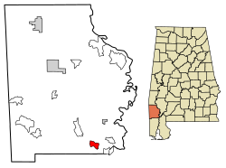
Fairford, Alabama | |
---|---|
Coordinates: 31°10′06″N88°03′51″W / 31.16833°N 88.06417°W | |
Country | United States |
State | Alabama |
County | Washington |
Area | |
• Total | 3.07 sq mi (7.95 km2) |
• Land | 3.07 sq mi (7.95 km2) |
• Water | 0.00 sq mi (0.00 km2) |
Elevation | 75 ft (23 m) |
Population (2020) | |
• Total | 161 |
• Density | 52.43/sq mi (20.24/km2) |
Time zone | UTC-6 (Central (CST)) |
• Summer (DST) | UTC-5 (CDT) |
Area code | 251 |
GNIS feature ID | 118118 [2] |
Fairford is a census-designated place and unincorporated community in Washington County, Alabama, United States. Its population was 186 as of the 2010 census. [3]
Census | Pop. | Note | %± |
---|---|---|---|
2020 | 161 | — | |
U.S. Decennial Census [4] |
The United States Census Bureau (USCB), officially the Bureau of the Census, is a principal agency of the U.S. Federal Statistical System, responsible for producing data about the American people and economy. The Census Bureau is part of the U.S. Department of Commerce and its director is appointed by the President of the United States.
The United States had an official estimated resident population of 334,914,895 on July 1, 2023, according to the U.S. Census Bureau. This figure includes the 50 states and the District of Columbia but excludes the population of five unincorporated U.S. territories as well as several minor island possessions. The United States is the third most populous country in the world. The Census Bureau showed a population increase of 0.4% for the twelve-month period ending in July 2022, below the world average annual rate of 0.9%. The total fertility rate in the United States estimated for 2022 is 1.665 children per woman, which is below the replacement fertility rate of approximately 2.1.
In the United States, a metropolitan statistical area (MSA) is a geographical region with a relatively high population density at its core and close economic ties throughout the region. Such regions are not legally incorporated as a city or town would be and are not legal administrative divisions like counties or separate entities such as states. As a result, sometimes the precise definition of a given metropolitan area will vary between sources. The statistical criteria for a standard metropolitan area were defined in 1949 and redefined as a metropolitan statistical area in 1983.
Washington County is a county located in the southwestern part of the U.S. state of Alabama. As of the 2020 census, the population was 15,388. The county seat is Chatom. The county was named in honor of George Washington, the first President of the United States. In September 2018 The United States Office of Management and Budget (OMB) added Washington County to the Mobile, Alabama Metropolitan Statistical Area. It is also part of the larger Mobile-Daphne-Fairhope, AL Combined Statistical Area.
In the United States, a county or county equivalent is an administrative or political subdivision of a U.S. state or other territories of the United States which consists of a geographic area with specific boundaries and usually some level of governmental authority. The term "county" is used in 48 states, while Louisiana and Alaska have functionally equivalent subdivisions called parishes and boroughs, respectively. The specific governmental powers of counties vary widely between the states, with many providing some level of services to civil townships, municipalities, and unincorporated areas. Certain municipalities are in multiple counties; New York City is uniquely partitioned into five counties, referred to at the city government level as boroughs. Some municipalities have been consolidated with their county government to form consolidated city-counties, or have been legally separated from counties altogether to form independent cities. Conversely, those counties in Connecticut, Rhode Island, eight of Massachusetts's 14 counties, and Alaska's Unorganized Borough have no government power, existing only as geographic distinctions.
Morgan County is a county located in the north central Piedmont region and the lake country region of the U.S. state of Georgia. As of the 2020 census, the population was 20,097. The county seat is Madison.
A census-designated place (CDP) is a concentration of population defined by the United States Census Bureau for statistical purposes only.
White Americans are Americans who identify as white people. This group constitutes the majority of the people in the United States. According to the 2020 census, 71%, or 235,411,507 people, were White alone or in combination, and 61.6%, or 204,277,273 people, were White alone. This represented a national white demographic decline from a 72.4% white alone share of the U.S. population in 2010.
The United States has a racially and ethnically diverse population. At the federal level, race and ethnicity have been categorized separately. The most recent United States census recognized five racial categories, as well as people who belong to two or more of the racial categories. The United States also recognizes the broader notion of ethnicity. The 2000 census and 2010 American Community Survey inquired about the "ancestry" of residents, while the 2020 census allowed people to enter their "origins". The Census Bureau also classified respondents as either Hispanic or Latino, identifying as an ethnicity, which comprises the minority group in the nation.
The 1990 United States census, conducted by the Census Bureau, determined the resident population of the United States to be 248,709,873, an increase of 9.8 percent over the 226,545,805 persons enumerated during the 1980 census.
The 1890 United States census was taken beginning June 2, 1890. The census determined the resident population of the United States to be 62,979,766, an increase of 25.5 percent over the 50,189,209 persons enumerated during the 1880 census. The data reported that the distribution of the population had resulted in the disappearance of the American frontier.
The 1980 United States census, conducted by the Census Bureau, determined the resident population of the United States to be 226,545,805, an increase of 11.4% over the 203,184,772 persons enumerated during the 1970 census. It was the first census in which a state—California—recorded a population of 20 million people, as well as the first in which all states recorded populations of over 400,000.
The 1790 United States census was the first United States census. It recorded the population of the whole United States as of Census Day, August 2, 1790, as mandated by Article 1, Section 2, of the Constitution and applicable laws. In the first census, the population of the United States was enumerated to be 3,929,214 inhabitants.
The 1860 United States census was the eighth census conducted in the United States starting June 1, 1860, and lasting five months. It determined the population of the United States to be 31,443,322 in 33 states and 10 organized territories. This was an increase of 35.4 percent over the 23,069,876 persons enumerated during the 1850 census. The total population included 3,953,762 slaves.
The 1920 United States census, conducted by the Census Bureau during one month from January 5, 1920, determined the resident population of the United States to be 106,021,537, an increase of 15.0 percent over the 92,228,496 persons enumerated during the 1910 census.