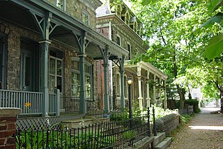
Chestnut Hill is a neighborhood in the Northwest Philadelphia section of Philadelphia, Pennsylvania, United States. It is known for the high incomes of its residents and high real estate values, as well as its private schools.

Powelton Village is a neighborhood of mostly Victorian, mostly twin homes in the West Philadelphia section of Philadelphia, Pennsylvania. It is a national historic district that is part of University City. Powelton Village extends north from Market Street to Spring Garden Street, east to 32nd Street, west to 40th and Spring Garden Streets, and to 44th and Market Streets.

The Automobile Alley neighborhood and Automobile Alley Historic District in Oklahoma City is an upscale Urban area, located roughly along North Broadway Avenue in Downtown Oklahoma City. The district contains numerous low and mid-rise heritage buildings once home to the city's automobile dealerships, that today hosts many of the city's top bars and restaurants, retail shops, and urban residences alongside modern construction consisting mostly of residential housing and hotels. Automobile Alley is listed in the National Historic Register of neighborhoods.

East Falls is a neighborhood in Lower Northwest, Philadelphia, Pennsylvania, United States. It lies on the east bank of the "Falls of the Schuylkill," cataracts submerged in 1822 by the Schuylkill Canal and Fairmount Water Works projects. East Falls sits next to the Germantown, Roxborough, Allegheny West, and the Nicetown-Tioga neighborhoods. Wissahickon Valley Park separates it from Manayunk, Philadelphia.

Broad Street is a major arterial street in Philadelphia, Pennsylvania. The street runs for approximately 13 miles (21 km), beginning at the intersection of Cheltenham Avenue on the border of Cheltenham Township and the West/East Oak Lane neighborhoods of North Philadelphia to the Philadelphia Navy Yard in South Philadelphia. It is Pennsylvania Route 611 along its entire length with the exception of its northernmost part between Old York Road and Pennsylvania Route 309 and the southernmost part south of Interstate 95.

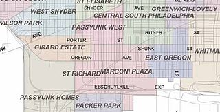
Marconi Plaza is an urban park square located in South Philadelphia, Philadelphia, Pennsylvania, United States. The plaza was named to recognize the 20th-century cultural identity in Philadelphia of the surrounding Italian American enclave neighborhood and became the designation location of the annual Columbus Day Parade.

The Cliffs is a historic country house located near 33rd and Oxford Streets in East Fairmount Park, Philadelphia. It is a Registered Historic Place.

Spring Garden is a neighborhood in central Philadelphia, Pennsylvania, bordering Center City on the north. Spring Garden is a neighborhood that combines diverse residential neighborhoods and significant cultural attractions.

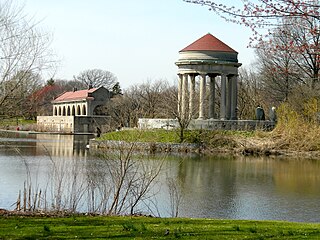
Franklin Delano Roosevelt (FDR) Park is a park located along the Delaware River in the southernmost point of South Philadelphia, Pennsylvania, comprising some 348 acres (1.41 km2) which includes a 146-acre (0.59 km2) golf course, about 125 acres (0.51 km2) of buildings, roadways, pathways for walking, landscaped architecture, and a variety of picnic and recreation areas placed within about 77 acres (310,000 m2) of natural lands including ponds and lagoons.

Memorial Hall is a Beaux-Arts style building which is located in the Centennial District of West Fairmount Park, Philadelphia, Pennsylvania. Built as the art gallery for the 1876 Centennial Exposition, it is the only major structure from that exhibition to survive. It subsequently housed the Pennsylvania Museum of Industrial Art.

Historic RittenhouseTown, sometimes referred to as Rittenhouse Historic District, encompasses the remains of an early industrial community which was the site of the first paper mill in British North America. The mill was built in 1690 by William Rittenhouse and his son Nicholas on the north bank of Paper Mill Run near Philadelphia, Pennsylvania. The district, off Lincoln Drive near Wissahickon Avenue in Fairmount Park, includes six of up to forty-five original buildings. RittenhouseTown was listed on the National Register of Historic Places and was designated a National Historic Landmark District on April 27, 1992.

Poplar is a neighborhood in Lower North Philadelphia, Pennsylvania, United States. It is located north of Callowhill, between Spring Garden/Fairmount and Northern Liberties, bounded roughly by Girard Avenue to the north, North Broad Street to the west, Spring Garden Street to the south, and 5th Street to the east. The neighborhood is predominantly residential, with commercial frontage on Broad Street and Girard Avenue and some industrial facilities to the west of the railroad tracks along Percy St. and 9th St.

The Lower Woodward Avenue Historic District, also known as Merchant's Row, is a mixed-use retail, commercial, and residential district in downtown Detroit, Michigan, located between Campus Martius Park and Grand Circus Park Historic District at 1201 through 1449 Woodward Avenue and 1400 through 1456 Woodward Avenue. The district was listed on the National Register of Historic Places in 1999.

Entranceways at Main Street at Lamarck Drive and Smallwood Drive are a set of complementary residential subdivision stone entranceways built in 1926. They are located on Main Street in the hamlet of Snyder, New York within the town of Amherst, which is located in Erie County. These entranceways are markers representing the American suburbanization of rural areas through land development associated with transportation on the edges of urban developments. The Smallwood entranceway is a pair of symmetric groupings of stone gatehouses and posts flanking the two sides of the drive at Main Street. The Lamarck entranceway is a pair of Y-shaped and U-shaped stone half-walls flanking the two sides of the drive at Main Street. The entranceways were added to the National Register of Historic Places on December 7, 2005.

The Wissahickon Memorial Bridge, originally called and still also known as the Henry Avenue Bridge, is a stone and concrete bridge that carries Henry Avenue over Wissahickon Creek and Lincoln Drive in Fairmount Park in Philadelphia, Pennsylvania.

The Four Corners Historic District is the intersection of Broad and Market Streets in Newark, New Jersey. It is the site of the city's earliest settlement and the heart of Downtown Newark that at one time was considered the busiest intersection in the United States. The area that radiates twenty-two square blocks from the crossroads is a state and federal historic district.

Edmund Beaman Gilchrist was an American architect, best remembered for his English-Cotswold and French-Norman suburban houses.

The Ford Motor Company - Columbus Assembly Plant is a historic building in Downtown Columbus, Ohio. The Ford plant was constructed in 1914, to designs by John Graham. The plant operated until 1939. In later years, it became the Kroger Co. Columbus Bakery, operating until 2019. The building was sold in 2020, and is planned to be redeveloped into a large residential complex, announced in 2021. The building was added to the National Register of Historic Places and Columbus Register of Historic Properties in 2021.

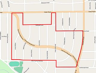
The Euclid Golf Allotment, also known as the Euclid Golf Historic District, is a historic district located in Cleveland Heights, Ohio, in the United States. Roughly bounded by Cedar Road, Coventry Road, West St. James Parkway, and Ardleigh Drive, the 142-acre (0.57 km2) site contains primarily residential homes built between 1913 and 1929. The historic district is built on land formerly owned by John D. Rockefeller and at one time leased to the Euclid Golf Club for its back nine holes, and it takes its name from this historic factoid. The Euclid Golf Allotment is a largely undisturbed example of an early 20th century planned community containing American Craftsman, Colonial Revival, French Renaissance Revival, Italian Renaissance Revival, Prairie School, Shingle Style, and Tudor Revival architecture.

Girard Avenue is a major commercial and residential street in Philadelphia. For most of its length it runs east–west, but at Frankford Avenue it makes a 135-degree turn north. Parts of the road are signed as U.S. Route 13 and U.S. Route 30.


