
Cibecue is a census-designated place (CDP) in Navajo County, Arizona, United States, on the Fort Apache Indian Reservation. The population was 1,713 in the 2010 United States Census.

Landmark is a census-designated place (CDP) in Pulaski County, Arkansas, United States. Per the 2020 census, the population was 3,585. It is part of the Little Rock–North Little Rock–Conway Metropolitan Statistical Area.

Discovery Bay is a census-designated place (CDP) in eastern Contra Costa County, California in the United States, about 60 miles (97 km) from San Francisco. It is located in the San Francisco Bay Area. As of 2020, its population was 15,358, a 15% percent gain from 13,352 at the 2010 census.

Orangevale is a census-designated place (CDP) in Sacramento County, California, United States. It is part of the Sacramento–Arden-Arcade–Roseville Metropolitan Statistical Area. The population was 33,960 at the 2010 census, up from 26,705 at the 2000 census. It is located approximately 25 miles (40 km) northeast of Sacramento. The community is known for its rolling hills that offer the best views of the Sierra Nevada mountain range, its foothills, and a rural environment in the middle of a growing metropolitan area. Some residential properties in the area are zoned to accommodate horses and orchards. It has a ZIP Code of 95662.
Alum Rock is a district of San Jose, California, located in East San Jose. Formerly an independent town, it has been a neighborhood of San Jose since the 1950s, though some portions are still unincorporated as a census-designated place. Alum Rock is one of San Jose's most notable and historic Chicano/Mexican-American districts. It is home to Alum Rock Park, the oldest municipal park in California and one of the largest in the country.

Inverness Highlands North is an unincorporated area and census-designated place (CDP) in Citrus County, Florida, United States. The population was 2,707 at the 2020 census, up from 2,401 at the 2010 census. It is part of the Homosassa Springs, Florida Metropolitan Statistical Area.

Waimalu is a census-designated place (CDP) in Honolulu County, Hawaiʻi, United States. The population was 13,817 at the 2020 census.

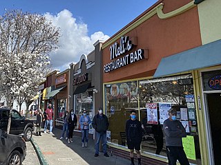
Brentwood is a town in Prince George's County, Maryland, United States. Per the 2020 census, the population was 3,828. Brentwood is located within 1-mile (1.6 km) of Washington, D.C. The municipality of Brentwood is located just outside the northeast boundary of the District of Columbia and surrounded by the communities of Mount Rainier, Cottage City, North Brentwood, and the nearby Hyattsville. Along the Route 1 Corridor, Brentwood is part of the Gateway Arts District.
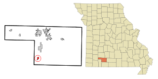
Spokane is a census-designated place in Christian County, Missouri, United States. The population was 177 at the 2010 census. It is part of the Springfield, Missouri, Metropolitan Statistical Area.

Brentwood is an inner-ring suburb of St. Louis, located in St. Louis County, Missouri, United States. The population was 8,233 at the 2020 census.

Helena Valley Northwest is a census-designated place (CDP) in Lewis and Clark County, Montana, United States. The population was 3,482 at the 2010 census. It is part of the Helena Micropolitan Statistical Area.
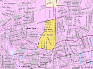
Baywood is a hamlet and census-designated place (CDP) in the Town of Islip in Suffolk County, on Long Island, in New York, United States. The population was 7,350 at the 2010 census.

Blue Point is a hamlet and census-designated place in Suffolk County on Long Island, New York, United States. The population was 5,156 at the 2020 census. Blue Point is in the Town of Brookhaven.
Central Islip is a hamlet and census-designated place (CDP) within the Town of Islip in Suffolk County, New York, United States. The population was 34,450 at the 2010 census.

Holbrook is a hamlet and census-designated place (CDP) in Suffolk County, New York, United States. The population was 27,195 at the 2010 census. The community borders the eastern side of Long Island MacArthur Airport.

Jennings Lodge is a census-designated place and unincorporated community in Clackamas County, Oregon, United States. Located between Milwaukie and Gladstone. As of the 2020 census, it had a total population of 7,503.

Fairwood is an unincorporated community and census-designated place (CDP) in King County, Washington, United States. As of the 2010 census the population was 19,396.

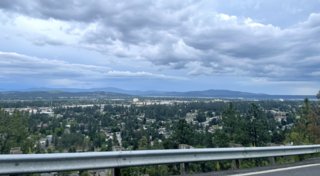
Country Homes is a census-designated place (CDP) in Spokane County, Washington, United States. The population was 6,251 at the 2020 census. The campus of Whitworth University is located in Country Homes. It is a largely suburban area that blends into the north side of the city of Spokane and the neighboring CDPs of Town and Country and Fairwood.

Greenacres is a locale and former census-designated place (CDP) in Spokane County, Washington, United States. The locale is almost entirely split between the city of Spokane Valley and unincorporated Spokane County, with a small portion being located within the city of Liberty Lake. Greenacres retains its own post office.
Town and Country is a census-designated place (CDP) in Spokane County, Washington, United States. The population was 5,068 at the 2020 census.


