
The Lackawanna River is a 42-mile-long (68 km) tributary of the Susquehanna River in Northeastern Pennsylvania. It flows through a region of the northern Pocono Mountains that was once a center of anthracite coal mining in the United States. It starts in north Wayne County, Pennsylvania and ends in east Luzerne County, Pennsylvania in Duryea, Pennsylvania. The lower reaches of the river flow through the urban areas of Scranton, which grew around its banks in the 19th century as an industrial center. Its name comes from a Lenape word meaning "stream that forks".

Hunlock Creek is a tributary of the Susquehanna River in Luzerne County, Pennsylvania, in the United States. It is approximately 7.8 miles (12.6 km) long and flows through Lehman Township and Hunlock Township. The watershed of the creek has an area of 32.5 square miles (84 km2) and is situated in northwestern Luzerne County. It has one named tributary, which is known as Roaring Brook, and a number of unnamed and unofficially named tributaries, such as "West Branch Hunlock Creek".

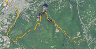
Spring Brook is a tributary of the Lackawanna River in Lackawanna County and Luzerne County, in Pennsylvania, in the United States. It is approximately 17 miles (27 km) long and flows through Covington Township, Spring Brook Township, and Moosic in Lackawanna County and Pittston Township in Luzerne County. The watershed of the stream has an area of 57.2 square miles (148 km2). It is designated as a High-Quality Coldwater Fishery and a Migratory Fishery above Interstate 476 and as a Coldwater Fishery and a Migratory Fishery below it. A section is also designated as Class A Wild Trout Waters. The stream's tributaries include Panther Creek, Plank Bridge Creek, Rattlesnake Creek, Green Run, Monument Creek, and Covey Swamp Creek. It has a relatively high level of water quality and is very slightly acidic, with a pH of 6.4 to 6.9.
Stafford Meadow Brook is a tributary of the Lackawanna River in Lackawanna County, Pennsylvania, in the United States. It is approximately 11.2 miles (18.0 km) long and flows through Roaring Brook Township, Scranton, and Moosic. The watershed of the stream has an area of 14.1 square miles (37 km2). Part of it is designated as a High-Quality Coldwater Fishery and a Migratory Fishery. The other part is a Warmwater Fishery and a Migratory Fishery. The stream has one named tributary, which is known as Mountain Lake Run. Stafford Meadow Brook has a very high level of water quality for much of its length and part of it meets the criteria for an Exceptional Value designation. The stream begins on the Pocono Plateau and flows through the Moosic Mountains in a mountainous watershed. Its channel has been substantially altered in its lower reaches.

Roaring Brook is a tributary of the Lackawanna River in Lackawanna County, Pennsylvania, in the United States. It is approximately 21 miles (34 km) long and flows through Covington Township, Madison Township, Moscow, Roaring Brook Township, Elmhurst Township, Dunmore, and Scranton. The watershed of the stream has an area of 56.3 square miles (146 km2). Its named tributaries include Little Roaring Brook, Rock Bottom Creek, White Oak Run, Van Brunt Creek, Bear Brook, and East Branch Roaring Brook. It has a high level of water quality for much of its length. However, it is affected by abandoned mining land, stormwater, and other impacts in its lower reaches. Reservoirs in the watershed include the Hollister Reservoir, the Elmhurst Reservoir, and others. The stream also flows through the Nay Aug Gorge and passes over the Nay Aug Falls, which are on the National Register of Geologic Landmarks. It flows through a concrete channel in its lower reaches. The topography of the watershed contains rolling hills in its upper reaches and the mountainous land of the Moosic Mountains in its lower reaches.
Aylesworth Creek is a tributary of the Lackawanna River in Lackawanna County, Pennsylvania, in the United States. It is approximately 4.9 miles (7.9 km) long and flows through Carbondale Township and the boroughs of Mayfield and Archbald. The watershed of the creek has an area of 6.73 square miles (17.4 km2). Part of the creek is impaired by abandoned mine drainage and/or resource extraction. The creek tends to be slightly acidic, but its iron, manganese, and aluminum concentrations do not need reduction to meet its total maximum daily load requirements. Its watershed is in the Appalachian Mountain section of the ridge and valley physiographic province. The headwaters of the creek are in the Moosic Mountains. The rock formations in the watershed mainly consist of interbedded sedimentary rock and sandstone.
Rush Brook is a tributary of the Lackawanna River in Lackawanna County, Pennsylvania, in the United States. It is approximately 5.1 miles (8.2 km) long and flows through Greenfield Township, Scott Township, Carbondale Township, Mayfield, and Jermyn. The watershed of the stream has an area of 6.01 square miles (15.6 km2). The stream is not considered to be impaired and all but its lower reaches are mostly undisturbed. However, Pennsylvania Route 107 is in its vicinity. The stream begins on the Allegheny Plateau and flows through a water gap. It is a perennial stream.
Racket Brook is a tributary of the Lackawanna River in Wayne County and Lackawanna County, in Pennsylvania, in the United States. It is approximately 3.6 miles (5.8 km) long and flows through Canaan Township in Wayne County and Carbondale Township and Carbondale in Lackawanna County. The watershed of the stream has an area of 5.29 square miles (13.7 km2). The stream has no named tributaries, but has two unnamed tributaries. It is not designated as impaired, but it does experience minor flow loss. It drains part of the Moosic Mountains and also flows through a ravine known as the Brownell Ravine.
Coal Brook is a tributary of the Lackawanna River in Lackawanna County, Pennsylvania, in the United States. It is approximately 2.2 miles (3.5 km) long and flows through Fell Township and Carbondale. The watershed of the stream has an area of 1.93 square miles (5.0 km2). The stream experiences flow loss and is impaired by flow alterations and metals. Most of its length is heavily impacted by past mining and the lower reaches are in an underground culvert. The Coal Brook Colliery was historically in the stream's watershed. Coal Brook is a first-order stream and is designated as a Coldwater Fishery and a Migratory Fishery.
Wilson Creek is a tributary of the Lackawanna River in Lackawanna County, Pennsylvania, in the United States. It is approximately 3.7 miles (6.0 km) long and flows through Fell Township. The watershed of the creek has an area of 3.82 square miles (9.9 km2). The creek is impaired by metals and pH from abandoned mine drainage. Some reaches of it also experience total flow loss. There are three discharges of acid mine drainage entering the creek: the Upper Wilson Outfall, the Lower Wilson Outfall, and the Molensky Slope Outfall. The watershed of the creek is in the Appalachian Mountain section of the Ridge and Valley physiographic province. The main rock types in the watershed are interbedded sedimentary rock and sandstone. The creek flows past areas of disturbed mining land.
Meredith Brook is a tributary of the Lackawanna River in Susquehanna County, Lackawanna County, and Wayne County, in Pennsylvania, in the United States. It is approximately 2.1 miles (3.4 km) long and flows through Forest City and Clifford Township in Susquehanna County, Vandling in Lackawanna County, and Clinton Township in Wayne County. In the early 1900s, the stream was clear in its lower reaches despite receiving water from a borehole and culm banks. There are two shallow lakes in the watershed: Lake Erie and Kennedy Pond. Various fish inhabit the lakes.
Brace Brook is a tributary of the Lackawanna River in Wayne County and Susquehanna County, in Pennsylvania, in the United States. It is approximately 2.9 miles (4.7 km) long and flows through Mount Pleasant Township and Clinton Township in Wayne County and Forest City in Susquehanna County. The watershed of the stream has an area of 2.99 square miles (7.7 km2). The stream is not designated as impaired. It drains a portion of the Moosic Mountains. The surficial geology in its vicinity consists of alluvium, surface mining land, coal dumps, fill, Wisconsinan Till, and bedrock containing sandstone and shale. A reservoir known as the Brace Brook Reservoir is in the watershed. The stream's drainage basin is designated as a Coldwater Fishery and a Migratory Fishery.
The East Branch Lackawanna River is a tributary of the Lackawanna River in Wayne County and Susquehanna County, in Pennsylvania, in the United States. It is approximately 12.7 miles (20.4 km) long and flows through Preston Township in Wayne County and Ararat Township, Herrick Township, Union Dale, and Clifford Township. The watershed of the river has an area of 19.0 square miles (49 km2). The river is not designated as impaired and has a relatively high level of water quality. A portion of the Moosic Mountains are in its vicinity. Source ponds in the river's watershed include Bone Pond, Dunns Pond, Independent Lake, Lake Lorain, Mud Pond, and Orson Pond. There are a number of wetlands and swamps in the watershed, but agricultural and forested land is present as well.
The West Branch Lackawanna River is a tributary of the Lackawanna River in Susquehanna County, Pennsylvania, in the United States. It is approximately 9.5 miles (15.3 km) long and flows through Ararat Township, Herrick Township, and Union Dale. The watershed of the river has an area of 16.8 square miles (44 km2). The river is not designated as an impaired stream and it has a high level of water quality. Lakes and wetlands in the river's watershed include Ball Lake, Fiddle Lake, Hathaway Lake, Lake Romobe, Lewis Lake, Lowe Lake, and Sink Hole Swamp. The river is also dammed by at least two dams: the Romobe Lake Dam and the Hathaway Pond Dam.
Gardner Creek is a tributary of the Susquehanna River in Lackawanna County, Pennsylvania, in the United States. It is approximately 9.1 miles (14.6 km) long and flows through Newton Township and Ransom Township. The watershed of the creek has an area of 18.1 square miles (47 km2). The creek is not designated as an impaired waterbody. The surficial geology in its vicinity mainly consists of alluvial terrace, alluvium, Wisconsinan Till, and bedrock. However, Wisconsinan Ice-Contact Stratified Drift, fill, alluvial fan, peat, and wetlands also occur. The creek is the main source of flooding in Ransom Township.
Trout Brook is a tributary of South Branch Tunkhannock Creek in Lackawanna County and Wyoming County, in Pennsylvania, in the United States. It is approximately 5.0 miles (8.0 km) long and flows through West Abington Township in Lackawanna County and Clinton Township in Wyoming County. The stream has no named tributaries, but it does have ten unnamed tributaries. There are also a number of wetlands in the watershed of the stream. The stream is classified as a Coldwater Fishery. Its watershed occupies portions of three municipalities in Wyoming County and five in Lackawanna County.
East Branch Tunkhannock Creek is a tributary of Tunkhannock Creek in Susquehanna County, Pennsylvania, in the United States. It is approximately 19 miles (31 km) long and flows through Gibson Township, Herrick Township, Clifford Township, and Lenox Township, Susquehanna County, Pennsylvania. The watershed of the creek has an area of 68.3 square miles (177 km2). The creek has four named tributaries: Little Creek, Tinker Creek, Dundaff Creek, and Idlewild Creek. It is not designated as an impaired waterbody and is a freestone stream in its upper reaches. The topography of the watershed has been described as "rough and hilly".
Little Creek is a tributary of East Branch Tunkhannock Creek in Susquehanna County, Pennsylvania, in the United States. It is approximately 3.0 miles (4.8 km) long and flows through Herrick Township and Clifford Township. The watershed of the creek has an area of 4.56 square miles (11.8 km2). The creek has one unofficially named tributary, which is known as Tinker Hollow. Little Creek is designated as Class A Wild Trout Waters. The surficial geology in its vicinity mainly consists of Wisconsinan Till and alluvium.
Tinker Creek is a tributary of East Branch Tunkhannock Creek in Susquehanna County, Pennsylvania, in the United States. It is approximately 4.3 miles (6.9 km) long and flows through Clifford Township. The watershed of the creek has an area of 5.02 square miles (13.0 km2). The creek is not designated as an impaired waterbody and has no named tributaries. It is classified as Class A Wild Trout Waters.
Dundaff Creek is a tributary of East Branch Tunkhannock Creek in Susquehanna County and Lackawanna County, in Pennsylvania, in the United States. It is approximately 6.7 miles (10.8 km) long and flows through Clifford Township in Susquehanna County and Greenfield Township in Lackawanna County. The watershed of the creek has an area of 10.3 square miles (27 km2). The creek has no named tributaries and is not designated as an impaired waterbody.
