Falmouth, Virginia

Last updated

Falmouth, Virginia
2016-09-12 09 37 05 View northwest across central Falmouth, Stafford County, Virginia from U.S. Route 1 and U.S. Route 17 Business (Cambridge Street).jpg
Central Falmouth, as seen from US 1 and US 17 Bus
Stafford County Virginia incorporated and unincorporated areas Falmouth highlighted.svg
Location in Stafford County and the state of Virginia.
Coordinates: 38°19′54″N77°27′41″W / 38.33167°N 77.46139°W / 38.33167; -77.46139
CountryUnited States
State Virginia
County Stafford
Area
  Total3.2 sq mi (8.4 km2)
  Land3.1 sq mi (8.1 km2)
  Water0.1 sq mi (0.3 km2)
Elevation
56 ft (17 m)
Population
 (2020) [1]
  Total4,956
  Density1,500/sq mi (590/km2)
Time zone UTC−5 (Eastern (EST))
  Summer (DST) UTC−4 (EDT)
Area code 540
FIPS code 51-27264 [2]
GNIS feature ID1494919 [3]

Falmouth is a census-designated place (CDP) in Stafford County, Virginia, United States. Situated on the north bank of the Rappahannock River at the falls, the community is north of and opposite the city of Fredericksburg. Recognized by the U.S. Census Bureau as a census-designated place (CDP), Falmouth's population was 4,956 as of the 2020 census.

Contents

History

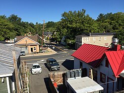
Founded in 1728 by the same act of the Virginia General Assembly that established neighboring Fredericksburg, Falmouth was created as a port town on the Rappahannock to serve inhabitants living north of the river within the vast Northern Neck holdings of Lord Fairfax. His agent, Robert "King" Carter, promoted the establishment of the town, and the Carter family played a dominant role in the town's development throughout much of the colonial period.

Hunter's Ironworks, also known as Rappahannock Forge, was an iron furnace located near Falmouth. Thomas Jefferson made special provision to protect the ironworks during the American Revolution.

The Falmouth Road was a colonial road that served as the main route connecting Winchester in the Shenandoah Valley to the port of Falmouth. This road follows a northwesterly route that was originally called the Shenandoah Hunting Path and crossed through the Piedmont counties of Stafford and Fauquier before passing over the Blue Ridge Mountains at Ashby's Gap. Modern day US Highway 17 follows much of this route. Originally located within King George County, Falmouth became part of Stafford when county lines were redrawn in 1776.

It was a stop on the Richmond, Fredericksburg and Potomac Railroad in the 19th century which was replaced by CSXT today. During the American Civil War, Falmouth was occupied by Union forces in 1862 and 1863, and Northern commanders located their headquarters southeast of the town during the Fredericksburg and Chancellorsville campaigns. In May 1864, Union wounded and Confederate prisoners from the Battles of the Wilderness and Spotsylvania Court House were transported through the area to the wharves at Belle Plain on Potomac Creek, a tributary of the Potomac River, located east of Falmouth.

Today Falmouth is a residential community and a suburb of Fredericksburg. Among the community's significant historic structures is Belmont, the home of American artist Gari Melchers, now a historic house museum administered by University of Mary Washington. Chatham Manor, the 1771 home of William Fitzhugh and a Union headquarters during the Civil War, is located downstream from Falmouth, opposite the historic district of Fredericksburg. It is administered by the National Park Service as part of Fredericksburg and Spotsylvania County Battlefields Memorial National Military Park and now serves as park headquarters.

In addition to Belmont, Carlton, Clearview, Conway House, Falmouth Historic District, Hunter's Ironworks, Union Church and Cemetery, and White Oak Church are listed on the National Register of Historic Places. [4]

Geography

Falmouth is located at 38°19′54″N77°27′41″W / 38.33167°N 77.46139°W / 38.33167; -77.46139 (38.331790, 77.461361). [5]

According to the United States Census Bureau, Falmouth has a total area of 3.2 square miles (8.4 km2), of which, 3.1 square miles (8.1 km2) of it is land and 0.1 square miles (0.3 km2) of it (3.09%) is water.

Demographics

As of the census [2] of 2000, there were 3,624 people, 1,323 households, and 997 families residing in the CDP. The population density was 1,155.6 people per square mile (445.6/km2). There were 1,412 housing units at an average density of 450.3/sq mi (173.6/km2). The racial makeup of the CDP was 89.29% White, 6.46% Black or African American, 0.22% Native American, 1.08% Asian, 0.61% from other races, and 2.35% from two or more races. Hispanic or Latino of any race were 2.15% of the population.

There were 1,323 households, out of which 35.1% had children under the age of 18 living with them, 58.5% were married couples living together, 11.9% had a female householder with no husband present, and 24.6% were non-families. 18.9% of all households were made up of individuals, and 6.7% had someone living alone who was 65 years of age or older. The average household size was 2.68 and the average family size was 3.03.

In the CDP, the population was spread out, with 26.2% under the age of 18, 7.3% from 18 to 24, 27.6% from 25 to 44, 25.6% from 45 to 64, and 13.3% who were 65 years of age or older. The median age was 38 years. For every 100 females, there were 92.3 males. For every 100 females age 18 and over, there were 89.3 males.

The median income for a household in the CDP was $57,697, and the median income for a family was $66,989. Males had a median income of $39,280 versus $31,202 for females. The per capita income for the CDP was $25,544. About 5.9% of families and 7.3% of the population were below the poverty line, including 12.6% of those under age 18 and none of those age 65 or over.

Recreation

Lake Mooney is a 520-acre reservoir in Falmouth, Virginia. [6] Mooney is the newest lake in Virginia. [7] The lake was named for Jason Mooney who was a Stafford sheriff's deputy who died in the line of work in 2007. The lake is primarily used for recreation. [7] The lake is stocked with game fish and officially opened for sport fishing in July 2017. [8] [9]

Notable residents and natives

Climate

The climate in this area is characterized by hot, humid summers and generally mild to cool winters. According to the Köppen Climate Classification system, Falmouth has a humid subtropical climate, abbreviated "Cfa" on climate maps. [10]

Related Research Articles

<span class="mw-page-title-main">Stafford County, Virginia</span> County in Virginia, United States

Stafford County is located in the Commonwealth of Virginia. It is a suburb outside of Washington D.C. It is approximately 40 miles (64 km) south of D.C. It is part of the Northern Virginia region, and the D.C. area. It is one of the fastest growing, and highest-income counties in America. As of the 2020 census, the population sits at 156,927. Its county seat is Stafford.

<span class="mw-page-title-main">Spotsylvania County, Virginia</span> County in Virginia, United States

Spotsylvania County is a county in the U.S. state of Virginia. As of the July 2021 estimate, the population was 145,300. Its county seat is Spotsylvania Courthouse.

<span class="mw-page-title-main">Fredericksburg, Virginia</span> Independent city in Virginia, United States

Fredericksburg is an independent city in Virginia, United States. As of the 2020 census, the population was 27,982. It is 48 miles (77 km) south of Washington, D.C., and 53 miles (85 km) north of Richmond. The Bureau of Economic Analysis of the United States Department of Commerce combines the city of Fredericksburg with neighboring Spotsylvania County for statistical purposes.

<span class="mw-page-title-main">Potomac, Maryland</span> Census-designated place in Maryland, United States

Potomac is an unincorporated community and census-designated place in Montgomery County, Maryland, United States. As of the 2020 census, it had a population of 47,018. It is named after the nearby Potomac River. A part of the Washington metropolitan area, many Potomac residents work in nearby Washington, D.C., and Northern Virginia.

<span class="mw-page-title-main">West Falmouth, Massachusetts</span> Census-designated place in Massachusetts, United States

West Falmouth is a census-designated place (CDP) in the town of Falmouth in Barnstable County, Massachusetts, United States. The population was 1,738 at the 2010 census.

<span class="mw-page-title-main">Jolivue, Virginia</span> Census-designated place in Virginia, United States

Jolivue is a census-designated place (CDP) in Augusta County, Virginia, United States. The population was 1,129 at the 2010 census. It is part of the Staunton–Waynesboro Micropolitan Statistical Area.

<span class="mw-page-title-main">Port Royal, Virginia</span> Town in Virginia, United States

Port Royal is an incorporated town in Caroline County, Virginia, United States. The population was 126 at the 2010 census.

<span class="mw-page-title-main">Tappahannock, Virginia</span> Town in Virginia, United States

Tappahannock is the oldest town in Essex County, Virginia, United States. The population was 2,375 at the 2010 census, up from 2,068 at the 2000 census. Located on the Rappahannock River, Tappahannock is the county seat of Essex County. Its name comes from an Algonquian language word lappihanne, meaning "Town on the rise and fall of water" or "where the tide ebbs and flows." The Rappahannock is a tidal estuary from above this point and downriver to its mouth on Chesapeake Bay.

<span class="mw-page-title-main">Fort Hunt, Virginia</span> Census-designated place in Virginia, United States

Fort Hunt is a census-designated place (CDP) in Fairfax County, Virginia, United States. The area is named after Fort Hunt, which was built on the bank of the Potomac River in 1897 to defend Washington, D.C. from naval attack and is now a public park. The area is also notable for its high population of senior citizens and for being one of the first suburbs in wealthy Fairfax County. The population was 17,231 at the 2020 census.

<span class="mw-page-title-main">Great Falls, Virginia</span> Census-designated place in Virginia, United States

Great Falls is a census-designated place in Fairfax County, Virginia, United States. The population at the 2020 census was 15,953.

<span class="mw-page-title-main">Lorton, Virginia</span> Census-designated place in Virginia, United States

Lorton is a census-designated place (CDP) in Fairfax County, Virginia, United States. The population was 20,072 as of the 2020 census.

<span class="mw-page-title-main">Newington, Virginia</span> Census-designated place in Virginia, United States

Newington is a census-designated place (CDP) in Fairfax County, Virginia, United States. As of the 2020 census, the population was 13,223. The population was 12,943 at the 2010 census. The 2010 census showed a significant decrease after half the population was split off to the newly created Newington Forest CDP.

<span class="mw-page-title-main">Laurel, Virginia</span> Census-designated place in Virginia, United States

Laurel is a census-designated place (CDP) in western Henrico County, Virginia, United States. The population was 17,769 at the 2020 United States Census. It is the county seat of Henrico County.

<span class="mw-page-title-main">Woodbridge, Virginia</span> Census-designated place in Virginia, United States

Woodbridge is a census-designated place (CDP) in Prince William County, Virginia, United States, located 20 miles (32 km) south of Washington, D.C. Bounded by the Occoquan and Potomac rivers, Woodbridge had 44,668 residents at the 2020 census.

<span class="mw-page-title-main">Spotsylvania Courthouse, Virginia</span> Unincorporated census-designated place in Virginia, United States

Spotsylvania Courthouse is a census-designated place (CDP) and the county seat of Spotsylvania County, Virginia, United States, located 10 miles (16 km) southwest of Fredericksburg. Recognized by the U.S. Census Bureau as a census designated place (CDP), the population was 5,610 at the 2020 census.

<span class="mw-page-title-main">Aquia Harbour, Virginia</span> CDP in Virginia, United States

Aquia Harbour is a census-designated place (CDP) in Stafford County, Virginia, United States, 13 miles (21 km) north of Fredericksburg. The population was 6,727 at the 2010 census. Aquia Church, erected in 1757 and now a National Historic Landmark, is located west of the community.

<span class="mw-page-title-main">Lake Morton-Berrydale, Washington</span> Census-designated place in Washington, United States

Lake Morton-Berrydale is a census-designated place (CDP) in King County, Washington, United States. The population was 10,474 at the 2020 census.

<span class="mw-page-title-main">Marine Corps Base Quantico</span> American military installation

Marine Corps Base Quantico is a United States Marine Corps installation located near Triangle, Virginia, covering nearly 55,148 acres of southern Prince William County, Virginia, northern Stafford County, and southeastern Fauquier County. Used primarily for training purposes, MCB Quantico is known as the "Crossroads of the Marine Corps".

<span class="mw-page-title-main">Fairfax Station, Virginia</span> Census-designated place in Virginia, United States

Fairfax Station is a census-designated place (CDP) in Fairfax County, Virginia, United States. The population was 12,420 at the 2020 census. Located in Northern Virginia, its center is located 22 miles (35 km) southwest of Washington, D.C.

<span class="mw-page-title-main">Cherry Hill, Prince William County, Virginia</span> Census-designated place in Virginia, United States

Cherry Hill is a census-designated place (CDP) in Prince William County, Virginia, United States. The population was 16,000 according to the 2010 Census. As of the 2020 census, it was estimated to be 23,683. The CDP is made up of the Cherry Hill peninsula, to the northeast of the town of Dumfries.

References

  1. "Profile of General Population and Housing Characteristics: 2020 Demographic Profile Data (DP-1): Falmouth CDP, Virginia". United States Census Bureau . Retrieved March 20, 2024.
  2. 1 2 "U.S. Census website". United States Census Bureau . Retrieved January 31, 2008.
  3. "US Board on Geographic Names". United States Geological Survey. October 25, 2007. Retrieved January 31, 2008.
  4. "National Register Information System". National Register of Historic Places . National Park Service. July 9, 2010.
  5. "US Gazetteer files: 2010, 2000, and 1990". United States Census Bureau. February 12, 2011. Retrieved April 23, 2011.
  6. "Lake Mooney". dgif.virginia.gov. Virginia Department of Game and Inland Fisheries. Retrieved January 10, 2020.
  7. 1 2 "Lake Mooney Reservoir". staffordcountyva.gov. Stafford Virginia. Retrieved January 10, 2020.
  8. "Stafford's 5.5 billion gallon reservoir turns five". Fredericksburg Today. December 30, 2019. Retrieved January 10, 2020.
  9. "Lake Mooney will be open for fishing on Saturday, July 1". Potomac Local. June 26, 2017. Retrieved January 10, 2020.
  10. Climate Summary for Falmouth, Virginia