
Baffin Island, in the Canadian territory of Nunavut, is the largest island in Canada and the fifth-largest island in the world. Its area is 507,451 km2 (195,928 sq mi) with a population density of 0.03/km²; the population was 13,039 according to the 2021 Canadian census; and it is located at 68°N70°W. It also contains the city of Iqaluit, which is the capital of Nunavut.

Baffin Bay, located between Baffin Island and the west coast of Greenland, is defined by the International Hydrographic Organization as a marginal sea of the Arctic Ocean. It is sometimes considered a sea of the North Atlantic Ocean. It is connected to the Atlantic via Davis Strait and the Labrador Sea. The narrower Nares Strait connects Baffin Bay with the Arctic Ocean. The bay is not navigable most of the year because of the ice cover and high density of floating ice and icebergs in the open areas. However, a polynya of about 80,000 km2 (31,000 sq mi), known as the North Water, opens in summer on the north near Smith Sound. Most of the aquatic life of the bay is concentrated near that region.
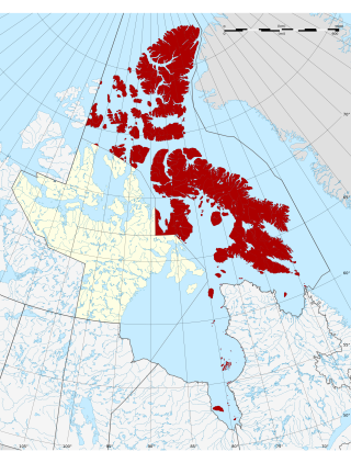
The Qikiqtaaluk Region, Qikiqtani Region or the Baffin Region is the easternmost, northernmost, and southernmost administrative region of Nunavut, Canada. Qikiqtaaluk is the traditional Inuktitut name for Baffin Island. Although the Qikiqtaaluk Region is the most commonly used name in official contexts, several notable public organizations, including Statistics Canada prior to the 2021 Canadian census, use the older term Baffin Region.

Mansel Island, a member of the Arctic Archipelago, is an uninhabited island in Qikiqtaaluk Region, Nunavut. It is located in Hudson Bay off of Quebec's Ungava Peninsula. At 3,180 km2 (1,230 sq mi) in size, it is the 159th largest island in the world, and Canada's 28th largest island. Its topography features a gently undulating limestone lowland with elevations not exceeding 100 m.

Devon Island is an island in Canada and the largest uninhabited island in the world. It is located in Baffin Bay, Qikiqtaaluk Region, Nunavut, Canada. It is one of the largest members of the Arctic Archipelago, the second-largest of the Queen Elizabeth Islands, Canada's sixth-largest island, and the 27th-largest island in the world. It has an area of 55,247 km2 (21,331 sq mi). The bedrock is Precambrian gneiss and Paleozoic siltstones and shales. The highest point is the Devon Ice Cap at 1,920 m (6,300 ft) which is part of the Arctic Cordillera. Devon Island contains several small mountain ranges, such as the Treuter Mountains, Haddington Range and the Cunningham Mountains. The notable similarity of its surface to that of Mars has attracted interest from scientists.

Bylot Island lies off the northern end of Baffin Island in Nunavut Territory, Canada. Eclipse Sound to the southeast and Navy Board Inlet to the southwest separate it from Baffin Island. Parry Channel lies to its northwest. At 11,067 km2 (4,273 sq mi) it is ranked 71st largest island in the world and Canada's 17th largest island. The island measures 180 km (110 mi) east to west and 110 km (68 mi) north to south and is one of the largest uninhabited islands in the world. While there are no permanent settlements on this Canadian Arctic island, Inuit from Pond Inlet and elsewhere regularly travel to Bylot Island. An Inuit seasonal hunting camp is located southwest of Cape Graham Moore.

Festuca (fescue) is a genus of flowering plants belonging to the grass family Poaceae. They are evergreen or herbaceous perennial tufted grasses with a height range of 10–200 cm (4–79 in) and a cosmopolitan distribution, occurring on every continent except Antarctica. The genus is closely related to ryegrass (Lolium), and recent evidence from phylogenetic studies using DNA sequencing of plant mitochondrial DNA shows that the genus lacks monophyly. As a result, plant taxonomists have moved several species, including the forage grasses tall fescue and meadow fescue, from the genus Festuca into the genus Lolium, or alternatively into the segregate genus Schedonorus.

Auyuittuq National Park is a national park located on Baffin Island's Cumberland Peninsula, in the Qikiqtaaluk Region of Nunavut, the largest political subdivision of Canada. The park was initially known as Baffin Island National Park when it was established in 1972, but the name was changed in 1976 to its current name to better reflect the region and its history. It features many terrains of Arctic wilderness, such as fjords, glaciers, and ice fields. Although Auyuittuq was established in 1972 as a national park reserve, it was upgraded to a full national park in 2000.
There are over 190 vascular plant species on the Norwegian Arctic archipelago of Svalbard. This figure does not include algae, mosses, and lichens, which are non-vascular plants. For an island so far north, this number of species constitutes an astonishing variety of plant life. Because of the harsh climate and the short growing season, all the plants are slow growing. They seldom grow higher than 10 cm (4 in)

Sirmilik National Park is a national park located in Qikiqtaaluk, Nunavut, Canada, established in 1999. Situated within the Arctic Cordillera, the park is composed of three areas: most of Bylot Island with the exception for a few areas that are Inuit-owned lands, Oliver Sound, and Baffin Island's Borden Peninsula. Much of the park is bordered by water.
The Cumberland Sound belugas are a distinct population of belugas residing in the Cumberland Sound region of the Labrador Sea off the coast of Nunavut, Canada Individuals of this population reside in the sound year-round, congregating in its extreme north exclusively at Clearwater Fjord during the summer for calving. The Cumberland Sound beluga population is considered fairly isolated and genetically distinct from other beluga populations, with a notable number of haplotypes and microsatellite loci not found elsewhere.

Nettilling Lake is a cold freshwater lake located toward the south end of Baffin Island in the Qikiqtaaluk Region, Nunavut, Canada. It is the 30th largest lake in the world by area, and the world's largest lake on an island, with an area of 5,542 km2 (2,140 sq mi) and a maximum length of 123 km (76 mi). The lake is in the Great Plain of the Koukdjuak about 280 km (170 mi) northwest of Iqaluit. The Arctic Circle crosses the lake. The lake's name is of Inuktitut origin, coming from the word for the adult ringed seal (netsilak). Franz Boas explored its southern shore in 1884.

Festuca altaica, also known as the altai fescue, or the northern rough fescue, is a perennial bunchgrass with a wide native distribution in the Arctic, from central Asia to eastern North America. It was first described in 1829 by Carl Bernhard von Trinius. It is under the synonym F. scabrella, the rough fescue.
Qikiqtaaluk, Unorganized in Nunavut, Canada, is part of a larger census division known as the Qikiqtaaluk Region. This area covers the whole Qikiqtaaluk Region outside the 13 communities such as Iqaluit, Resolute or Grise Fiord. Baffin has a rocky mountainous landscape. Prior to the 2021 Canadian census it was known as Baffin.

Coburg Island is an uninhabited island in Qikiqtaaluk, Nunavut, Canada. It is one of the members of Queen Elizabeth Islands located in Baffin Bay's Lady Ann Strait. It is separated from Ellesmere Island by Glacier Strait; Devon Island is to the south.

The Baffin Mountains are a mountain range running along the northeastern coast of Baffin Island and Bylot Island, Nunavut, Canada. The ice-capped mountains are part of the Arctic Cordillera and have some of the highest peaks of eastern North America, reaching a height of 1,525–2,146 metres (5,003–7,041 ft) above sea level. While they are separated by bodies of water to make Baffin Island, they are closely related to the other mountain ranges that make the much larger Arctic Cordillera mountain range.

Mount Odin is a mountain in Qikiqtaaluk, Nunavut, Canada. It is located in Auyuittuq National Park along the Akshayuk Pass, 46 km (29 mi) north of Pangnirtung and south of Mount Asgard. Mount Odin is the highest mountain on Baffin Island.

Tasiujarjuaq formerly Soper Lake is a large, irregularly shaped lake in the Qikiqtaaluk Region, Nunavut, Canada. It is located on Baffin Island's Meta Incognita Peninsula. The Inuit name references the lake's meromictic attribute, a mixture of fresh and salt water caused by a set of reversing falls and 9–10 m (30–33 ft) tides in Pleasant Inlet. The fresh water of Soper River drains into the lake which then drains into the salt water of Pleasant Inlet before reaching the Arctic Ocean.

Kangiqtugaapik formerly Clyde Inlet is a body of water in eastern Baffin Island, Qikiqtaaluk Region, Nunavut. Its mouth opens into the Davis Strait from the west.
Hantzsch Island is an uninhabited island in the Qikiqtaaluk Region of Nunavut, Canada. It is located in Frobisher Bay off the southern tip of Baffin Island's Meta Incognita Peninsula and the northeastern tip of Edgell Island. The closest community is the Inuit hamlet of Sanikiluaq, 800 km (500 mi) to the west on Flaherty Island.