Fishpond, Alabama | |
|---|---|
 Fishpond, Alabama  Fishpond, Alabama | |
| Coordinates: 32°52′04″N86°01′24″W / 32.86778°N 86.02333°W | |
| Country | United States |
| State | Alabama |
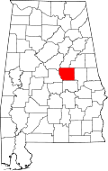
| County | Coosa |
| Elevation | 748 ft (228 m) |
| Time zone | UTC-6 (Central (CST)) |
| • Summer (DST) | UTC-5 (CDT) |
| Area codes | 256 & 938, 334 |
| GNIS feature ID | 156349 [1] |
Fishpond is an unincorporated community in Coosa County, Alabama, United States.