Kellyton, Alabama | |
|---|---|
Town | |
 Kellyton, Alabama in 2011 | |
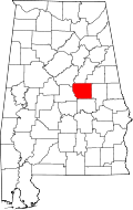
 Location of Kellyton in Coosa County, Alabama. | |
| Coordinates: 32°58′45″N86°02′09″W / 32.97917°N 86.03583°W [1] | |
| Country | United States |
| State | Alabama |
| County | Coosa |
| Area | |
• Total | 0.97 sq mi (2.51 km2) |
| • Land | 0.97 sq mi (2.50 km2) |
| • Water | 0 sq mi (0.00 km2) |
| Elevation | 748 ft (228 m) |
| Population (2020) | |
• Total | 129 |
| • Density | 133.4/sq mi (51.52/km2) |
| Time zone | UTC-6 (Central (CST)) |
| • Summer (DST) | UTC-5 (CDT) |
| Postal code | 35089 |
| Area codes | 256 & 938 |
| FIPS code | 01-39472 |
| GNIS feature ID | 2405933 [1] |
Kellyton is an incorporated town [3] in Coosa County, Alabama, United States. It had a population of 217 as of the 2010 census. [4]
Contents
The town is part of the Talladega-Sylacauga Micropolitan Statistical Area.