Flooding of the Pearl River

Last updated
Pearl River
Zhujiang
Humen Bridge-1.jpg
Pearl River in Humen near Humen Town
Zhujiangrivermap.png
The course of the Pearl River system through China and Vietnam
Location
Country China, Vietnam
Provinces Guangdong, Guangxi, Guizhou, Yunnan, Hunan, Jiangxi, Fujian
Physical characteristics
Length2,400 km (1,500 mi)
Basin size453,700 km2 (175,200 sq mi)
Discharge 
  average9,500 m3/s (340,000 cu ft/s)

The Pearl River (or Zhujiang) Basin is one of China's largest river basins, located in South China within total area approximately 453,700 square kilometers in Guangdong, Guangxi, Guizhou, Yunnan, Hunan, Jiangxi and Fujian provinces, and part of Northeastern Vietnam. [1]

Contents

The Pearl River basin consists of three main tributaries: the Xi River, Bei River, and Dong River, and many small rivers within the Pearl River Delta. The Xi River is the largest tributary within total length of 2,214 kilometers, and the average slope of the river is 0.58%. [2] The Bei River with a total length of 468 kilometers has the average slope of the river is 0.26%. The Dong water system has the main stream 520 kilometers long with the average slope of the river is 0.388%. Total annual water volume of the whole basin is 345.8 billion cubic meters, which is the second only to the Yangtze River in China. [2]

The floods in the Pearl River are mainly caused by heavy rains. Since the area of the river basin is wide and the intensity of heavy rain is high, the floods in the alpine hilly areas of the upper and middle reaches are fast, and there are no lakes in the middle reaches. [3] Therefore, in the case of continuous heavy rain, the floods are often formed with high peaks and large quantities in long duration, endangering the middle and lower reaches in the cities and towns with low land and large population, and vast farmland along the river, which restricts economic development and affects social stability. [4]

Flood characteristics

The Pearl River belongs to the rain-fall river and the flood comes from heavy rain. The causes of heavy rain are: [5]

Atmospheric circulation

Since the heavy rain is affected by the subtropical monsoon, and the cold and warm groups are in harmony. Also, it is affected by the topography, resulted in frontal type of heavy rain, which usually occurs in April to July, named the first flood season. [5]

Typhoons

The heavy rain is also affected by the typhoon, which usually occurs in August to September, called the later flood season. Rainfall in flood season accounts for about 80% of the whole year. Its characteristics are: a large amount of rainfall, a large intensity and a long duration. The regular pattern rule: Bei River first, then Dong River and Xi River. The rainstorm center: Bei River is in the area from Yingde to Qingyuan, Dong River is in the area of Jiulian Mountain, Xunwu and Shangping, while Xi River is in the Miao Mountain in the upper reaches of the Gui River, the Xingren in Laowang Mountain and Duan in Daming Mountain. The torrential rainstorms at the edge of the basin includes the city of Haifeng to Huidong in the east of Guangdong, Enping to Yangjiang in the west of Guangdong, and Qinzhou to Dongxing in southern Guangxi. [6]

The maximum average annual rainfall of 24h in the basin is 100-200mm, the coefficient of variation is 0.35~0.65, and the maximum annual rainfall of 24h is 848mm (Jinjiang Encheng Station). The annual variation of runoff in the basin corresponds to the rainfall, that the water volume in the flood season from April to September accounts for 70% to 80% of the total annual water. Since the large amount of rainfall and high intensity during the flood season, many tributaries are fan-shaped, and floods are easy to collect into the main stream at the same time. [7] There are many hills in the upper and middle reaches, and the flood convergence speed is relatively fast. There is no lake storage in the middle reaches, which it is easy to form floods with high peaks and large quantities. The biggest flood peaks in Bei River and Dong River often appear from May to June, and a flood lasts about 7 to 15 days. [8] The largest flood peak in the Xi River often appears from June to August, while the largest floods mostly occur from June to July, lasting for 30 to 45 days. The Xi flood is the main source of floods in the Pearl River Delta. Sometimes the floods of Xi River and Bei River cause serious disasters in the Pearl River Delta. [4]

Every year the typhoon season is from May to October. Typhoon land from Shenzhen, Guangdong, to the Pearl River Estuary in Taishan. A typhoon with a wind level of 8 or above in the center occurs on an average of 2 to 3 times per year, and a strong typhoon of 10 to 11 levels every 2 to 3 years. The invasion of the typhoon, sometimes results in even higher storm surges. [4]

Flood Disasters

Floods in the Pearl River Basin are frequent, especially in the middle reaches, lower reaches and deltas. Historical literature had described many such floods. According to statistics, the floods occurred 125 times in the Ming dynasty in the Xi River Basin, 181 times in the Qing Dynasty, and 17 times in the Republic of China. There were 24 floods occurred in the Bei River Basin before 1949 and 14 major floods in the Dong River Basin from 1864 to 1985. In the lower reaches of the Pearl River and in the delta, more than 32,200 hectares of floods were affected or affected by arable land. There were 26 times in the 18th century and 36 times in the 19th century. From 1915 to 1949, there were 22 times of arable land flooding area exceeding 66,700 hectares. There have been 12 heavy floods since the 1949. After the 1990s, the "94.6", "96.7" and "98.6" floods occurred, which the damages were very serious. [9]

Typical Flood

In July 1949, the typical floods encountered in the Xi River Flood and the Bei River. The flood was a basin flood of the Xi River caused by heavy rain formed by the front shear weather system. The flood mainly comes from the Lancang River and the Liujiang River had the largest proportion. The flood peak flow of the Wuzhou station is 48,900 cubic meters per second, which was equivalent to a 50-year flood. It is a single-peak type with a flow rate of over 30,000 cubic meters per second. After 18 days, the 30-day flood was 88.4 billion cubic meters, which was the first in the series of the largest 30-day flood. [10]

In June 1959, Dong River basin flood caused by heavy rain formed by frontal shear weather system. The flood mainly comes from Boluo. The Boluo station has a measured peak flow of 12,800 cubic meters per second and a reduction value of 14,100 cubic meters per second, which is equivalent to a flood in 100 years. [10]

In June 1994, there were 13 consecutive rains in South China. The Xi River and the Bei River were concurrently in the 50th year. When the two rivers flooded, they entered the Pearl River Delta network. The water level in the delta rose sharply, and the high water level lasted for a long time. More than 10 days. The flood disaster affected 70 cities (counties) in Guangxi and 39 cities (counties) in Guangdong, resulting in nearly 1.25 million hm² of affected farmland in Guangdong and Guangxi. The affected population reached 21.48 million, with 446 deaths and direct economic losses of about 28.4 billion yuan. [11]

In July 1996, heavy rains occurred in the southeastern Yunnan and central Guangxi areas of the Pearl River Basin. The rainstorm centre was in the old area of Bei River. From July 12 to 19, the rainfall reached 1,692 mm, and the maximum rainfall of 779 mm in 24 hours was Guangxi. The highest record of the Zhuang Autonomous Region. At 20 o'clock on the 19th, Liuzhou Station showed a peak water level of 92.43m, exceeding the warning water level of 10.93m, and the flood peak flow rate was 33700m³/s. It was a flood in 130 years. The affected farmland was 480,000 hm², and the affected population reached 8.17 million, with 249 deaths. The largest in Guangxi. 90% of the streets in the industrial city of Liuzhou are flooded. [10]

From June 5 to 27, 1998, heavy rains occurred in the Pearl River basin. There was a catastrophic flood in the Xi River in the past 100 years. The flood peak level is 26.51m in the Zhangzhou Hydrological Station with the flood peak flow of 52,900m³/s, which was the second largest flood in the Zhangzhou station since the founding of the People's Republic of China. According to the statistics of Guangdong and Guangxi provinces (autonomous regions), there has been no breakage on either side of the river. The number of people affected by the storm and flood reached 14.98 million, the area affected by crops was 903,300 hm², 156 people died, and the direct economic loss was about 16.03 billion yuan. [12]

In the beginning of July, 2001, the coastal areas of Guangxi and the Xi River Basin were flooded with heavy rains caused by the typhoon No. 0103 and No. 0104,. The Yujiang River experienced the largest flood since the founding of the People's Republic of China. On July 8, Nanning Hydrological Station showed a peak water level of 77.18m and a maximum flow of 13400m³/s. The storm and flood caused 14.465 million people in Guangxi and Guizhou to be affected, 32 people died due to the disaster, and the direct economic loss was 15.174 billion yuan. [12]

The period from May to October is the typhoon season on the southeast coast of China. Under a strong typhoon, it sometimes leads to a violent tide, which causes the seawall in the coastal tidal zone of the Pearl River Delta to be destroyed. [13]

Precautions

There are 926,600 feet of the cultivated land threatened by floods in the Pearl River Basin, affecting 20 million population. The Pearl River floods are mainly concentrated in the confluence zones of the Pearl River Delta, the Lancang River, and the Liutun River. These areas are densely populated and economically developed. [11] Although most of these areas have the embankment protection, the flood control standards are not strictly. Except for the Bei embankment in Guangzhou, which has is defended against floods likely to occur during a 20 year period, most of them have only defense for an expected 10 years of flooding. According to the principle of “combination of embankment, venting and storage”, in the 1980s, three flood control projects combined with dikes were planned: [14]

Related Research Articles

<span class="mw-page-title-main">Yue Chinese</span> Primary branch of Chinese spoken in southern China

Yue is a branch of the Sinitic languages primarily spoken in Southern China, particularly in the provinces of Guangdong and Guangxi.

<span class="mw-page-title-main">Pearl River Delta</span> Megalopolis in South China

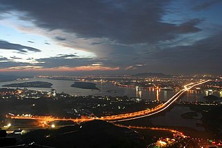
The Pearl River Delta Metropolitan Region is the low-lying area surrounding the Pearl River estuary, where the Pearl River flows into the South China Sea. Referred to as the Guangdong–Hong Kong–Macao Greater Bay Area in official documents, the region is one of the most densely populated and urbanized regions in the world, and is considered a megacity by numerous scholars. It is currently the wealthiest region in Southern China and one of the wealthiest regions in China along with the Yangtze River Delta in Eastern China and Jingjinji in Northern China. Most of the region is part of the Pearl River Delta Economic Zone, which is a special economic zone of China.

<span class="mw-page-title-main">Pearl River</span> Major river in southern China

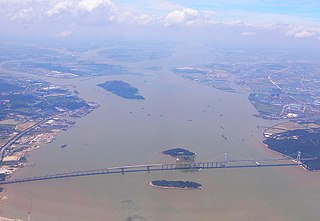
The Pearl River is an extensive river system in southern China. "Pearl River" is often also used as a catch-all for the watersheds of the Pearl tributaries within Guangdong, specifically the Xi ('west'), Bei ('north'), and Dong ('east'). These rivers all ultimately flow into the South China Sea through the Pearl River Delta. Measured from the farthest reaches of the Xi River, the 2,400-kilometer-long (1,500 mi) Pearl River system constitutes China's third-longest, after the Yangtze River and the Yellow River, and its second largest by volume, after the Yangtze. The 453,700 km2 (175,200 sq mi) Pearl River Basin drains the majority of Guangdong and Guangxi provinces, as well as parts of Yunnan, Guizhou, Hunan and Jiangxi; it also drains the northernmost parts of Vietnam's Northeast Cao Bằng and Lạng Sơn provinces. The Pearl River is famed as the river that flows through Guangzhou.

<span class="mw-page-title-main">Xi River</span> Western tributary of the Pearl River

The Xi River or Si-Kiang is the western tributary of the Pearl River in southern China. It is formed by the confluence of the Gui and Xun Rivers in Wuzhou, Guangxi. It originates from the eastern foot of the Maxiong Mountain in Qujing City, Yunnan Province. Then it flows east through Guangdong, and enters the Pearl River Delta just east of the Lingyang Gorge in Zhaoqing. The main branch of the Xi River flows southeast through the delta entering the South China Sea at Modao Men, just west of Macau. The major cities along the Xi include Wuzhou, Zhaoqing, and Jiangmen.

<span class="mw-page-title-main">Qingyuan</span> Prefecture-level city in Guangdong, Peoples Republic of China

Qingyuan, formerly romanized as Tsingyun, is a prefecture-level city in northern Guangdong province, China, on the banks of the Bei or North River. During the 2020 census, its total population was 3,969,473, out of whom 1,738,424 lived in the built-up area made of urbanized Qingcheng and Qingxin districts. The primary spoken language is Cantonese. Covering 19,015 km2 (7,342 sq mi), Qingyuan is Guangdong's largest prefecture-level division by land area, and it borders Guangzhou and Foshan to the south, Shaoguan to the east and northeast, Zhaoqing to the south and southwest, and Hunan province and Guangxi Zhuang Autonomous Region to the north. The urban core is surrounded by mountainous areas but is directly connected with Guangzhou and the Pearl River Delta by Highway 107.

<span class="mw-page-title-main">Typhoon Imbudo</span> Pacific typhoon in 2003

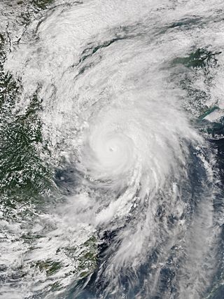
Typhoon Imbudo, known in the Philippines as Super Typhoon Harurot, was a powerful typhoon that struck the Philippines and southern China in July 2003. The seventh named storm and fourth typhoon of the season, Imbudo formed on July 15 to the east of the Philippines. The storm moved generally west-northward for much of its duration due to a ridge to the north. Favorable conditions allowed Imbudo to intensify, gradually at first before undergoing rapid deepening on July 19. After reaching typhoon status, Imbudo strengthened further to peak 10–minute sustained winds of 165 km/h (103 mph) on July 20. The typhoon made landfall on northern Luzon near peak intensity on July 22, but quickly weakened over land. Once in the South China Sea, Imbudo re-intensified slightly before making its final landfall in southern China near Yangjiang on July 24, dissipating the next day.

<span class="mw-page-title-main">Tropical Storm Kammuri (2002)</span> Pacific severe tropical storm in 2002

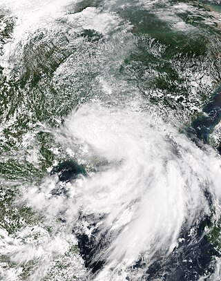
Severe Tropical Storm Kammuri, known in the Philippines as Tropical Storm Lagalag, killed hundreds of people in the wake of a deadly flood season in China. The system developed from a large monsoonal system that persisted toward the end of July 2002 near the Philippines. On August 2, a tropical depression formed off the northwest coast of Luzon and moved west-northwestward. Late on August 3, it intensified into Tropical Storm Kammuri off the coast of Hong Kong. A weakening ridge turned the storm northward toward the coast of China. The storm made landfall with late on August 4, after reaching peak winds of 100 km/h (65 mph). The system dissipated over the mountainous coastline of eastern China and merged with a cold front on August 7.

<span class="mw-page-title-main">Tropical Storm Bilis</span> Pacific severe tropical storm in 2006

Severe Tropical Storm Bilis, known in the Philippines as Tropical Storm Florita, was a weak tropical cyclone in July 2006 that caused catastrophic damage to areas of the Philippines, Taiwan, and southeastern China. The word Bilis, submitted by the Philippines, means 'speed' or 'swiftness' in Tagalog.

Zhujiang Brewery was established in 1985 and is a large state-owned enterprise which deals mainly in beer and related products such as labels, cartons, crates, etc. The brewery is one of the largest single site production facilities in the world, and produces Zhujiang Beer.

<span class="mw-page-title-main">2008 South China floods</span> 2008 natural disaster in southern China

The 2008 South China floods began on 26 May 2008. Four rounds of torrential rains with landslides and flooding lasted for 20 days and affected fifteen provinces in Eastern and Southern China.

<span class="mw-page-title-main">Zhujiang New Town</span> Area in Guangzhou, Guangdong, China

Zhujiang New Town or Zhujiang New City is a central business district in Tianhe District, Guangzhou city, Guangdong province, China. It is bounded by Huangpu Avenue on the north, the Pearl River on the south, Guangzhou Avenue on the west and the South China Expressway on the east.

The Eight Views of Ram City, also known as the Eight Sights of Guangzhou is the collective name for various collections of the eight most famous tourist attractions in Guangzhou, China, during different periods of its history. Collections of "Eight Views" is a common trope in Chinese travel literature.

<span class="mw-page-title-main">Tropical Storm Vongfong (2002)</span> Pacific tropical storm in 2002

Tropical Storm Vongfong affected China after a deadly flood season. The 14th named storm of the 2002 Pacific typhoon season, Vongfong developed as a tropical depression on August 10. Initially it was disorganized due to hostile conditions, and it failed to intensify significantly before crossing the Philippine island of Luzon. There, flooding forced 3,500 people to evacuate their homes. In the Philippines, the storm killed 35 people and caused $3.3 million in damage.

<span class="mw-page-title-main">2013 China–Russia floods</span>

During mid-August 2013 parts of eastern Russia and northeastern China were stricken by heavy flooding. At least 85 people died from the floods and more than 105 others were left missing as of August 19. More than 60,000 homes were destroyed and 840,000 people evacuated from Heilongjiang, Jilin, and Liaoning provinces due to flooding which happened at the same time as flooding in China's southern Guangdong province.

<span class="mw-page-title-main">Typhoon Krovanh (2003)</span> Pacific typhoon in 2003

Typhoon Krovanh, known in the Philippines as Typhoon Niña, was a moderate tropical cyclone that caused a swath of damage stretching from the Philippines to Vietnam in August 2003. The fifteenth named storm and sixth typhoon in the western Pacific that year, Krovanh originated from a tropical disturbance within the monsoon trough on August 13. Despite rather favorable conditions, the initial tropical depression did not intensify significantly and degenerated into a remnant low on August 18. However, these remnants were able to reorganize and the system was reclassified as a tropical cyclone a day later. Intensification was rather rapid upon the storm's reformation – the depression reached tropical storm status on August 20 and then typhoon intensity two days later. Shortly after, Krovanh made landfall on Luzon at peak intensity with winds of 120 km/h (75 mph). The typhoon emerged into the South China Sea as a much weaker tropical storm, though it was able to restrengthen over warm waters. Once again at typhoon intensity, Krovanh clipped Haiyan before moving over the Leizhou Peninsula on its way to a final landfall near Cẩm Phả, Vietnam on August 25. Quick weakening due to land interaction occurred as Krovanh moved across northern Vietnam, where the storm met its demise the following day.

<span class="mw-page-title-main">Tropical Storm Utor (2001)</span> Pacific severe tropical storm in 2001

Severe Tropical Storm Utor, known in the Philippines as Typhoon Feria, was a large and deadly system that caused heavy rains and landslides throughout the Philippines, Taiwan, and China. The eighth tropical depression and fourth named storm of the 2001 Pacific typhoon season, Utor formed on July 1 and intensified into a tropical storm shortly after. Utor was upgraded to a typhoon by the JTWC on July 3, and a day later, Utor was estimated to have peaked with 10-min winds of 110 km/h (70 mph), with the JTWC estimating 1-min winds of 150 km/h (95 mph). After passing just north of Luzon, Utor began to weaken, before making landfall on the district of Dapeng as a minimal typhoon. Utor caused 203 deaths, of which 168 were in the Philippines, 23 were in the province of Guangdong, 10 were in the province of Guangxi, and 2 were in Taiwan. Total damages from the storm amounted to $2.78 billion.

<span class="mw-page-title-main">Typhoon Mujigae</span> Pacific typhoon in 2015

Typhoon Mujigae, known in the Philippines as Tropical Storm Kabayan, was the costliest typhoon to impact China in 2015. The typhoon first passed over the Philippines as a developing tropical cyclone from October 1 to 3, 2015. It then caused widespread damage in the Chinese provinces of Guangdong, Guangxi, and Hainan from October 3 to 6. Afterwards, as Mujigae weakened inland, it brought heavy rain to parts of Mainland Southeast Asia. Mujigae originated from an area of disturbed weather that formed just east of the Philippines on September 30. The disturbance slowly organized amid a favorable environment, becoming a tropical depression later that day. It traveled steadily west-northwestwards and made landfall in Central Luzon late on October 1, before crossing into the South China Sea the next morning. Mujigae strengthened rapidly on October 3, becoming a mature typhoon with 10-minute sustained winds of 155 km/h (96 mph), 1-minute sustained winds of 215 km/h (134 mph), and a minimum pressure of 950 hPa (28.05 inHg). The typhoon then made landfall over Zhanjiang, Guangdong, and weakened swiftly, dissipating inland over Guangxi on October 5.

In mid-June 2016, severe weather such as heavy rainfall, thunderstorms and hail began across southern China, triggering deadly floods. Over the following month, additional rain events exacerbated flooding and affected more of the country. Areas along the Yangtze River and Huai River have been particularly hard-hit. An estimated 32 million people across 26 provinces were affected and more than 200 people were killed. 280,000 hectares of cropland was destroyed, with state damage estimates of around US$5.73 billion. According to Aon Benfield, the damage estimate has reached US$22 billion. Flooding of this magnitude was last seen in the country in 1998. The floods destroyed over 23,600 houses and left 3,600 refugees homeless.

<span class="mw-page-title-main">Tropical Storm Pakhar (2017)</span> Pacific severe tropical storm in 2017

Severe Tropical Storm Pakhar, known in the Philippines as Tropical Storm Jolina, was a strong tropical storm that impacted South China during late August 2017. This storm followed Typhoon Hato which affected the area a few days prior. Pakhar was the fourteenth named storm of the Pacific typhoon season. Pakhar developed from a tropical depression to the east of Luzon during August 24, and intensified into a tropical storm later that day. Pakhar made landfall over in Aurora on August 25. Pakhar gradually intensified and peaked as a severe tropical storm by August 27, making landfall over Taishan, Jiangmen in Southern China.

<span class="mw-page-title-main">Tropical Storm Ewiniar (2018)</span> Pacific tropical storm in 2018

Tropical Storm Ewiniar was a tropical cyclone in early June 2018 that brought prolonged heavy rains to Vietnam and South China, causing damaging floods and landslides. The fourth named storm of the 2018 Pacific typhoon season, Ewiniar developed as a tropical depression just east of Vietnam on June 2. The system moved generally northwards over the South China Sea, before intensifying into a tropical storm near the Qiongzhou Strait on June 5. Ewiniar proceeded to stall over the region as steering currents collapsed, making landfall over the Leizhou Peninsula and later over northern Hainan. Ewiniar accelerated to the northeast on June 7 and moved back over open sea, allowing it to strengthen slightly and reach peak intensity with maximum sustained winds of 75 km/h (47 mph) and a central pressure of 998 hPa. The storm made landfall in eastern Guangdong shortly thereafter and weakened into a tropical depression on June 8. The system ultimately dissipated east of Taiwan on June 11.

References

  1. Liu, L., Fischer, T., Jiang, T., & Luo, Y. (2013). "Comparison of uncertainties in projected flood frequency of the Zhujiang River, South China". Quaternary International. 304: 51–61. Bibcode:2013QuInt.304...51L. doi:10.1016/j.quaint.2013.02.039.{{cite journal}}: CS1 maint: multiple names: authors list (link)
  2. 1 2 Liu, L., Liu, Z., Ren, X., Fischer, T., & Xu, Y. (2011). "Hydrological impacts of climate change in the Yellow River Basin for the 21st century using hydrological model and statistical downscaling model". Quaternary International. 244 (2): 211–220. Bibcode:2011QuInt.244..211L. doi:10.1016/j.quaint.2010.12.001.{{cite journal}}: CS1 maint: multiple names: authors list (link)
  3. "Ren min Zhujiang (Online)". Guangzhou: Shui Li Bu Zhu Jiang Shui Li Wei Yuan Hui. 1980.
  4. 1 2 3 "洪水特点".
  5. 1 2 Zhang, Q., Gu, X., Singh, V., Xiao, M., & Xu, C. (2015). "Flood frequency under the influence of trends in the Pearl River basin, China: changing patterns, causes and implications". Hydrological Processes. 29 (6): 1406–1417. Bibcode:2015HyPr...29.1406Z. doi:10.1002/hyp.10278. S2CID   67798845.{{cite journal}}: CS1 maint: multiple names: authors list (link)
  6. Du, S., Van Rompaey, A., Shi, P., & Wang, J. (2015). "A dual effect of urban expansion on flood risk in the Pearl River Delta (China) revealed by land-use scenarios and direct runoff simulation". Natural Hazards. 77 (1): 111–128. doi:10.1007/s11069-014-1583-8. S2CID   128551992.{{cite journal}}: CS1 maint: multiple names: authors list (link)
  7. Zhao, Q., Liu, X., Ditmar, P., Siemes, C., Revtova, E., Hashemi-Farahani, H., & Klees, R. (2011). "Water storage variations of the Yangtze, Yellow, and Zhujiang river basins derived from the DEOS Mass Transport (DMT-1) model". Science China Earth Sciences. 54 (5): 667–677. Bibcode:2011ScChD..54..667Z. doi:10.1007/s11430-010-4096-7. S2CID   128414096.{{cite journal}}: CS1 maint: multiple names: authors list (link)
  8. Zhen, G., Li, Y., Tong, Y., Yang, L., Zhu, Y., & Zhang, W. (2016). "Temporal variation and regional transfer of heavy metals in the Pearl (Zhujiang) River, China". Environmental Science and Pollution Research. 23 (9): 8410–8420. doi:10.1007/s11356-016-6077-7. PMID   26780062. S2CID   28827974.{{cite journal}}: CS1 maint: multiple names: authors list (link)
  9. "珠江".
  10. 1 2 3 "历史上的洪水灾害".
  11. 1 2 "珠江全面备战防洪".
  12. 1 2 Wu, C., & Huang, G. (2016). "Projection of climate extremes in the Zhujiang River basin using a regional climate model". International Journal of Climatology. 36 (3): 1184–1196. Bibcode:2016IJCli..36.1184W. doi: 10.1002/joc.4412 .{{cite journal}}: CS1 maint: multiple names: authors list (link)
  13. Zeng, J., Han, G., Wu, Q., & Tang, Y. (2019). "Geochemical characteristics of dissolved heavy metals in Zhujiang River, Southwest China: spatial-temporal distribution, source, export flux estimation, and a water quality assessment". PeerJ. 7: e6578. doi: 10.7717/peerj.6578 . PMC   6420802 . PMID   30886773.{{cite journal}}: CS1 maint: multiple names: authors list (link)
  14. 关, 小士 (2011). "珠江是中国南方最大河系".
  15. 1 2 杜超. "珠江流域防洪规划".
  16. "Zhujiang xian dai jian she (Online)". Guangzhou: Zhong Shui Zhu Jiang Gui Hua Kan Ce She Ji You Xian Gong Si. 1996.
  17. Tong, D., Liu, T., Li, G., & Yu, L. (2014). "Empirical analysis of city contact in Zhujiang (Pearl) River Delta, China". Chinese Geographical Science. 24 (3): 384–392. doi: 10.1007/s11769-014-0667-4 .{{cite journal}}: CS1 maint: multiple names: authors list (link)