
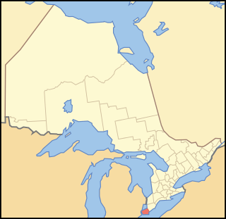
Windsor is a city in southwestern Ontario, Canada, on the south bank of the Detroit River directly across from Detroit, Michigan, United States. Geographically located within but administratively independent of Essex County, it is the southernmost city in Canada and marks the southwestern end of the Quebec City–Windsor Corridor. The city's population was 229,660 at the 2021 census, making it the third-most populated city in Southwestern Ontario, after London and Kitchener. This represents a 5.7 percent increase from Windsor's 2016 population census of 217,188. The Detroit–Windsor urban area is North America's most populous trans-border conurbation. Linking the Great Lakes Megalopolis, the Ambassador Bridge border crossing is the busiest commercial crossing on the Canada–United States border.
Essex County is a primarily rural county in Southwestern Ontario, Canada comprising seven municipalities: Amherstburg, Kingsville, Lakeshore, LaSalle, Leamington, Tecumseh and the administrative seat, Essex.

Tecumseh is a town in Essex County in Southwestern Ontario, Canada. It is on Lake St. Clair east of Windsor and had a population of roughly 23,300 as of the 2021 census according to Statistics Canada. It is part of the Windsor census metropolitan area, and is a part of the Windsor-Essex County region along with the towns of Amherstburg, Essex, Kingsville, LaSalle, and the municipalities of Lakeshore and Leamington. Tecumseh was originally a Franco-Ontarian settlement.
The E. C. Row Expressway is a municipal expressway in the city of Windsor, Ontario, Canada. It divides the city in half as it crosses it between the Ojibway Parkway in the west and Banwell Road in the east, a distance of 15.4 kilometres (9.6 mi). It was built between 1971 and 1983, reaching completion across the city on June 9, 1983. It was part of Highway 2 and Highway 18 until the province transferred ownership and responsibility for the route to the City of Windsor on April 1, 1997. In 2015, the westernmost 3 kilometres (1.9 mi) was significantly upgraded as part of the Highway 401 extension project. The freeway is named after Edgar Charles Row, the president of Chrysler Canada between 1951 and 1956.

Windsor—Tecumseh is a federal electoral district in Ontario, Canada, that has been represented in the House of Commons of Canada since 2004.

The Greater Essex County District School Board was created on January 1, 1998, with the amalgamation of the Windsor Board of Education and the Essex County Board of Education. The school board services families in both Windsor, Ontario and Essex County, Ontario in Canada.
Windsor's Department of Parks and Recreation maintains 3,000 acres (12 km2) of green space, 180 parks, 40 miles (64 km) of trails, 22 miles (35 km) of sidewalk, 60 parking lots, vacant lands, natural areas and forest cover within the City of Windsor, as well as the Bike Trails, Bike Lanes, and Bike-Friendly Streets.
The Ganatchio Trail is the second bike trail built in Windsor, Ontario, Canada. Construction on the trail started upon the closure of Clairview Avenue. The trail extends over 5.3 km, and passes through several neighbourhoods, including Riverside and Little River, and serves Sandpoint Beach and Stop 26 Beach and Park. It was the second major trail constructed, after the Riverfront Bike Trail, with extensions east towards Tecumseh built in stages. The trail has a posted speed limit of 20 km/h. The Riverfront and the Ganatchio Trails are wide enough for two cycle lanes in each direction.
The Roy A. Battagello River Walk Bike Trail is the current backbone of the "Windsor Loop" bike trail network in Windsor, Ontario. The bike trail travels from the foot of the Ambassador Bridge, to traffic lights at Riverside Drive and Lincoln Avenue. This makes the trail the second-longest trail in the City of Windsor, at 8.0 km.
The Little River Extension is one of the newest and busiest recreational trails in Windsor, Ontario, having been built in 1996. The trail is used mainly as a link between the large subdivision of Forest Glade, to Ganatchio Trail, Sandpoint Beach, Stop 26 Beach, and Lakeview Park And Marina. The trail has a posted speed limit of 20 kilometres per hour (12 mph).
The Devonwood Bike Trail is a fairly straight and flat bike trail in the southern end of the city of Windsor, Ontario. The path starts just south of E.C. Row Expressway at the intersection of Hallmark Avenue and Conservation Drive. The path has several short branches less than 100 m long to connect it to neighbouring cul-de-sacs, and passes through a couple parks. Its southern terminus is the end of the pavement as it enters the Essex Region Conservation Authority-controlled Devonwood Conservation Area, a heavily wooded animal and plant sanctuary. The trail also serves the Windsor Airport, Devonshire Mall, and the "Silver City" mall and theatre area via bike lanes on Calderwood Avenue and a paved trail along Walker Road.
Windsor, Ontario, has a very diverse population, and this diversity is shown in its many neighbourhoods. Windsor has twenty in all, ranging from rural farmland to densely built-up areas.
King's Highway 39, commonly referred to as Highway 39, was a provincially maintained highway in the Canadian province of Ontario. The 33.8-kilometre (21.0 mi)-long route connected Highway 3 in downtown Windsor with Highway 2 south of Belle River, travelling along the southern shoreline of Lake St. Clair. Highway 39 was established in 1934. By 1961, the Pike Creek Bypass was opened and Highway 39 was rerouted along it, with the former route briefly becoming Highway 39B. The route was renumbered as Highway 2 in 1970, retiring the designation from the provincial highway system. Highway 2 was itself decommissioned along the former route of Highway 39 on January 1, 1998, and transferred to Essex County and the City of Windsor. It was subsequently redesignated as Essex County Road 22.
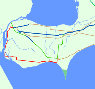
King's Highway 18, commonly referred to as Highway 18, was a provincially maintained highway in the Canadian province of Ontario, located entirely within Essex County. Since 1998, the majority of the former route has been known as Essex County Road 20. The route travelled at the southernmost point in Canada, along or near the shoreline of the Detroit River and Lake Erie between Windsor and Leamington, with Highway 3 as the terminus at both ends. The former route provides access to the communities of LaSalle, Amherstburg, Malden Centre, Harrow, Kingsville and Union.

King's Highway 3B, commonly referred to as Highway 3B, was a provincially maintained highway within Windsor, in the Canadian province of Ontario. Its purpose was to link Highway 3 and Highway 401 with the Detroit–Windsor tunnel and downtown Windsor. Highway 3B was routed along the city streets of Ouellette Avenue, Ouellette Place, Howard Avenue, and Dougall Avenue.
The Grand Marais Trail is a small bicycle trail that follows Turkey Creek in the middle of Windsor, Ontario. It starts off as a minor spur route, connecting the West Windsor Recreationway with Huron Church Road and the neighbourhood of South Windsor.
The Conseil scolaire catholique Providence is the French-language Catholic school board for southwestern Ontario, Canada. The Providence Catholic School Board includes 10,000 students in its 31 schools: 23 elementary schools and 8 high schools for the communities of Windsor-Essex, Chatham-Kent, Sarnia-Lambton, London/Middlesex, Oxford-Woodstock, Grey-Bruce and Huron-Perth. The board was previously known as the Conseil scolaire de district des écoles catholiques du Sud-Ouest (CSDÉCSO).
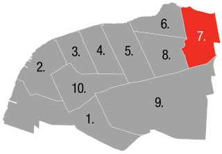
Ward 7 is a municipal ward in the east end of Windsor, Ontario, Canada. Its representation on Windsor City Council is currently Angelo Marignani. It contains that part of the city of Windsor east of the Little River and north of the E. C. Row Expressway. It covers the neighbourhoods of Forest Glade and East Riverside.
