Forest Grove | |
---|---|
Coordinates: 47°58′36″N94°13′53″W / 47.97667°N 94.23139°W Coordinates: 47°58′36″N94°13′53″W / 47.97667°N 94.23139°W | |
Country | United States |
State | Minnesota |
County | Koochiching |
Elevation | 1,365 ft (416 m) |
Time zone | UTC-6 (Central (CST)) |
• Summer (DST) | UTC-5 (CDT) |
ZIP code | 56660 |
Area code(s) | 218 |
GNIS feature ID | 656295 [1] |
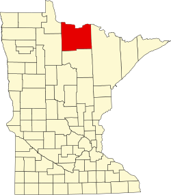
Forest Grove is an unincorporated community in Koochiching County, Minnesota, United States; located within the Pine Island State Forest. The community is located north of Mizpah and west of Gemmell, along Koochiching County Road 17 (CR 17).
U.S. Highway 71 and County Road 36 are also nearby. The center of Forest Grove is generally considered at the intersection of County Roads 17, 58, and 150.
Forest Grove is located within ZIP code 56660, based in Mizpah.
Forest Grove is located within Northome Unorganized Territory. Nearby places include Mizpah, Northome, Gemmell, and Kelliher. Forest Grove is located four miles north of Mizpah. Forest Grove is nine miles north of Northome and 69 miles southwest of International Falls.
The former township of Forest Grove, which was dissolved in 1950, had been located in the same vicinity as the community of Forest Grove.
Koochiching County is a county in the U.S. state of Minnesota. As of the 2010 census, the population was 13,311. Its county seat is International Falls. A portion of the Bois Forte Indian Reservation is in the county. A small part of Voyageurs National Park extends into its boundary, with Lake of the Woods County to its northwest.
Northome is a city located in the southwestern corner of Koochiching County, Minnesota, United States. The population was 200 at the 2010 census. The county seat is International Falls, about 70 miles (110 km) away.
Northome is an unorganized territory in Koochiching County, Minnesota, United States. The term "unorganized territory" is used by the United States Census Bureau to designate a portion of a county that is not included in any legally established minor civil division for the purpose of presenting statistical data. The population was 496 at the 2000 census.
Minnesota State Highway 1 is a state highway across northern Minnesota, United States, which runs from North Dakota Highway 54 (ND 54) at the North Dakota state line and continues east to its eastern terminus at MN 61 at the unincorporated community of Illgen City in Beaver Bay Township on the North Shore of Lake Superior. At 346 miles (557 km) in length, Highway 1 is the longest state route in Minnesota.
Craigville is an unincorporated community in Koochiching County, Minnesota, United States; located within the Koochiching State Forest.
Margie is an unincorporated community in Koochiching County, Minnesota, United States; located near Big Falls.
Alvwood is an unincorporated community in Alvwood Township, Itasca County, Minnesota, United States.
Bergville is an unincorporated community in Ardenhurst Township, Itasca County, Minnesota, United States; located within the Chippewa National Forest.
Lindford is an unincorporated community in Koochiching County, Minnesota, United States.
Silverdale is an unincorporated community in Koochiching County, Minnesota, United States; located in the southeast corner of the county.
Gemmell is an unincorporated community in Koochiching County, Minnesota, United States; located near Mizpah and Northome.
Wildwood is an unincorporated community in Koochiching County, Minnesota, United States; located within the Pine Island State Forest.
Pinetop is an unincorporated community in Koochiching County, Minnesota, United States; located within the Pine Island State Forest. The community is located east of Mizpah; and south of Gemmell; along Koochiching County Road 6.
Bramble is an unincorporated community in Koochiching County, Minnesota, United States; located in the southeast corner of the county.
Dora Lake is an unincorporated community in Kinghurst Township, Itasca County, Minnesota, United States; located within the Chippewa National Forest. The community is located near Wirt at the junction of Itasca County Roads 29 and 145.
Grattan is an unincorporated community in Grattan Township, Itasca County, Minnesota, United States.
Houpt is an unincorporated community in Nore Township, Itasca County, Minnesota, United States, located in the northwest corner of the county.
Orth is an unincorporated community in Nore Township, Itasca County, Minnesota, United States, located in the northwestern corner of the county.
Rosy is an unincorporated community in Third River Township, Itasca County, Minnesota, United States. The community is located northwest of Squaw Lake; near the junction of Itasca County Roads 32, 33, and 141.
Pomroy is an unincorporated community in Pomroy Township, Itasca County, Minnesota, United States.
This article about a location in Koochiching County, Minnesota is a stub. You can help Wikipedia by expanding it. |