Foresta, California

Last updated

Crane Creek
View of Yosemite Valley from Foresta - Flickr - daveynin.jpg
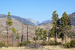
Yosemite Valley as seen from Foresta
USA California location map.svg
Red pog.svg
Foresta
Usa edcp location map.svg
Red pog.svg
Foresta
Coordinates: 37°41′55.60″N119°44′53.79″W / 37.6987778°N 119.7482750°W / 37.6987778; -119.7482750
Country Flag of the United States (23px).png  United States
State Flag of California.svg  California
County Mariposa
Area
[1]
  Total0.37 sq mi (0.96 km2)
  Land0.37 sq mi (0.96 km2)
  Water0.00 sq mi (0.00 km2)  0%
Elevation
[2]
4,420 ft (1,350 m)
Population
 (2020) [3]
  Total29
  Density78.38/sq mi (30.26/km2)
Time zone UTC-8 (Pacific (PST))
  Summer (DST) UTC-7 (PDT)
ZIP Code
FIPS code 06-24792
GNIS feature ID2830231 [2]

Foresta (formerly, McCauley and Opim) [4] is an unincorporated community and a census-designated place (CDP) in Mariposa County, California, within Yosemite National Park. [2]

Contents

History

The name comes from the Foresta Land Company, founded by A.B. Davis in 1913. [4] Davis built a resort at Foresta but abandoned it. [4] The Foresta area was subdivided and sold off to investors by the 1930s, but little construction at the site took place until electricity was extended to Foresta in 1951. Building of private residences mostly began at that time and continued until the early 1960s, with a campground built soon after. [5] Foresta now consists of homes for National Park Service, concessionaire, and Yosemite Institute employees, plus several vacation rentals. The community is located on the slopes surrounding Big Meadow, three miles off the Big Oak Flat Road. Many of the homes in the area burned in a 1990 wildfire. [6]

The Opim post office operated there from 1882 to 1884. [4]

Geography

It is located 2.25 miles (3.6 km) northeast of El Portal, [4] at an elevation of 4,420 feet (1,350 m). [2]

Demographics

Historical population
CensusPop.Note
2020 29
U.S. Decennial Census [7]
1850–1870 [8] [9] 1880-1890 [10]
1900 [11] 1910 [12] 1920 [13]
1930 [14] 1940 [15] 1950 [16]
1960 [17] 1970 [18] 1980 [19]
1990 [20] 2000 [21] 2010 [22]

The community was first listed as a census designated place under the name Crane Creek in the 2020 U.S. Census. [23] [24] The CDP's name was changed to Foresta by the U.S. Census Bureau in 2022. [25]

2020 census

Foresta CDP, California – Racial and ethnic composition
Note: the US Census treats Hispanic/Latino as an ethnic category. This table excludes Latinos from the racial categories and assigns them to a separate category. Hispanics/Latinos may be of any race.
Race / Ethnicity (NH = Non-Hispanic)Pop 2020 [24] % 2020
White alone (NH)2172.41%
Black or African American alone (NH)00.00%
Native American or Alaska Native alone (NH)00.00%
Asian alone (NH)00.00%
Pacific Islander alone (NH)00.00%
Other race alone (NH)13.45%
Mixed race or Multiracial (NH)620.69%
Hispanic or Latino (any race)13.45%
Total29100.00%

Related Research Articles

<span class="mw-page-title-main">Almanor, California</span> Census-designated place in California, United States

Almanor is a census-designated place (CDP) in Plumas County, California, United States. The population was 0 at the 2010 Census, but as of 2020, the population was reported as 3. Almanor is located 7 miles (11.3 km) south-southeast of Chester.

<span class="mw-page-title-main">Elm Creek, Texas</span> Census-designated place in Texas, United States

Elm Creek is a census-designated place (CDP) in Maverick County, Texas, United States. The population was 2,884 as of the 2020 census.

<span class="mw-page-title-main">Ahwahnee, California</span> Census-designated place in California, United States

Ahwahnee is a census-designated place in Madera County, California, United States. It is located 5.25 miles (8.4 km) west of Yosemite Forks, at an elevation of 2,326 feet (709 m). The population was 2,296 at the 2020 census.

<span class="mw-page-title-main">Coulterville, California</span> Census-designated place in California, United States

Coulterville is a census-designated place in Mariposa County, California, United States. It is located on Maxwell Creek 20 miles (32 km) northwest of Mariposa, at an elevation of 1,699 feet (518 m). Coulterville had a population of 115 at the 2020 census, down from 201 at the 2010 census, when the CDP covered a much greater area. It is a mining town located in the foothills of the Sierra Nevada. The ZIP Code is 95311. The community is inside area code 209.

Brooks is an unincorporated community and census-designated place (CDP) in Yolo County, California, located in the Capay Valley in the northwest of the county. Brooks' ZIP Code is 95606 and its area code 530. The Yocha Dehe Wintun Nation is headquartered in Brooks. The town is home to a large casino Cache Creek Casino Resort. It lies at an elevation of 341 feet.

<span class="mw-page-title-main">Bass Lake, California</span> Census-designated place in California, United States

Bass Lake is a census-designated place in Madera County, California, United States. It is located 4.5 miles (7.2 km) southeast of Yosemite Forks, at an elevation of 3,415 feet (1,041 m). The population was 575 at the 2020 census.

Bonadelle Ranchos is an unincorporated community and census-designated place (CDP) in Madera County, California, United States. It lies at an elevation of 338 feet (103 m). As of the 2020 census, it had a population of 5,497. Prior to 2020, the community was part of the Bonadelle Ranchos-Madera Ranchos CDP.

<span class="mw-page-title-main">Mount Bullion, Mariposa County, California</span> Unincorporated community in California, United States

Mount Bullion is an unincorporated community and census-designated place (CDP) in Mariposa County, California, United States. As of the 2020 United States census, it had a population of 154.

Centerville is an unincorporated community and census-designated place (CDP) in Shasta County, California, United States. Centerville is 6.5 miles (10.5 km) southwest of Redding.

Sugarloaf Mountain Park is a former census-designated place (CDP) in Tulare County, California. Sugarloaf Mountain Park sits at an elevation of 5,991 feet (1,826 m). The CDP was first listed in the 2010 U.S. Census although with zero population. The CDP was deleted prior to the 2020 U.S. Census.

Evergreen is a census-designated place (CDP) in Starr County, Texas, United States. It is a new CDP, formed from part of the Roma Creek CDP prior to the 2010 census, with a population of 73.

Ramos is a census-designated place (CDP) in Starr County, Texas, United States. It is a new CDP, formed from part of the Roma Creek CDP prior to the 2010 census, with a population of 116.

Amador Pines is an unincorporated community and census-designated place (CDP) in Amador County, California, United States. It is located along California State Route 88, bordered to the south by Buckhorn and to the west by Lockwood. The Census Bureau first designated it as a CDP prior to the 2020 census for statistical purposes.

Cedar Flat is a census-designated place (CDP) in eastern Placer County, California, United States. It is located on the northwest shore of Lake Tahoe, between Carnelian Bay to the northeast and Dollar Point to the southwest. It was first listed as a CDP prior to the 2020 census.

Beaver Creek is an unincorporated community and census-designated place (CDP) in Burleson County, Texas, United States. It was first listed as a CDP in the 2020 census with a population of 910.

Cade Lakes is an unincorporated community and census-designated place (CDP) in Burleson County, Texas, United States. It was first listed as a CDP in the 2020 census with a population of 507.

Bear Creek Ranch is a planned community and census-designated place (CDP) in Dallas County, Texas, United States. It was first listed as a CDP in the 2020 census with a population of 1,787.

Benton Park is a census-designated place (CDP) in Kern County, California. Although it is designated by the census as its own place, it is functionally a neighborhood of Bakersfield.

East Niles is an unincorporated community and census-designated place (CDP) in Kern County, California. The CDP is within the Bakersfield's census county division, and borders the city of Bakersfield to the north and the southwest, Bakersfield Country Club to the northwest, Hillcrest and Potomac Park to the west, and Fairfax to the south.

Highlands is an unincorporated community and census designated place (CDP) in San Mateo County. As of the 2020 U.S. Census, the population was 2,359.

References

  1. "2022 U.S. Gazetteer Files: California". United States Census Bureau. Retrieved July 15, 2022.
  2. 1 2 3 4 "Foresta Census Designated Place". Geographic Names Information System . United States Geological Survey, United States Department of the Interior.
  3. "P1. Race – Crane Creek CDP, California: 2020 DEC Redistricting Data (PL 94-171)". U.S. Census Bureau. Retrieved July 15, 2022.
  4. 1 2 3 4 5 Durham, David L. (1998). California's Geographic Names: A Gazetteer of Historic and Modern Names of the State. Clovis, Calif.: Word Dancer Press. p. 773-774. ISBN   1-884995-14-4.
  5. Greene, Linda Wedel (1987). Yosemite: The Park and Its Resources, Volume 2 of 3. Washington, DC: US Department of the Interior, National Park Service. pp. 932–937.
  6. Final Yosemite Valley Plan: Supplemental Environmental Impact Statement. Yosemite National Park, CA: National Park Service. 2000. pp. 3–147.
  7. "Decennial Census by Decade". US Census Bureau.
  8. "1870 Census of Population - Population of Civil Divisions less than Counties - California - Almeda County to Sutter County" (PDF). United States Census Bureau .
  9. "1870 Census of Population - Population of Civil Divisions less than Counties - California - Tehama County to Yuba County" (PDF). United States Census Bureau .
  10. "1890 Census of Population - Population of California by Minor Civil Divisions" (PDF). United States Census Bureau .
  11. "1900 Census of Population - Population of California by Counties and Minor Civil Divisions" (PDF). United States Census Bureau .
  12. "1910 Census of Population - Supplement for California" (PDF). United States Census Bureau .
  13. "1920 Census of Population - Number of Inhabitants - California" (PDF). United States Census Bureau .
  14. "1930 Census of Population - Number and Distribution of Inhabitants - California" (PDF). United States Census Bureau .
  15. "1940 Census of Population - Number of Inhabitants - California" (PDF). United States Census Bureau .
  16. "1950 Census of Population - Number of Inhabitants - California" (PDF). United States Census Bureau .
  17. "1960 Census of Population - General population Characteristics - California" (PDF). United States Census Bureau .
  18. "1970 Census of Population - Number of Inhabitants - California" (PDF). United States Census Bureau .
  19. "1980 Census of Population - Number of Inhabitants - California" (PDF). United States Census Bureau .
  20. "1990 Census of Population - Population and Housing Unit Counts - California" (PDF). United States Census Bureau .
  21. "2000 Census of Population - Population and Housing Unit Counts - California" (PDF). United States Census Bureau .
  22. "2010 Census of Population - Population and Housing Unit Counts - California" (PDF). United States Census Bureau .
  23. "2020 Geography Changes". United States Census Bureau.
  24. 1 2 "P2: Hispanic or Latino, and Not Hispanic or Latino by Race – 2020: DEC Redistricting Data (PL 94-171) - Crane Creek CDP, California". United States Census Bureau.
  25. "2022 Geography Changes". United States Census Bureau .