
Camden County is a county located in the U.S. State of North Carolina. As of the 2020 census, the population was 10,335, making it the fourth-least populous county in North Carolina. Its county seat is Camden. Camden County is part of the Elizabeth City, NC Micropolitan Statistical Area, which is also included in the Virginia Beach-Norfolk, VA-NC Combined Statistical Area.

Ray County is a county located in the northwestern portion of the U.S. state of Missouri and is part of the Kansas City metropolitan area. As of the 2020 census, the population was 23,158. Its county seat is Richmond. The county was organized November 16, 1820 and named for John Ray, a Missouri state legislator and member of the first state Constitutional Convention.

Miller County is a county located in the U.S. state of Missouri. As of the 2020 United States census, the population was 24,722. Its county seat is Tuscumbia. The county was organized February 6, 1837 and named for John Miller, former U.S. Representative and Governor of Missouri.

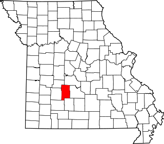
Laclede County is a county located in the U.S. state of Missouri. As of the 2010 census, the population was 35,571. Its county seat is Lebanon. The county was organized February 24, 1849, and was named after Pierre Laclède, founder of St. Louis.
Dallas County is a county located in the U.S. state of Missouri. As of the 2010 census, the population was 16,777. Its county seat is Buffalo. The county was organized in 1842 as Niangua County and then renamed in 1844 for George M. Dallas, who served as Vice President under James K. Polk.

Camden County is a county located in the U.S. state of Missouri. As of the 2020 Census, the population was 42,745. Its county seat is Camdenton. The county was organized on January 29, 1841, as Kinderhook County and renamed Camden County in 1843 after Charles Pratt, 1st Earl Camden, Lord Chancellor of the United Kingdom and leader of the British Whig Party. Camden County is also the primary setting of the Netflix show Ozark.

Camden is a city in and the county seat of Ouachita County in the south-central part of the U.S. state of Arkansas. The city is located about 100 miles south of Little Rock. Situated on bluffs overlooking the Ouachita River, the city developed because of the river. The recorded history began in 1782 when a Spanish military post was established on the site of an old French trading post called Écore à Fabri. When Ouachita County was formed in 1842, American settlers changed the name to Camden. The city became an important port during the steamboat era when Camden became known as the “Queen City” of the Ouachita. In 1864, Camden became the unintended focus of the Red River Campaign, a major Civil War effort resulting in several significant battles.
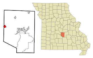
Camdenton is a city in and the county seat of Camden County, Missouri, United States. Its population was 3,718 at the 2010 census. The city is enveloped by the Lower Niangua arm of the Lake of the Ozarks and serves as a popular trade point for visitors to the area.

Climax Springs was a village in Camden County, Missouri, United States. The population was 124 at the 2010 census.

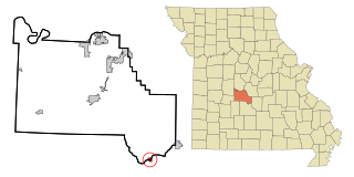
Linn Creek is a city in Camden County, Missouri, United States. The population was 216 at the 2020 census.

Macks Creek is an unincorporated community and census-designated place in southwest Camden County, Missouri, United States. The population was 244 at the 2010 census.

Laurie is a village in southern Morgan and northern Camden counties, Missouri, United States. The population was 945 at the 2010 census.
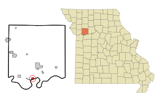
Camden is a city in southern Ray County, Missouri, and part of the Kansas City metropolitan area within the United States. The population was 175 at the 2020 census.

Osage Beach is a city in Camden and Miller counties in the U.S. state of Missouri. Most of the city is in Camden County, while a small eastern sliver is in Miller County. The population was 4,351 at the 2010 census.
Richland is a city in Camden, Laclede, and Pulaski counties in the U.S. state of Missouri. The population was 1,863 at the 2010 census.
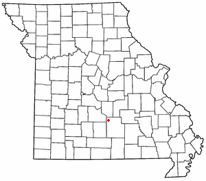
Stoutland is a village in Camden and Laclede counties in the U.S. state of Missouri. The population was 192 at the 2010 census.
Sunrise Beach is a village in Camden and Morgan counties in the U.S. state of Missouri. The population was 431 at the 2010 census.
Plato is an incorporated village in northwestern Texas County, Missouri, United States. It is located approximately 20 miles northwest of Houston and 10 miles south of Fort Leonard Wood on Route 32. The population was 82 at the 2020 census.
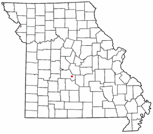
Montreal is an unincorporated community in southeast Camden County, Missouri, United States. It is located approximately eight miles east-southeast of Camdenton and 12 miles northwest of Richland on Route 7.

