Stoutland, Missouri

Last updated

Stoutland, Missouri
Camden County Missouri Incorporated and Unincorporated areas Stoutland Highlighted.svg
Location of Stoutland, Missouri
Coordinates: 37°48′49″N92°30′51″W / 37.81361°N 92.51417°W / 37.81361; -92.51417
Country United States
State Missouri
Counties Camden, Laclede
Area
[1]
  Total0.60 sq mi (1.57 km2)
  Land0.60 sq mi (1.57 km2)
  Water0.00 sq mi (0.00 km2)
Elevation
[2]
1,171 ft (357 m)
Population
 (2020)
  Total209
  Density346.03/sq mi (133.53/km2)
Time zone UTC-6 (Central (CST))
  Summer (DST) UTC-5 (CDT)
ZIP code
65567
Area code 417
FIPS code 29-71008 [3]
GNIS feature ID2395979 [2]

Stoutland is a city in Camden and Laclede counties in the U.S. state of Missouri. [4] The population was 192 at the 2010 census. [5]

Contents

History

The first settlement at Stoutland was made in 1869. [6] A post office called Stoutland has been in operation since 1870. [7] The village was named after Captain Stout, a railroad official. [8]

Geography

Stoutland is located on the Camden-Laclede county line at the intersection of Missouri routes T and F. Richland is approximately 6.5 miles to the northeast in Pulaski County and Sleeper in about 5.5 miles to the southwest in Laclede County. Bear Creek flows past about two miles to the southeast and the Gasconade River is one mile further south. [9]

According to the United States Census Bureau, the city has a total area of 0.60 square miles (1.55 km2), all land. [10]

Demographics

Historical population
CensusPop.Note
1920 300
1930 214−28.7%
1940 24414.0%
1950 192−21.3%
1960 172−10.4%
1970 20519.2%
1980 28639.5%
1990 207−27.6%
2000 177−14.5%
2010 1928.5%
2020 2098.9%
U.S. Decennial Census [11]

2010 census

As of the census [12] of 2010, there were 192 people, 93 households, and 50 families living in the city. The population density was 320.0 inhabitants per square mile (123.6/km2). There were 104 housing units at an average density of 173.3 per square mile (66.9/km2). The racial makeup of the city was 99.0% White and 1.0% from other races. Hispanic or Latino of any race were 5.7% of the population.

There were 93 households, of which 21.5% had children under the age of 18 living with them, 37.6% were married couples living together, 11.8% had a female householder with no husband present, 4.3% had a male householder with no wife present, and 46.2% were non-families. 38.7% of all households were made up of individuals, and 23.7% had someone living alone who was 65 years of age or older. The average household size was 2.06 and the average family size was 2.74.

The median age in the city was 46.4 years. 16.1% of residents were under the age of 18; 6.8% were between the ages of 18 and 24; 24% were from 25 to 44; 30.1% were from 45 to 64; and 22.9% were 65 years of age or older. The gender makeup of the city was 48.4% male and 51.6% female.

2000 census

As of the census [3] of 2000, there were 177 people, 81 households, and 52 families living in the village. The population density was 296.7 inhabitants per square mile (114.6/km2). There were 97 housing units at an average density of 162.6 per square mile (62.8/km2). The racial makeup of the village was 95.48% White, and 4.52% from two or more races.

There were 81 households, out of which 24.7% had children under the age of 18 living with them, 49.4% were married couples living together, 11.1% had a female householder with no husband present, and 35.8% were non-families. 34.6% of all households were made up of individuals, and 8.6% had someone living alone who was 65 years of age or older. The average household size was 2.19 and the average family size was 2.81.

In the village, the population was spread out, with 20.9% under the age of 18, 5.6% from 18 to 24, 29.4% from 25 to 44, 23.7% from 45 to 64, and 20.3% who were 65 years of age or older. The median age was 40 years. For every 100 females, there were 80.6 males. For every 100 females age 18 and over, there were 84.2 males.

The median income for a household in the village was $31,250, and the median income for a family was $41,875. Males had a median income of $30,500 versus $28,214 for females. The per capita income for the village was $15,476. About 5.1% of families and 5.5% of the population were below the poverty line, including 6.3% of those under the age of eighteen and 16.7% of those 65 or over.

Education

Stoutland R-II School District operates one elementary school and Stoutland High School. [13]

Stoutland has a public library, a branch of the Camden County Library District. [14]

Related Research Articles

<span class="mw-page-title-main">Laclede County, Missouri</span> County in Missouri, United States

Laclede County is a county located in the U.S. state of Missouri. As of the 2020 census, the population was 36,039. Its county seat is Lebanon. The county was organized February 24, 1849, and was named after Pierre Laclède, founder of St. Louis.

<span class="mw-page-title-main">Dallas County, Missouri</span> County in Missouri, United States

Dallas County is a county located in the U.S. state of Missouri. As of the 2010 census, the population was 17,071. Its county seat is Buffalo. The county was organized in 1842 as Niangua County and then renamed in 1844 for George M. Dallas, who served as Vice President under James K. Polk.

<span class="mw-page-title-main">Camden County, Missouri</span> County in Missouri, United States

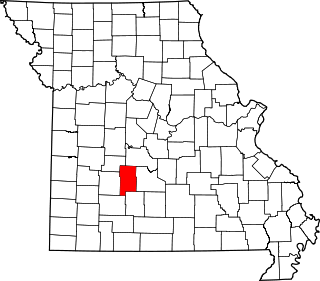
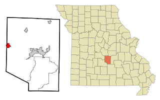
Camden County is a county located in the U.S. state of Missouri. As of the 2020 Census, the population was 42,745. Its county seat is Camdenton. The county was organized on January 29, 1841, as Kinderhook County and renamed Camden County in 1843 after Charles Pratt, 1st Earl Camden, Lord Chancellor of the United Kingdom and leader of the British Whig Party. Camden County is also the primary setting of the Netflix show Ozark.

<span class="mw-page-title-main">Camden, Michigan</span> Village in Michigan, United States

Camden is a village in Hillsdale County in the U.S. state of Michigan. The population was 496 at the 2020 census. The village is located within Camden Township.

<span class="mw-page-title-main">Village of Four Seasons, Missouri</span> Village in Missouri, United States

Village of Four Seasons is a village in Camden County, Missouri, United States. The population was 2,217 at the 2010 census. The village is situated on the shores of Lake of the Ozarks and is a popular tourist destination along with the other communities in the area.

<span class="mw-page-title-main">West Line, Missouri</span> Village in Missouri, United States

West Line is a village in Cass County, Missouri. The population was 97 at the 2010 census. It is part of the Kansas City metropolitan area.

<span class="mw-page-title-main">Conway, Missouri</span> City in Missouri, United States

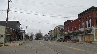
Conway is a city in Laclede County, Missouri, United States. The population was 788 at the 2010 census. Conway is located 15 miles (24 km) southwest of Lebanon.

<span class="mw-page-title-main">Lebanon, Missouri</span> City in Missouri, United States

Lebanon is a city in and the county seat of Laclede County in Missouri. The population was 14,474 at the time of the 2010 census. It is the county seat of Laclede County. The Lebanon Micropolitan Statistical Area consists of Laclede County.

<span class="mw-page-title-main">Evergreen, Missouri</span> Village in Missouri, United States

Evergreen is a village in Laclede County, Missouri, United States. The population was 28 at the 2010 census. It was named Twin Bridges at the 2000 census.

<span class="mw-page-title-main">Laclede, Missouri</span> City in Missouri, United States

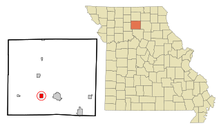
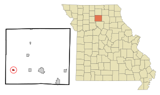
Laclede is a city in Linn County, Missouri. The population was 305 at the 2020 census, down from 345 in 2010.

<span class="mw-page-title-main">Linneus, Missouri</span> City in Missouri, United States

Linneus is a small city in Linn County, Missouri, United States. The population was 281 at the 2020 census. It is the county seat of Linn County.

<span class="mw-page-title-main">Meadville, Missouri</span> City in Missouri, United States

Meadville is a city in southwest Linn County, Missouri, United States. The population was 415 at the 2020 census.

<span class="mw-page-title-main">Laurie, Missouri</span> City in Missouri, United States

Laurie is a city in southern Morgan and northern Camden counties, Missouri, United States. The population was 945 at the 2010 census.

<span class="mw-page-title-main">Camden, Missouri</span> City in Missouri, United States

Camden is a city in southern Ray County, Missouri, and part of the Kansas City metropolitan area within the United States. The population was 175 at the 2020 census.

<span class="mw-page-title-main">Nelson, Missouri</span> City in Missouri, United States

Nelson is a city in Saline County, Missouri, United States. The population was 152 at the 2020 census.

<span class="mw-page-title-main">Maplewood, Missouri</span> City in Missouri, United States

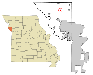
Maplewood is an inner-ring suburb of St. Louis, located in St. Louis County, Missouri, United States.

<span class="mw-page-title-main">Phillipsburg, Missouri</span> Village in Missouri, United States

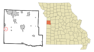
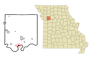
Phillipsburg is a village in Laclede County, Missouri, United States. The population was 202 at the 2010 census.

<span class="mw-page-title-main">Camden Point, Missouri</span> City in Missouri, United States

Camden Point is a city in Platte County, Missouri, United States and is part of the Kansas City metropolitan area. The population was 474 at the 2010 census.

<span class="mw-page-title-main">Richland, Missouri</span> City in Missouri, United States

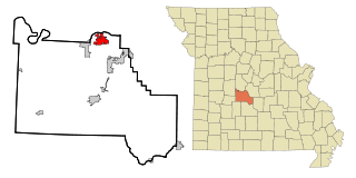
Richland is a city in Camden, Laclede, and Pulaski counties in the U.S. state of Missouri. The population was 1,863 at the 2010 census.

Sunrise Beach is a village in Camden and Morgan counties in the U.S. state of Missouri. The population was 431 at the 2010 census.

References

  1. "ArcGIS REST Services Directory". United States Census Bureau. Retrieved August 28, 2022.
  2. 1 2 U.S. Geological Survey Geographic Names Information System: Stoutland, Missouri
  3. 1 2 "U.S. Census website". United States Census Bureau . Retrieved January 31, 2008.
  4. "Classification of Municipalities". 2021-2022 Official Manual, State of Missouri (PDF). 2021.{{cite book}}: |work= ignored (help)
  5. "Profile of General Population and Housing Characteristics: 2010 Demographic Profile Data (DP-1): Stoutland city, Missouri". United States Census Bureau . Retrieved March 6, 2012.
  6. Campbell, Robert Allen (1875). Campbell's Gazetteer of Missouri. R. A. Campbell. p.  101.
  7. "Post Offices". Jim Forte Postal History. Retrieved September 8, 2016.
  8. "Camden County Place Names, 1928–1945 (archived)". The State Historical Society of Missouri. Archived from the original on June 24, 2016. Retrieved September 8, 2016.{{cite web}}: CS1 maint: bot: original URL status unknown (link)
  9. Missouri Atlas & Gazetteer, DeLorme, 1st ed., 1998, p. 45 ISBN   0899332242
  10. "US Gazetteer files 2010". United States Census Bureau. Archived from the original on January 25, 2012. Retrieved July 8, 2012.
  11. "Census of Population and Housing". Census.gov. Retrieved June 4, 2015.
  12. "U.S. Census website". United States Census Bureau . Retrieved July 8, 2012.
  13. "Stoutland R-Ii School District". Greatschools. Retrieved March 18, 2018.
  14. "Hours/Location". Camden County Library District. Archived from the original on March 18, 2018. Retrieved March 18, 2018.