Village of Four Seasons, Missouri

Last updated

Village of Four Seasons, Missouri
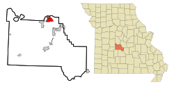
Camden County Missouri Incorporated and Unincorporated areas Village of Four Seasons Highlighted.svg
Location of Village of Four Seasons, Missouri
Coordinates: 38°12′4″N92°42′56″W / 38.20111°N 92.71556°W / 38.20111; -92.71556
Country United States
State Missouri
County Camden
Area
[1]
  Total4.71 sq mi (12.20 km2)
  Land4.65 sq mi (12.03 km2)
  Water0.07 sq mi (0.17 km2)
Elevation
[2]
738 ft (225 m)
Population
 (2020)
  Total2,383
  Density512.91/sq mi (198.04/km2)
Time zone UTC-6 (Central (CST))
  Summer (DST) UTC-5 (CDT)
ZIP code
65049
Area code 573
FIPS code 29-76157 [3]
GNIS feature ID1669605 [2]
Website https://villageoffourseasons.com/

Village of Four Seasons is a village in Camden County, Missouri, United States. The population was 2,217 at the 2010 census. The village is situated on the shores of Lake of the Ozarks and is a popular tourist destination along with the other communities in the area.

Contents

Geography

Village of Four Seasons is located at 38°12′4″N92°42′56″W / 38.20111°N 92.71556°W / 38.20111; -92.71556 (38.201086, −92.715556). [4]

According to the United States Census Bureau, the village has a total area of 4.59 square miles (11.89 km2), of which 4.52 square miles (11.71 km2) is land and 0.07 square miles (0.18 km2) is water. [5]

Demographics

Historical population
CensusPop.Note
1990 805
2000 1,49385.5%
2010 2,21748.5%
2020 2,3837.5%
U.S. Decennial Census [6]

2010 census

At the 2010 census, [7] there were 2,217 people, 966 households and 701 families residing in the village. The population density was 490.5 inhabitants per square mile (189.4/km2). There were 2,606 housing units at an average density of 576.5 per square mile (222.6/km2). The racial makeup of the village was 97.6% White, 0.9% African American, 0.5% Native American, 0.4% Asian, 0.2% from other races, and 0.5% from two or more races. Hispanic or Latino of any race were 1.1% of the population.

There were 966 households, of which 26.4% had children under the age of 18 living with them, 63.7% were married couples living together, 5.4% had a female householder with no husband present, 3.5% had a male householder with no wife present, and 27.4% were non-families. 21.9% of all households were made up of individuals, and 7.6% had someone living alone who was 65 years of age or older. The average household size was 2.30 and the average family size was 2.65.

The median age was 47.3 years. 20.2% of residents were under the age of 18; 4.1% were between the ages of 18 and 24; 23.1% were from 25 to 44; 32.4% were from 45 to 64; and 20.3% were 65 years of age or older. The gender makeup of the village was 48.8% male and 51.2% female.

2000 census

At the 2000 census, [3] there were 1,493 people, 641 households and 496 families residing in the village. The population density was 334.2 inhabitants per square mile (129.0/km2). There were 2,025 housing units at an average density of 453.3 per square mile (175.0/km2). The racial makeup was 98.19% White, 0.13% African American, 0.07% Native American, 0.33% Asian, 0.20% from other races, and 1.07% from two or more races. Hispanic or Latino of any race were 0.94% of the population.

There were 641 households, of which 23.2% had children under the age of 18 living with them, 68.0% were married couples living together, 7.0% had a female householder with no husband present, and 22.6% were non-families. 18.3% of all households were made up of individuals, and 5.1% had someone living alone who was 65 years of age or older. The average household size was 2.33 and the average family size was 2.62.

19.6% of the population were under the age of 18, 6.3% from 18 to 24, 20.9% from 25 to 44, 36.0% from 45 to 64, and 17.3% who were 65 years of age or older. The median age was 47 years. For every 100 females, there were 91.4 males. For every 100 females age 18 and over, there were 96.2 males.

The median household income was $59,063 and the median family incomewas $60,714. Males had a median income of $42,250 and females $25,417. The per capita income was $36,593. About 8.7% of families and 10.7% of the population were below the poverty line, including 28.1% of those under age 18 and 1.6% of those age 65 or over.
Related Research Articles

<span class="mw-page-title-main">Lakes, Alaska</span> Former CDP in Alaska, United States

Lakes was a census-designated place (CDP) in Matanuska-Susitna Borough, Alaska, United States. It was split in two CDPs for 2020 Census purposes: North Lakes and South Lakes. The area is part of the Anchorage, Alaska Metropolitan Statistical Area. At the 2010 census the population was 8,364, up from 6,706 in 2000.

<span class="mw-page-title-main">Spencer, Indiana</span> Town in Indiana, United States

Spencer is a town in Washington Township, Owen County, in the U.S. state of Indiana. The population was 2,217 at the 2010 census. It is the county seat of Owen County.

<span class="mw-page-title-main">Colesburg, Iowa</span> City in Iowa, United States

Colesburg is a city in Delaware County, Iowa, United States. The population was 386 at the time of the 2020 census.

<span class="mw-page-title-main">Sloan, Iowa</span> City in Iowa, United States

Sloan is a city in Woodbury County, Iowa, United States. It is part of the Sioux City, IA–NE–SD Metropolitan Statistical Area. The population was 1,042 at the time of the 2020 census.

<span class="mw-page-title-main">Kechi, Kansas</span> City in Sedgwick County, Kansas

Kechi is a city in Sedgwick County, Kansas, United States, and a suburb of Wichita. As of the 2020 census, the population of the city was 2,217.

<span class="mw-page-title-main">Moorland, Kentucky</span> City in Kentucky, United States

Moorland is a home rule-class city in Jefferson County, Kentucky, United States. The population was 431 as of the 2010 census.

<span class="mw-page-title-main">Provencal, Louisiana</span> Village in Louisiana, United States

Provencal is a village in Natchitoches Parish, Louisiana, United States. The population was 611 at the 2010 census. It is part of the Natchitoches Micropolitan Statistical Area.

<span class="mw-page-title-main">Galestown, Maryland</span> Town in Maryland, United States

Galestown is a town in Dorchester County, Maryland, United States. The population was 138 at the 2010 census.

<span class="mw-page-title-main">Muskegon Heights, Michigan</span> City in Michigan, United States

Muskegon Heights is a city in Muskegon County in the U.S. state of Michigan. The population was 9,985 at the 2020 census.

<span class="mw-page-title-main">Gibraltar, Michigan</span> City in Michigan, United States

Gibraltar is a city in Wayne County in the U.S. state of Michigan. The population was 4,656 at the 2010 census.

<span class="mw-page-title-main">Miramiguoa Park, Missouri</span> Village in Missouri, United States

Miramiguoa Park is a village in Franklin County, Missouri, United States. The population was 120 at the 2010 census.

<span class="mw-page-title-main">Sycamore Hills, Missouri</span> Village in Missouri, United States

Sycamore Hills is a village in St. Louis County, Missouri, United States. The population is 560 at the 2020 census.

<span class="mw-page-title-main">Geneva, Nebraska</span> City in Nebraska, United States

Geneva is a city in, and the county seat of, Fillmore County, Nebraska, United States. The population was 2,217 at the 2010 census.

<span class="mw-page-title-main">Bethlehem, West Virginia</span> Village in West Virginia, United States

Bethlehem is a village in Ohio County, West Virginia, United States. It is part of the Wheeling, West Virginia Metropolitan Statistical Area. The population was 2,499 at the 2010 census.

<span class="mw-page-title-main">Bellevue, Wisconsin</span> Village in Wisconsin, United States

Bellevue is a village in Brown County, Wisconsin. It was a town until incorporating as a village on February 14, 2003. The population was 15,935 at the time of the 2020 census. Bellevue is part of the Green Bay metropolitan area. Bellevue sits around 4.34 miles (6.99 km) east from central Green Bay.

<span class="mw-page-title-main">Kekoskee, Wisconsin</span> Village in Wisconsin, United States

Kekoskee is a village in Dodge County, Wisconsin, United States. The population was 161 at the 2010 census.

<span class="mw-page-title-main">Lake Delton, Wisconsin</span> Village in Wisconsin, United States

Lake Delton is a village located on the Wisconsin River in Sauk County, Wisconsin, United States. The population was 3,501 at the 2020 census. Lake Delton, along with the nearby Wisconsin Dells, is a resort area and a center for tourism in the upper Midwest. Lake Delton is included in the Baraboo Micropolitan Area which comprises part of the larger Madison Combined Statistical Area.

<span class="mw-page-title-main">Verona, Ohio</span> Village in Ohio, United States

Verona is a village in Montgomery and Preble counties in the U.S. state of Ohio. The population was 403 at the 2020 census. It is part of the Dayton Metropolitan Statistical Area.

<span class="mw-page-title-main">Dorchester, Wisconsin</span> Village in Wisconsin, United States

Dorchester is a village in Clark and Marathon counties in the U.S. state of Wisconsin, along the 45th parallel. It is part of the Wausau, Wisconsin Metropolitan Statistical Area. The population was 876 at the 2010 census. Of this, 871 were in Clark County, and only 5 were in Marathon County.

<span class="mw-page-title-main">Black Earth, Wisconsin</span> Village in Wisconsin, United States

Black Earth is a village in Dane County, Wisconsin, United States. The population was 1,338 at the 2010 census. The village is located within the Town of Black Earth. It is part of the Madison Metropolitan Statistical Area.

References

  1. "ArcGIS REST Services Directory". United States Census Bureau. Retrieved August 28, 2022.
  2. 1 2 U.S. Geological Survey Geographic Names Information System: Village of Four Seasons, Missouri
  3. 1 2 "U.S. Census website". United States Census Bureau . Retrieved January 31, 2008.
  4. "US Gazetteer files: 2010, 2000, and 1990". United States Census Bureau. February 12, 2011. Retrieved April 23, 2011.
  5. "US Gazetteer files 2010". United States Census Bureau. Archived from the original on January 12, 2012. Retrieved July 8, 2012.
  6. "Census of Population and Housing". Census.gov. Retrieved June 4, 2015.
  7. "U.S. Census website". United States Census Bureau . Retrieved July 8, 2012.