Saint Annie, Missouri

Last updated

Saint Annie, Missouri
USA Missouri location map.svg
Red pog.svg
Saint Annie
Usa edcp location map.svg
Red pog.svg
Saint Annie
Coordinates: 37°38′01″N92°13′10″W / 37.63361°N 92.21944°W / 37.63361; -92.21944
Country United States
State Missouri
County Laclede
Elevation
[1]
1,125 ft (343 m)
Time zone UTC-6 (Central (CST))
  Summer (DST) UTC-5 (CDT)
Area code 417
GNIS feature ID740600 [1]

Saint Annie was an unincorporated community in southwest Pulaski County, Missouri, United States. The community was about a mile south of Cookville, but the post office moved depending on where the postmaster lived. The last active post office was located on Webster Drive just west of the Laclede-Texas county line approximately five miles north of Lynchburg. The community of Winnipeg is about 3 1/2 miles to the northwest. [2] [1]

History

The oldest records place the unincorporated community of Saint Annie in southwest Pulaski County close to the Texas County line, Township 34 Range 12. [3] [4] This was in the southern portion of the Roubidoux township of Pulaski County. [5] The community was only one mile south of Cookville [6] [7] [8]

A post office at Saint Annie was established in 1867 with George Hume as postmaster. It is suggested that it was named after a diminutive expression for Mexican General Antonio Lopez de Santa Anna by Missouri Mexican War veterans. [8] [9] The post office was later moved to Laclede County, southwest of present day Ft. Leonard Wood, but retained the name [8] .

By the 1890s the Saint Annie community had both a school and a church. The Saint Annie Baptist Church was organized in 1891 with T. H. Bollenger as the first pastor. This new church was organized in November, 1891, with eleven constituent members. [10] Other early pastors included W. H. Howell - 1892-1893, J.N. Manes – 1894, G. L. Shockley – 1895, J. J. Watts – 1896, and A. R. Fetterhoff. [11] The Pulaski County Association of Baptist Churches held its annual meeting with the St. Annie church in 1895. The annual minutes record: “Cookville, Mo., August 2, 1895. The Pulaski County Association of Baptist Churches met this day in its twenty-fifth annual session with the St. Annie church in the grove near St. Annie School House, Pulaski County, Mo.” [12] During that 1895 meeting, A. J. Riddle and James Roberson were set apart as deacons of the St. Annie Church, the church having previously ordered said ordination. [13] The association would again meet at Saint Annie in 1911. [14]

The Saint Annie schoolhouse was about a mile distant from the church and was being used to educate children by at least 1893 with George Lane, Sr. as the teacher. [15] A neighboring post office called Bend, located along the Texas and Laclede county line, was discontinued in March 1886 and merged into the Saint Annie Post Office of which Christopher Myers was then postmaster. In 1895 the position of postmaster of Saint Annie moved from Christopher Myers to Ben Crismon who owned the farm adjoining the farms of former Bend post masters Hiram King and Samuel Bradford. [16] For the final 36 years of the existence of the Saint Annie Post office it was located in Laclede County in the home of Ben Crismon about six miles east of Nebo. The Crismon farm was halfway between the post office at Plato and the post office at Cookville along the route on Roubidoux Creek. The Plato and Cookville offices were about six miles in either direction. [17] The Saint Annie post office was discontinued on July 15, 1930 and sent to Cookville. [18]

In 1930 the Gulf Oil Company was building a pumping station for a new pipeline near the Crismon farm on what is now U Highway in Laclede County. The community that developed at the pump station which included several homes, a store, an auto repair shop, and the school known as Blackbird School was known as Gulf City and should not be confused with Saint Annie. Both the Saint Annie church and school were on land in Pulaski County that was taken by the government to form Fort Leonard Wood. The Saint Annie cemetery was moved by the United States Army to the Bloodland Cemetery, also on Fort Leonard Wood. The Saint Annie Baptist Church "owned their own church building and functioned as a church until the Fort took it and the money that the Fort paid was used to buy the Pulaski County Baptist camp. [19] ” The bell from the church was placed on the lawn of the Pulaski County Courthouse in Waynesville.  The brand new Saint Annie School building, which had just been completed, was demolished by the military. The remains of the foundation of that school building and the nearby cemetery of the Macedonia Christian Church are the only visible traces left of the St Annie community.

Related Research Articles

<span class="mw-page-title-main">Pulaski County, Missouri</span> County in Missouri, United States

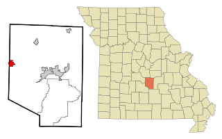
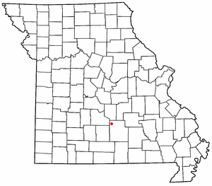
Pulaski County is a county located in the U.S. state of Missouri. As of the 2020 census, the population was 53,955. Its county seat is Waynesville. The county was organized in 1833 and named for Kazimierz Pułaski, a Polish patriot who died fighting in the American Revolution.

<span class="mw-page-title-main">Laclede County, Missouri</span> County in Missouri, United States

Laclede County is a county located in the U.S. state of Missouri. As of the 2020 census, the population was 36,039. Its county seat is Lebanon. The county was organized February 24, 1849, and was named after Pierre Laclède, founder of St. Louis.

<span class="mw-page-title-main">Crocker, Missouri</span> City in Missouri, United States

Crocker is a city in Pulaski County, Missouri, United States. The population was 1,110 at the 2010 census.

<span class="mw-page-title-main">St. Robert, Missouri</span> City in Missouri, United States

St. Robert or Saint Robert is a city in Pulaski County, Missouri, United States. The population was 5,192 at the 2020 census. It is a gateway community to the United States Army installation at Fort Leonard Wood.

<span class="mw-page-title-main">Waynesville, Missouri</span> City in Missouri, United States

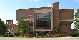
Waynesville is a city in and the county seat of Pulaski County, Missouri, United States. Its population was 5,406 at the 2020 census. Located in the Missouri Ozarks, it was once served by Route 66.

<span class="mw-page-title-main">Richland, Missouri</span> City in Missouri, United States

Richland is a city in Camden, Laclede, and Pulaski counties in the U.S. state of Missouri. The population was 1,863 at the 2010 census.

<span class="mw-page-title-main">Devils Elbow, Missouri</span> Unincorporated community in Missouri, U.S.

Devils Elbow is an unincorporated community in Pulaski County, Missouri, United States on historic U.S. Highway 66. It is situated on the Big Piney River and is named for a tight incised meander in the river known as a "devil of an elbow". The community is approximately five miles (8 km) east of St. Robert.

<span class="mw-page-title-main">Buckhorn, Pulaski County, Missouri</span> Community in the American state of Missouri

Buckhorn is a community in Pulaski County, Missouri, United States. It is on Route 17 just south of its junction with Interstate 44 It is also on historic U.S. Route 66. The community is within the Mark Twain National Forest and the northwest corner of Fort Leonard Wood is three miles to the east. Waynesville is six miles to the northeast along Route 44 and Laquey is two miles to the southwest off of Route 17.

<span class="mw-page-title-main">Gasconade River</span> River in central Missouri

The Gasconade River is about 280 miles (450 km) long and is located in central and south-central Missouri.

<span class="mw-page-title-main">Plato, Missouri</span> Village in Missouri, United States

Plato is an incorporated village in northwestern Texas County, Missouri, United States. It is located approximately 20 miles northwest of Houston and 10 miles south of Fort Leonard Wood on Route 32. The population was 82 at the 2020 census.

<span class="mw-page-title-main">Laquey, Missouri</span> Unincorporated community in the American state of Missouri

Laquey is an unincorporated community in Pulaski County, Missouri, United States. It has Zip Code: 65534 and Area Code: 573.

Roubidoux Creek is a tributary to the Gasconade River in the Ozarks of south central Missouri named after French-Canadian fur trader Joseph Robidoux. It is 57.4 miles (92.4 km) long. Due to its colder water temperatures, it is listed as a trout stream. Roubidoux Spring is a landmark that is nestled just south of downtown Waynesville. The creek cuts north through Fort Leonard Wood before crossing underneath Interstate 44 and into the city limits of Waynesville.

Fort Leonard Wood is a U.S. Army training installation located in the Missouri Ozarks. The main gate is located on the southern boundary of the city of St. Robert. The post was created in December 1940 and named in honor of General Leonard Wood in January 1941. Originally intended to train infantry troops, in 1941 it became an engineer training post with the creation of the Engineer Replacement Training Center. During World War II Italian and German POWs were interned at the fort. In 1984, as part of the Base Realignment and Closure process, most of the U.S. Army Engineer School's operations were consolidated at Fort Leonard Wood. Before that, officer training was conducted at Fort Belvoir, Virginia.

The Waynesville R-VI Reorganized School District is a school district in the Missouri Ozarks and the largest school district in Pulaski County. The school district current provides education services to the communities of Fort Leonard Wood, St. Robert, and almost all of Waynesville.

<span class="mw-page-title-main">David Day (Missouri politician)</span> American politician

David A. Day is a Republican former member of Missouri House of Representatives, representing Camden, Laclede, and Pulaski Counties. Elected to the House in 2004, in 2006 Day was appointed as Chairman of the House Veteran's Committee and served in that position until he left office at the end of 2012 due to term limits.

Cookville is an extinct town in southwestern Pulaski County, in the U.S. state of Missouri. The GNIS classifies it as a populated place. The town site is along Roubidoux Creek within the southern part of Fort Leonard Wood. The community of Greenview is located two miles to the west on Missouri Route 17 along the western boundary of the military reservation and adjacent to the Pulaski-Laclede county line.

Bidwell is an unincorporated community in northern Laclede County, in the Ozarks of southern Missouri. The community is located just west of Missouri Route 5 and 2.5 miles south of Decaturville in southern Camden County.

Brownfield is an unincorporated community in northeastern Laclede County, in the U.S. state of Missouri. The community is located just over one mile southeast of the Laclede-Pulaski county line and one mile east of Missouri Route K. It is within the Mark Twain National Forest and the Gasconade River lies just one mile to the east.

<span class="mw-page-title-main">Turley, Missouri</span> Extinct town in Texas County, Missouri

Turley is an extinct town in Texas County, in the U.S. state of Missouri. The GNIS classifies it as a populated place. The community is located on Roubidoux Creek, approximately two miles downstream (northwest) of Roubidoux. The community of Plato is about 4.5 miles to the northwest.

References

  1. 1 2 3 U.S. Geological Survey Geographic Names Information System: Saint Annie, Missouri
  2. Missouri Atlas & Gazetteer, DeLorme, 1st ed., 1998, p. 54 ISBN   0899332242
  3. Pictures - Stories – History of Pulaski County Rural Schools (2001 ed.). Pulaski County Historical Society. 1990. p. 165.
  4. History of Laclede, Camden, Dallas, Webster, Wright, Texas, Pulaski, Phelps and Dent counties, Missouri (1974 ed.). Chicago: Goodspeed Publishing Company. 1889. p. 139.
  5. Wilbur, Richard (1997). Pulaski County's Historic Place Names. Salem, Missouri: Conkle & de Roques. p. 10.
  6. "Cookville". The Pulaski County Democrat. October 7, 1910. p. 8. Retrieved August 16, 2022.
  7. Green, J. H. (January 13, 1905). "Reminiscences of Thirty-Four Years Ago". The Pulaski County Democrat. p. 1. Retrieved August 16, 2022.
  8. 1 2 3 Smith, Steven (2003). Made in the Timber: A Settlement History of the Fort Leonard Wood Region. Maneuver Support Center, Fort Leonard Wood. p. 110.
  9. Pulaski County’s Historic Place Names, Wilber, 1997, p. 10
  10. "St. Annie Church". Minutes of the Twenty-Second Annual Session of the Pulaski County Association of Baptist Churches Held with Idumea Baptist Church, August 25, 26, & 27, 1892; New Era Print, Rolla, Missouri: 10. 1892.
  11. Annual Minutes of the Pulaski County Association of Baptist Churches 1892-1896
  12. Minutes of the 25th Annual Session of the Pulaski County Association of Baptist Churches. Printed by Democrat Steam Printery, Waynesville, Missouri, Page 3
  13. (Minutes of the 25th Annual Session of the Pulaski County Association of Baptist Churches. Printed by Democrat Steam Printery, Waynesville, Missouri, Page 10
  14. Minutes of the Annual Session of the Pulaski County Association of Baptist Churches, 1911
  15. Forty ‘Leven Stories, York, 1975, p. 115
  16. National Archives Records Administration, U.S., Appointments of U. S. Postmasters, 1832-1971 Missouri: St. Francois - Wright, p. 379
  17. Post Office Department topographer’s office form, May 27, 1895
  18. National Archives Records Administration, U.S., Appointments of U. S. Postmasters, 1832-1971: St. Francis - Wright, p. 387
  19. Willets, Oma (1970). Where There Is No Vision the People Perish. Jefferson City, Missouri: Missouri Baptist Press. p. 7.