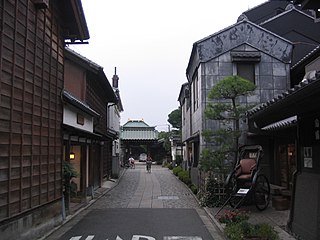
Kawagoe is a city in Saitama Prefecture, Japan. As of 1 February 2021, the city had an estimated population of 353,214 in 162,210 households and a population density of 3200 persons per km2. The total area of the city is 109.13 square kilometres (42.14 sq mi). The city is known locally as "Little Edo" after the old name for Tokyo, due to its many historic buildings.

Hanyū is a city located in Saitama Prefecture, Japan. As of 1 January 2021, the city had an estimated population of 54,304 in 23,487 households and a population density of 930 persons per km2. The total area of the city is 58.64 square kilometres (22.64 sq mi).

Sōka is a city in Saitama Prefecture, Japan. As of 1 February 2021, the city had an estimated population of 249,645 in 118,129 households and a population density of 9100 persons per km². The total area of the city is 27.46 square kilometres (10.60 sq mi).

Koshigaya is a city located in Saitama Prefecture, Japan. As of 1 January 2021, the city had an estimated population of 345,353 in 158,022 households and a population density of 5700 persons per km2. The total area of the city is 60.24 square kilometres (23.26 sq mi). It is famous for producing daruma dolls.

Asaka is a city located in Saitama Prefecture, Japan. As of 1 January 2021, the city had an estimated population of 143,195 and a population density of 7800 persons per km2. The total area of the city is 18.34 square kilometres (7.08 sq mi).

Niiza is a city in Saitama Prefecture, Japan. As of 1 January 2021, the city had an estimated population of 166,208 in 76,639 households and a population density of 7300 persons per km2. The total area of the city is 22.78 square kilometres (8.80 sq mi).

Kuki is a city located in Saitama Prefecture, Japan. As of 1 December 2020, the city had an estimated population of 152,569 in 67,339 households and a population density of 1900 persons per km2. The total area of the city is 82.41 square kilometres (31.82 sq mi).

Yashio is a city located in Saitama Prefecture, Japan. As of 1 January 2021, the city had an estimated population of 92,512 in 44,288 households and a population density of 5100 persons per km2. The total area of the city is 18.02 square kilometres (6.96 sq mi).

Sakado is a city in Saitama Prefecture, Japan. As of 1 January 2021, the city had an estimated population of 100,612 in 46,735 households and a population density of 2500 persons per km2. The total area of the city is 41.02 square kilometres (15.84 sq mi).
Tsurugashima is a city in Saitama Prefecture, Japan. On January 1, 2021, the city had an estimated population of 69,937 in 31,890 households and a population density of 4,000 per square kilometre (10,000/sq mi). The total area of the city is 17.65 square kilometres (6.81 sq mi).
Yoshikawa is a city located in Saitama Prefecture, Japan. As of 1 February 2021, the city had an estimated population of 73,262 in 31,031 households and a population density of 2300 persons per km2. The total area of the city is 31.66 square kilometres (12.22 sq mi).

Noda is a city located in the northwestern corner of Chiba Prefecture, Japan. As of 1 December 2020, the city had an estimated population of 154,114 in 69,191 households and a population density of 1500 persons per km2. The total area of the city is 103.54 square kilometres (39.98 sq mi). The city is famous for its production of soy sauce.

Moroyama is a town located in Saitama Prefecture, Japan. As of 1 January 2021, the town had an estimated population of 33,178 in 15,888 households and a population density of 970 persons per km2. The total area of the town is 34.07 square kilometres (13.15 sq mi).

Namegawa is a town located in Saitama Prefecture, Japan. As of 1 January 2021, the town had an estimated population of 19,594 in 8029 households and a population density of 660 persons per km2. The total area of the town is 29.68 square kilometres (11.46 sq mi).

Yorii is a town in Saitama Prefecture, Japan. As of 1 March 2021, the town had an estimated population of 32,851 in 14,689 households and a population density of 510 persons per km2. The total area of the town is 64.25 square kilometres (24.81 sq mi).

Miyashiro is a town located in Saitama Prefecture, Japan. As of 1 March 2021, the town had an estimated population of 33,823 in 15,234 households and a population density of 2100 persons per km2. The total area of the town is 15.95 square kilometres (6.16 sq mi).

Miyoshi is a town located in Saitama Prefecture, Japan. As of 28 February 2021, the town had an estimated population of 38,101 in 16,692 households and a population density of 2500 persons per km2. The total area of the town is 15.33 square kilometres (5.92 sq mi).

Ogose is a town located in Saitama Prefecture, Japan. As of 1 January 2021, the town had an estimated population of 11,352 in 5038 households and a population density of 280 persons per km². The total area of the town is 40.39 square kilometres (15.59 sq mi). The town is famous for its Prunus mume orchards.

Fujimino is a city located in Saitama Prefecture, Japan. As of 1 January 2021, the city had an estimated population of 114,566 in 53,053 households and a population density of 7800 persons per km². The total area of the city is 14.64 square kilometres (5.65 sq mi).

Saitama is the capital and largest city of Saitama Prefecture, Japan. Its area incorporates the former cities of Urawa, Ōmiya, Yono and Iwatsuki. It is a city designated by government ordinance. As of 1 February 2021, the city had an estimated population of 1,324,854, and a population density of 6,093 people per km². Its total area is 217.43 square kilometres (83.95 sq mi).


