
Hallamshire is the historical name for an area of South Yorkshire, England, approximating to the current City of Sheffield local government area.

High Bradfield is a rural village 6.5 miles (10 km) north-west of the centre of Sheffield in South Yorkshire, England and within the city's boundaries. The village lies just within the Peak District National Park, 1.3 miles (2 km) inside the park's north-eastern border, is at an altitude of 260 metres (850 feet) AOD, and has extensive views across Bradfield Dale towards Derwent Edge and the Dark Peak.

Low Bradfield is a village within the civil parish of Bradfield in South Yorkshire, England. It is situated within the boundary of the city of Sheffield in the upper part of the Loxley Valley, 6¼ miles west-northwest of the city centre and just inside the northeast boundary of the Peak District National Park. Low Bradfield and the surrounding area is noted for its attractive countryside which draws many visitors from the more urban parts of Sheffield. At weekends the village can become quite crowded, especially when there is a match on the village cricket pitch. Low Bradfield which stands in the shadow of Agden Reservoir has a sister village High Bradfield which is located at a higher altitude, ½ mile to the northeast. The two villages are joined by the steep Woodfall Lane.

Broomhill and Sharrow Vale — which includes the districts of Broomhill, Broomhall, Crookesmoor, Endcliffe, Sharrow Vale and Tapton Hill — is one of the 28 electoral wards in City of Sheffield, England. The ward was created following the 2015 local government boundary review out of parts of the old Broomhill, Central and Nether Edge wards. It is located in the western part of the city. The population of the Broomhill ward in 2011 was 16,966 people in 5,708 households, covering an area of 2.7 km2. Broomhill & Sharrow Vale is one of the wards that make up the Sheffield Central Parliamentary Constituency.
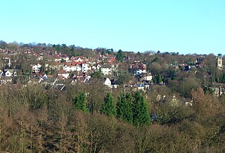
Crosspool is a suburb of the City of Sheffield, South Yorkshire, England, located 2.5 miles (4 km) west of the city centre. The suburb falls within the Crookes ward of the City of Sheffield. It is a middle class residential area in an elevated position above the Porter and Rivelin valleys and stands at around 660 feet (200 m) above sea level. Crosspool is situated on the A57 road and is the last suburb on that road before the city boundary and open countryside is reached. In 2011 Crosspool had a population of 6,703.

Fulwood ward—which includes the districts of Fulwood, Lodge Moor, and Ranmoor—is one of the 28 electoral wards in the City of Sheffield, England. It is located in the far western part of the city and covers an area of 23.2 km2. The population of this ward in 2011 was 18,233 people in 6,476 households. Fulwood ward is one of the five wards that make up the Sheffield Hallam Parliamentary constituency. As of June 2022, Andrew Sangar, Sue Alston, and Cliff Woodcraft, all Liberal Democrats, were councillors for the ward. The current Member of Parliament is Labour's Olivia Blake.
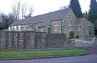
Whiteley Wood Hall was an English country house which was demolished in 1959. It stood off Common Lane in the Fulwood area of Sheffield, England. The hall’s stables and associated buildings are still standing and along with the surrounding grounds now serve as an outdoor activities centre for Girlguiding Sheffield. The stables are a Grade II listed building.

Strines Reservoir is a water storage reservoir situated at 53.4099°N 1.6557°W, 8 miles (13 km) west of the centre of Sheffield in South Yorkshire, England.

Fair House Farmhouse is a 17th-century building situated on Annet Lane in the village of Low Bradfield within the boundary of the City of Sheffield in South Yorkshire, England. The farmhouse is a Grade II* Listed Building while the stable and garage buildings immediately to the west of the main house are Grade II listed.

Hallfield House is a Grade II listed building situated in Bradfield Dale, 1.7 miles (2.74 km) west of the village of Low Bradfield, near Sheffield in England.

Fulwood Old Chapel is a Unitarian place of worship in the Fulwood district of western Sheffield, South Yorkshire. It is a member of the General Assembly of Unitarian and Free Christian Churches, the umbrella organisation for British Unitarians.

Underbank Chapel is a Unitarian place of worship in Stannington, a suburb of Sheffield, South Yorkshire. It is a member of the General Assembly of Unitarian and Free Christian Churches, the umbrella organisation for British Unitarians.

William John Hale was an architect based in Sheffield, England, who produced the city's most striking early 20th-century architecture. He practised between 1896 and 1929 and designed several schools and churches in Sheffield, using the Arts and Crafts and Art Nouveau styles as a basis.

Stumperlowe Hall is an English Manor House situated in the city of Sheffield, England. It is located on Stumperlowe Hall Road, in the suburb of Fulwood. The hall is a Grade II listed building.
Stumperlowe Cottage is a Grade II listed building situated on Stumperlowe Hall Road in the suburb of Fulwood in Sheffield, England. It was originally a cottage with an attached barn but has now been converted into one long residential building.

Brightholmlee is a small rural hamlet within the City of Sheffield in England. The hamlet falls within the Stannington Ward of the City. It is 6.2 miles (10 km) north-west of the city centre and 0.6 miles (1 km) west of Wharncliffe Side within Bradfield parish. Previously a farming community, it consist of four farmsteads, Manor Farm, Old Hall Farm, High Lea Farm and Lee Farm. It is now almost entirely residential with the last working farm being sold for development in 2013.

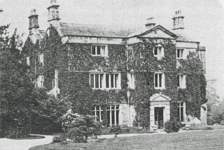
Sugworth Hall is an English country house on Sugworth Road in Bradfield Dale, near Sheffield, England. It is situated approximately 8 miles (13 km) west from Sheffield City Centre. The hall is a Grade II listed building which stands within the Peak District National Park at a height of 984 feet (300 m) above sea level.

Ughill is a small, rural hamlet within the City of Sheffield in Bradfield Parish in England. It is 5 mi west-northwest of the city centre. It stands in a lofty position at 918 ft above sea level, on a ridge between Bradfield Dale and the valley of the Ughill Brook. It has traditionally been a farming community, but there was some mining in the area in the late 19th and 20th century. Ughill Hall was the scene of an infamous murder in September 1986. The hamlet falls within the Stannington ward of the City.
Fulwood is a residential suburb and ward of the City of Sheffield in England, it lies 5.5 km west-southwest of the city centre. Formerly an ancient settlement and village on the Porter Brook, it became integrated into the city in the 1930s. It is bounded by the suburbs of Lodge Moor to the NW, Ranmoor to the east and Crosspool to the NE. The open countryside of the Peak District lies to the west and SW. The sub districts of Stumperlowe and Goole Green are part of the suburb. The population of the ward at the 2011 Census was 18,233. Fulwood is located in the Sheffield Hallam constituency which, as of the 2019 general election voted Labour.

Loxley United Reformed Church is a derelict Grade II* listed building located on Loxley Road in Loxley, a western suburb of the City of Sheffield, England. It is currently in a fire damaged state.
