Hillsborough Barracks

Last updated

Hillsborough Barracks
Sheffield
HillsboroughBarracks(JohnSTurner)Jun2004.jpg
Hillsborough Barracks
South Yorkshire UK location map.svg
Red pog.svg
Hillsborough Barracks
Location within South Yorkshire
Coordinates 53°24′05″N01°29′41″W / 53.40139°N 1.49472°W / 53.40139; -1.49472 Coordinates: 53°24′05″N01°29′41″W / 53.40139°N 1.49472°W / 53.40139; -1.49472
TypeBarracks
Site information
Owner Ministry of Defence
OperatorFlag of the British Army.svg  British Army
Site history
Built1848
Built for War Office
In use1848–1930

Hillsborough Barracks is a walled complex of buildings between Langsett Road and Penistone Road in the Hillsborough District of Sheffield, South Yorkshire, England.

Contents

Early history

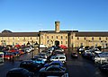
The complex, which covers an area of circa 22 acres (89,000 m2), dates from 1848, replacing an inadequate barracks at Hillfoot. [1]

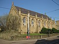
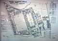
The barracks is divided into three terraces. The first (top) terrace faces on to what is now Langsett Road. This contained the Mess establishment, quarters for around 40 officers and a similar number of servants, and a chapel. This building has a length of about 354 feet (108 m) and a width and height of about 40 feet (12 m), is three storeys high and has a mixture of gothic and castellated styles. The other buildings of the barracks consisted of a large five-bedroomed house serving as the Garrison Commander’s Quarters outside the walls, a 58-patient two-storey hospital incorporating a barracks for RAMC personnel, a Dental Clinic and a facility for treating women, infantry soldiers' quarters, a clock tower building, with cavalry soldiers' quarters on the first floor and stabling for 260 horses on the ground floor (total accommodation for 918 NCO and other ranks). There was also a Fives Court, a Riding School, a school for 80 children and accommodation for the schoolmistress, married quarters flats for 50 families provided outside the walls, a Gun Shed housing six Field guns, the Barracks Store with living quarters for the Barracks Sergeant, a Guard Room incorporating a Police Room, Detention Cells, and an exercise yard, a Vehicle Shed (built in 1903) which could house 26 motor cars, a Veterinary Infirmary large enough to house 18 horses, a Granary, four cookhouses and various workshops. [1]

On the northern side of the Barracks runs the River Loxley. On the night of Friday 11 March 1864 the ill-fated Dale Dyke Dam further up the Loxley Valley at Bradfield burst causing the Great Sheffield Flood and the resulting flood waters breached a stone wall that was three feet thick. The water rose to the height of twelve feet outside the window of Sergeant Foulds' quarters and drowned two of his children. [2]

On 26 July 1932, an auction was held on the instructions of the War Department by Eadon & Lockwood at Sheffield. However, when bidding reached only £12,000, the auction was terminated and the Barracks withdrawn from sale. In October of that year, the complex was sold to Burdall’s Ltd, a manufacturing chemist noted for its gravy salt, and it became known as Burdall’s Buildings. [3]

Redevelopment

former cells now hotel rooms Garrison Hotel 2016 cell block rooms.jpg
former cells now hotel rooms

A major redevelopment of the site was embarked upon in the late 1980s. The result is the large retail and business complex seen today, in which all the surviving structures have been cleaned of the grime from Sheffield's industrial past. The focus of the complex is the Morrisons Supermarket covering the old Artillery Parade Ground, which has been roofed for the purpose and is fronted by the clock-towered stable block. The old Infantry Parade Ground is now a two-storey car park between the Stable Block and the old Officers' Mess (now the headquarters for Sheffield Insulations Ltd). The old football ground and rifle range are now a B&Q DIY Superstore. The Married Quarters which served as flats until the end of the 1970s were demolished and the area is now a McDonald's Drive-through Restaurant. The Garrison Commander’s House was demolished and its site is now covered with a garage and petrol station. The old guard room is now the Garrison Hotel and Jailhouse Bar. [4]

Related Research Articles

Hillsborough (ward) Electoral ward in the City of Sheffield, South Yorkshire, England

Hillsborough is an electoral ward which includes the districts of Malin Bridge, Owlerton, Wadsley and Wisewood. It is one of the 28 electoral wards in City of Sheffield, England. It is located in the northwestern part of the city and covers an area of 4.6 km2. The population of this ward in 2011 was 18,605 people in 8,012 households.

River Loxley River in South Yorkshire, England

The River Loxley is a river in the City of Sheffield, South Yorkshire, England. Its source is a series of streams which rise some 10 miles (16 km) to the north-west of Sheffield on Bradfield Moors, flowing through Bradfield Dale to converge at Low Bradfield. It flows easterly through Damflask Reservoir and is joined by Storrs Brook at Storrs, near Stannington, and the River Rivelin at Malin Bridge, before flowing into the River Don at Owlerton, in Hillsborough. The Loxley valley provided the initial course of the Great Sheffield Flood, which happened after the Dale Dyke Dam collapsed shortly before its completion in March 1864.

Malin Bridge is a suburb of the city of Sheffield, England. It is located at grid reference SK325893 and stands 2½ miles north-west of the city centre where the rivers Loxley and Rivelin meet. Malin Bridge is only a small district centred on the road bridge over the River Loxley which carries the B6076 road to Stannington ; it is surrounded by the suburbs of Hillsborough, Wisewood, Walkley and Stannington.

Dover Western Heights

The Western Heights of Dover are one of the most impressive fortifications in Britain. They comprise a series of forts, strong points and ditches, designed to protect the country from invasion. They were created in the 18th and 19th centuries to augment the existing defences and protect the key port of Dover from both seaward and landward attack; by the start of the 20th century Dover Western Heights was collectively reputed to be the 'strongest and most elaborate' fortification in the country. The Army finally withdrew from the Heights in 1956–61; they are now a local nature reserve.

Barracks Accommodation for military personnel or laborers

Barracks are usually a group of long buildings built to house military personnel or laborers. The English word comes via French from an old Spanish word "barraca" (hut), originally referring to temporary shelters or huts for various people and animals, but today barracks are usually permanent buildings for military accommodation. The word may apply to separate housing blocks or to complete complexes, and the plural form often refers to a single structure and may be singular in construction.

Owlerton is a suburb of the city of Sheffield, it lies 2.2 miles (3.5 km) northwest of the city centre near the confluence of the River Don and River Loxley. Owlerton was formerly a small rural village with its origins in the Early Middle Ages; it became part of Sheffield in the early 1900s as the city expanded. Owlerton stands just east of the adjacent suburb of Hillsborough and the division between the two districts is difficult to delineate. The suburb falls within the Hillsborough ward of the city. This is further complicated by the fact that certain buildings such as Hillsborough Stadium, Hillsborough Leisure Centre and Hillsborough College lie firmly within Owlerton. The name Owlerton is believed to come from the abundant growth of alder trees in the area

Loxley, South Yorkshire Village in South Yorkshire, England

Loxley is a village and a suburb of the city of Sheffield, England. It is a long linear community which stretches by the side of the River Loxley and along the B6077 for almost 2.5 miles (4 km). Loxley extends from its borders with the suburbs of Malin Bridge and Wisewood westward to the hamlet of Stacey Bank near Damflask Reservoir. The centre of the suburb is situated at the junction of Rodney Hill and Loxley Road where the old village green stands and this is located 3 miles (5 km) north west of Sheffield city centre. The suburb falls within the Stannington ward of the City of Sheffield.

Cavalry Barracks, Hounslow

Cavalry Barracks is a former British Army installation located north of Hounslow Heath in Hounslow, west London. Hounslow was one of 40 new barracks established around the country in the wake of the French Revolution, to guard against the dual threats of foreign invasion and domestic sedition. The barracks later became a busy depot for the London military district. The barracks have been described by Historic England as 'one of the most significant and complete barracks in the country'; as of June 2021 the site is scheduled to be developed as a sustainable living project by Hounslow Council.

Gun Club Hill Barracks

Gun Club Hill Barracks are barracks in King's Park, or in Jordan, Hong Kong formerly used by British Army garrisons during British colonial rule. The military began using the area shortly after 1860 when the British acquired Kowloon. The barracks are bounded by Austin Road, Jordan Path, Gascoigne Road and Chatham Road South.

Hillsborough is a suburb in north-west Sheffield, South Yorkshire, England. The centre of the district is popularly thought to be 'Hillsborough Corner' where Langsett Road, Middlewood Road, Holme Lane and Bradfield Road all meet. The Hillsborough ward population at the 2011 Census was 18,605.

Hillsborough Interchange

Hillsborough Interchange is a bus and tram interchange in Hillsborough, Sheffield. It serves a variety of operators including First South Yorkshire, Powell's Bus, Sheffield Supertram and Stagecoach Yorkshire, South Pennine Community Transport. It is staffed between 07:00 and 19:00 Monday to Saturday and has six bus stands and two tram platforms.

Fair House Farmhouse

Fair House Farmhouse is a 17th-century building situated on Annet Lane in the village of Low Bradfield within the boundary of the City of Sheffield in South Yorkshire, England. The farmhouse is a Grade II* Listed Building while the stable and garage buildings immediately to the west of the main house are Grade II listed..

Fort Sully was one of the main military posts located on the east bank of the Missouri river in central Dakota built for use in the Indian Wars. There were two forts named Sully—old Fort Sully, which was in existence and occupied from 1863 to 1866, and the later, or new Fort Sully, which was established in 1866 and was continuously occupied as a military fort until its abandonment in the fall of 1894.

Petrie Terrace Police Depot Historic building in Brisbane, Queensland

Petrie Terrace Police Depot is a heritage-listed former police barracks at 25-61 Petrie Terrace, Petrie Terrace, City of Brisbane, Queensland, Australia. It was built from 1850s to 1960s. It was added to the Queensland Heritage Register on 23 July 1999.

MoD Shoeburyness Military installation

MoD Shoeburyness is a military installation at Pig's Bay near Shoeburyness in Essex.

Forton Barracks

Forton Barracks was a military installation near Gosport in Hampshire, which served first as an Army barracks and then as a divisional headquarters for the Royal Marines. It subsequently served as a Royal Navy training establishment. Today, the site is occupied by St Vincent College.

Loxley United Reformed Church

Loxley United Reformed Church is a derelict Grade II* listed building located on Loxley Road in Loxley, a western suburb of the City of Sheffield, England. It is currently in a fire damaged state.

Cockatoo Island Prison Barracks Precinct

Prison Barracks Precinct is a heritage-listed prison precinct at Cockatoo Island, Sydney Harbour, New South Wales, Australia. It was added to the Australian Commonwealth Heritage List on 22 June 2004.

Royal Artillery Barracks, Woolwich Barracks in the Royal Borough of Greenwich in London, England

Royal Artillery Barracks, Woolwich, is a barracks of the British Army which forms part of Woolwich Garrison. The Royal Regiment of Artillery had its headquarters here from 1776 until 2007, when it was moved to Larkhill Garrison.

References

  1. 1 2 Bailey to Bailey - A Short History of Military Building in Sheffield by Stephen Johnson
  2. Harrison, Samuel (1864). A complete history of the great flood at Sheffield on March 11 & 12, 1864. S. Harrison. ISBN   0-904293-01-7. OCLC   2905832.
  3. Britain from above
  4. "History". Garrison Hotel, Sheffield. Retrieved 9 November 2017.