Gale Peak

Last updated

Gale Peak
Gale Peak.jpg
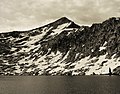
West aspect, above Chain Lakes
Highest point
Elevation 10,690 ft (3,258 m) [1]
Prominence 600 ft (183 m) [2]
Isolation 3.73 mi (6.00 km) [3]
Coordinates 37°34′05″N119°23′13″W / 37.5679873°N 119.3870782°W / 37.5679873; -119.3870782 [4]
Naming
Etymology George H. G. Gale
Geography
Relief map of California.png
Red triangle with thick white border.svg
Gale Peak
Location in California
Usa edcp relief location map.png
Red triangle with thick white border.svg
Gale Peak
Gale Peak (the United States)
Location Yosemite National Park
Madera County, California, U.S.
Parent range Sierra Nevada
Topo map USGS Sing Peak
Geology
Rock age Cretaceous
Mountain type Fault block
Rock type Granodiorite
Climbing
First ascent 1920
Easiest route class 2 [3]

Gale Peak is a 10,690-foot-elevation (3,260-meter) mountain summit located in Madera County, California, United States. It is situated in the Sierra Nevada mountain range, in the southeast corner of Yosemite National Park, on the common boundary which the park shares with the Ansel Adams Wilderness. The mountain rises 1.3 miles (2.1 km) south of Fernandez Pass, 4.5 miles (7.2 km) south of the Clark Range, and 2.2 miles (3.5 km) north-northwest of Madera Peak. Precipitation runoff from this landform drains west into tributaries of the South Fork Merced River, and east into tributaries of the San Joaquin River. Topographic relief is significant as the summit rises 1,400 feet (430 meters) above Upper Chain Lake in 0.38 miles (0.61 km). The peak can be climbed via the class 2 northwest ridge which separates Breeze Lake from the Chain Lakes. [1]

Contents

History

This geographical feature was named in 1894 by Lieutenant Nathaniel Fish McClure who prepared a map of Yosemite National Park for use by Army troops. [5] The toponym honors Captain George Henry Goodwin Gale, 4th Cavalry US Army, and the acting military superintendent of Yosemite Park in 1894. [6] The US Army had jurisdiction over Yosemite National Park from 1891 to 1914, and each summer 150 cavalrymen traveled from the Presidio of San Francisco to patrol the park. This geographical feature's toponym was officially adopted in 1932 by the U.S. Board on Geographic Names. [4]

The first ascent of the summit was made in 1920 by Lawrence Fley, Freeman Jones, and Thomas Jones. [1]

Climate

According to the Köppen climate classification system, Gale Peak is located in an alpine climate zone. [7] Most weather fronts originate in the Pacific Ocean and travel east toward the Sierra Nevada mountains. As fronts approach, they are forced upward by the peaks (orographic lift), causing them to drop their moisture in the form of rain or snowfall onto the range.

See also

References

  1. 1 2 3 Richard M. Leonard, Climber’s Guide to the High Sierra (1954)
  2. "Gale Peak, California". Peakbagger.com. Retrieved June 23, 2022.
  3. 1 2 "Gale Peak - 10,700' CA". listsofjohn.com. Retrieved June 23, 2022.
  4. 1 2 "Gale Peak". Geographic Names Information System . United States Geological Survey, United States Department of the Interior . Retrieved June 23, 2022.
  5. Erwin Gustav Gudde, William Bright, California Place Names: The Origin and Etymology of Current Geographical Names, 1998, University of California Press, ISBN   9780520213166, page 140.
  6. Francis P. Farquhar, Place Names of the High Sierra (1926)
  7. "Climate of the Sierra Nevada". Encyclopædia Britannica .