Galveston, Virginia

Last updated

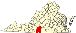
Galveston is an unincorporated community in Pittsylvania County, in the U.S. state of Virginia.

Pittsylvania County, Virginia County in the United States

Pittsylvania County is a county located in the Commonwealth of Virginia. As of the 2010 census, the population was 63,506. Its county seat is Chatham.

U.S. state constituent political entity of the United States

In the United States, a state is a constituent political entity, of which there are currently 50. Bound together in a political union, each state holds governmental jurisdiction over a separate and defined geographic territory and shares its sovereignty with the federal government. Due to this shared sovereignty, Americans are citizens both of the federal republic and of the state in which they reside. State citizenship and residency are flexible, and no government approval is required to move between states, except for persons restricted by certain types of court orders. Four states use the term commonwealth rather than state in their full official names.

Virginia State of the United States of America

Virginia, officially the Commonwealth of Virginia, is a state in the Southeastern and Mid-Atlantic regions of the United States located between the Atlantic Coast and the Appalachian Mountains. Virginia is nicknamed the "Old Dominion" due to its status as the first English colonial possession established in mainland North America and "Mother of Presidents" because eight U.S. presidents were born there, more than any other state. The geography and climate of the Commonwealth are shaped by the Blue Ridge Mountains and the Chesapeake Bay, which provide habitat for much of its flora and fauna. The capital of the Commonwealth is Richmond; Virginia Beach is the most populous city, and Fairfax County is the most populous political subdivision. The Commonwealth's estimated population as of 2018 is over 8.5 million.

Related Research Articles

Farmington Township, Clarion County, Pennsylvania Township in Pennsylvania, United States

Farmington Township is a township in Clarion County, Pennsylvania, United States. The population was 1,934 at the 2010 census.

Mount Airy, Pittsylvania County, Virginia human settlement in United States of America

Mount Airy is an unincorporated community in northeastern Pittsylvania County, Virginia, United States. Its altitude is 643 feet (196 m), and it is located at 36°56′35″N79°11′32″W, along State Route 40 between Gretna and Brookneal. It is included in the Danville, Virginia Metropolitan Statistical Area.

Arcadia was an unincorporated area in Galveston County, Texas, United States, which is now a neighborhood of the city of Santa Fe. It sits at an elevation of 30 feet (9 m).

East Canyon State Park state park in Morgan County, Utah, United States

East Canyon State Park is a state park of Utah, USA, featuring a 608-acre (246 ha) reservoir. The park is located northeast of Salt Lake City in Morgan County, Utah.

Pine Hill, New York is a hamlet in the town of Cheektowaga in Erie County, New York, United States.

Beverly Heights is an unincorporated community in Pittsylvania County, in the U.S. state of Virginia.

Brosville is an unincorporated community in Pittsylvania County, in the U.S. state of Virginia.

Callahans Hills is an unincorporated community in Pittsylvania County, in the U.S. state of Virginia.

Fox Hollow is an unincorporated community in Pittsylvania County, in the U.S. state of Virginia.

Green Pond is an unincorporated community in Pittsylvania County, in the U.S. state of Virginia.

Jones Mill is an unincorporated community in Pittsylvania County, in the U.S. state of Virginia.

Laniers Mill is an unincorporated community in Pittsylvania County, in the U.S. state of Virginia.

Pickaway is an unincorporated community in Pittsylvania County, in the U.S. state of Virginia.

Pleasant Grove is an unincorporated community in Henry County, Virginia, in the U.S. state of Virginia. Located at the crossroads of Stones Dairy, Hodges Farm, Preston, and Wingfield Orchard Roads. It is about 7 miles west of Martinsville, between Horse Pasture and Bassett, Virginia.

Smothers is an unincorporated community in Pittsylvania County, in the U.S. state of Virginia.

Soapstone is an unincorporated community in Pittsylvania County, in the U.S. state of Virginia.

Sutherlin is an unincorporated community in Pittsylvania County, in the U.S. state of Virginia.

Turkey Fork is an unincorporated community in Pittsylvania County, in the U.S. state of Virginia.

Vance is an unincorporated community in Pittsylvania County, in the U.S. state of Virginia.

Witt is an unincorporated community in Pittsylvania County, in the U.S. state of Virginia.

References

Coordinates: 36°55′12″N79°23′00″W / 36.92000°N 79.38333°W / 36.92000; -79.38333

Geographic coordinate system Coordinate system

A geographic coordinate system is a coordinate system that enables every location on Earth to be specified by a set of numbers, letters or symbols. The coordinates are often chosen such that one of the numbers represents a vertical position and two or three of the numbers represent a horizontal position; alternatively, a geographic position may be expressed in a combined three-dimensional Cartesian vector. A common choice of coordinates is latitude, longitude and elevation. To specify a location on a plane requires a map projection.