Related Research Articles

Pittsylvania County is a county located in the Commonwealth of Virginia. At the 2020 census, the population was 60,501. The county seat is Chatham.

Rocky Mount is a town in and the county seat of Franklin County, Virginia, United States. The town is part of the Roanoke metropolitan area, and had a population of 4,903 as of the 2020 census. It is located in the Roanoke Region of Virginia.

The Roanoke River runs 410 miles (660 km) long through southern Virginia and northeastern North Carolina in the United States. A major river of the southeastern United States, it drains a largely rural area of the coastal plain from the eastern edge of the Appalachian Mountains southeast across the Piedmont to Albemarle Sound. An important river throughout the history of the United States, it was the site of early settlement in the Virginia Colony and the Carolina Colony. An 81-mile (130 km) section of its lower course in Virginia between the Leesville Lake and Kerr Lake is known as the Staunton River, pronounced, as is the Shenandoah Valley city of that name. It is impounded along much of its middle course to form a chain of reservoirs.

Claude Augustus Swanson was an American lawyer and Democratic politician from Virginia. He served as U.S. Representative (1893–1906), Governor of Virginia (1906–1910), and U.S. Senator from Virginia (1910–1933), before becoming U.S. Secretary of the Navy under President Franklin D. Roosevelt from 1933 until his death. Swanson and fellow U.S. Senator Thomas Staples Martin led a Democratic political machine in Virginia for decades in the late 19th and early 20th century, which later became known as the Byrd Organization for Swanson's successor as U.S. Senator, Harry Flood Byrd.
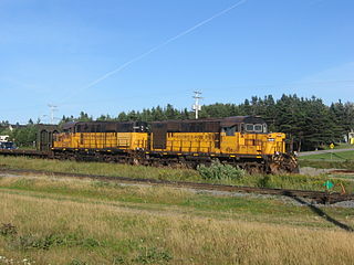
The Wabush Lake Railway is a short line railway operating in the province of Newfoundland and Labrador, Canada.
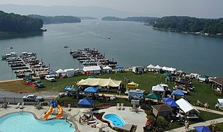
Smith Mountain Lake is a large reservoir in the Roanoke Region of Virginia, United States, located southeast of the City of Roanoke and southwest of Lynchburg. The lake was created in 1963 by the Smith Mountain Dam impounding the Roanoke River. The majority of the south shore of the lake lies in Franklin County while a small portion, including access to the dam, lies in Pittsylvania County. Bedford County makes up the northern half of the lake with the Roanoke River as the dividing line. The lake has become a popular recreation spot and has also experienced significant development in the last decade. It is the largest lake contained entirely within the Commonwealth of Virginia.
The Pigg River is a river in south-west Virginia in the United States. It is a tributary of the Roanoke River, which flows to the Atlantic Ocean via Albemarle Sound.

State Route 43 is a primary state highway in the U.S. state of Virginia. The state highway consists of two disjoint segments that have a total length of 61.20 miles (98.49 km). The southern portion of the state highway runs 39.79 miles (64.04 km) from U.S. Route 29 Business in Altavista north to the Blue Ridge Parkway at Peaks of Otter. The northern segment has a length of 21.41 miles (34.46 km) between the Blue Ridge Parkway near Buchanan and US 220 in Eagle Rock. The two sections of SR 43 are connected by 4.9 miles (7.9 km) of the Blue Ridge Parkway. The southern portion of the state highway connects Altavista with Bedford and Peaks of Otter. The northern section of SR 43 follows the James River through a narrow valley between Buchanan and Eagle Rock.

State Route 57 is a primary state highway in the U.S. state of Virginia. The state highway runs 88.70 miles (142.75 km) from SR 8 near Woolwine east to SR 360 near Halifax. SR 57 connects the independent city of Martinsville with Chatham and Halifax, the county seats of Pittsylvania and Halifax counties, respectively. The state highway also connects the city to Fairy Stone State Park.

The Katahdin Iron Works is a Maine state historic site located in the unorganized township of the same name. It is the site of an ironworks which operated from 1845 to 1890. In addition to the kilns of the ironworks, the community was served by a railroad and had a 100-room hotel. The site was listed on the National Register of Historic Places in 1969.

Leesville Lake is a reservoir in Virginia used for hydroelectric power generation in conjunction with Smith Mountain Lake as a pump storage project. It is located southeast of Roanoke, and southwest of Lynchburg.

The Ogden Mine Railroad was a mine railroad in the U.S. state of New Jersey from 1866 until 1941.

Archibald McIntyre, was an American merchant and politician.
The Roanoke Region is the area of the Commonwealth of Virginia surrounding the city of Roanoke. Its usage may refer to the metropolitan statistical area or the Roanoke Valley, but it sometimes includes areas in the Allegheny Mountains and New River Valley which includes Alleghany County, Montgomery County, Covington, Clifton Forge, Blacksburg, Christiansburg, and Radford. Bedford County and Floyd County are sometimes included as part of the region.
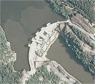
Smith Mountain Dam is a concrete arch dam located on the Roanoke River in Virginia, creating Smith Mountain Lake. The dam was built by Appalachian Power between 1960 and 1963 for the purposes of pumped-storage hydroelectricity. The dam created Smith Mountain Lake as its reservoir, where recreation and real estate have become popular.
The Quebec North Shore and Labrador Railway is a private Canadian regional railway that stretches 414 kilometres (257 mi) through the wilderness of northeastern Quebec and western Labrador. It connects Labrador City, Labrador, with the port of Sept-Îles, Quebec, on the north shore of the St. Lawrence River. QNS&L is owned by Iron Ore Company of Canada (IOC), and is a common carrier.
Noble Furnace is an unincorporated community in Wythe County, Virginia, United States. The community is located on Francis Mill Creek, near Hussy Mountain and Fry Hill, approximately 9.6 miles (15.4 km) south of Wytheville. Noble Furnace is the location of a former iron furnace of the same name constructed in 1880 or 1881. The cold blast furnace was steam powered and its stack was constructed of stone. The furnace was owned by the Norma Iron Company and utilized primarily limestone ore which was transported from nearby deposits to the furnace via tramway.
The original Maggoty Gap was a wind gap in the Blue Ridge Mountains in the counties of Roanoke, Virginia and Franklin, Virginia. Over time, as roads were improved and relocated, the identified location of the gap moved with them. It is now mapped at a spot in Roanoke County.
Smith Mountain Cooperative Wildlife Management Area is a 4,996-acre (20.22 km2) Wildlife Management Area (WMA) in Bedford and Pittsylvania counties, Virginia. Located on the shores of Smith Mountain Lake, the WMA is owned by Appalachian Power and cooperatively managed by the Virginia Department of Game and Inland Fisheries and the Virginia Outdoors Foundation through a conservation easement that permits public access.
The Duluth, Missabe and Northern Railway (DM&N) was a railroad company in the U.S. state of Minnesota. It was one of the earliest iron ore hauling railroads of the area, said to have built the largest iron ore docks in the world, and later was one of the constituent railroads in the merger that formed the Duluth, Missabe and Iron Range Railway.
References
- U.S. Geological Survey Geographic Names Information System: Pittsville, Virginia
- The History of Pittsylvania County, Virginia by Maud Carter Clement
- Hand-book of Virginia, Volumes 81-886 by Virginia Dept. of Agriculture, Randolph Harrison

36°58′55″N79°27′43″W / 36.98194°N 79.46194°W
| | This Pittsylvania County, Virginia state location article is a stub. You can help Wikipedia by expanding it. |