Yosemite National Park is located in the central Sierra Nevada of California. Three wilderness areas are adjacent to Yosemite: the Ansel Adams Wilderness to the southeast, the Hoover Wilderness to the northeast, and the Emigrant Wilderness to the north.
The 1,189sqmi (3,080km2) park is roughly the size of the U.S. state of Rhode Island and contains thousands of lakes and ponds, 1,600 miles (2,600km) of streams, 800 miles (1,300km) of hiking trails, and 350 miles (560km) of roads.[1] Two federally designated Wild and Scenic Rivers, the Merced and the Tuolumne, begin within Yosemite's borders and flow westward through the Sierra foothills, into the Central Valley of California. Annual park visitation exceeds 3.5million, with most visitor use concentrated in the seven-square-mile (18km2) area of Yosemite Valley.[1]
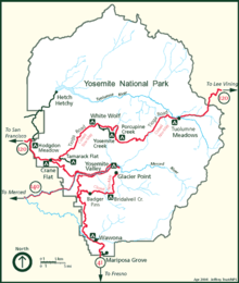
The geography of the Yosemite area can be visualized with the clickable map, below:
Painting of Yosemite by Heinrich C. Berann. Aerial view of the entire park from the west, looking east. Mouse over the picture and click on an area of interest.
Erosion acting upon different types of uplift-created joint and fracture systems is responsible for creating the valleys, canyons, domes, and other features we see today. These joints and fracture systems do not move, and are therefore not faults.[5] Spacing between joints is controlled by the amount of silica in the granite and granodiorite rocks; more silica tends to create a more resistant rock, resulting in larger spaces between joints and fractures.[6]
Pillars and columns, such as Washington Column and Lost Arrow, are created by cross joints. Erosion acting on master joints is responsible for creating valleys and later canyons.[6] The single most erosive force over the last few million years has been large alpine glaciers, which have turned the previously V-shaped river-cut valleys into U-shaped glacial-cut canyons (such as Yosemite Valley and Hetch Hetchy Valley). Exfoliation (caused by the tendency of crystals in plutonic rocks to expand at the surface) acting on granitic rock with widely spaced joints is responsible for creating domes such as Half Dome and North Dome and inset arches like Royal Arches.[7]
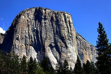
Yosemite Valley represents only one percent of the park area, but this is where most visitors arrive and stay. The Tunnel View is the first view of the Valley for many visitors and is extensively photographed. El Capitan, a prominent granite cliff that looms over Yosemite Valley, is one of the most popular rock climbing destinations in the world because of its diverse range of climbing routes in addition to its year-round accessibility. Granite domes such as Sentinel Dome and Half Dome rise 3,000 and 4,800 feet (910 and 1,460m), respectively, above the valley floor.
The high country of Yosemite contains beautiful areas such as Tuolumne Meadows, Dana Meadows, the Clark Range, the Cathedral Range, and the Kuna Crest. The Sierra crest and the Pacific Crest Trail run through Yosemite, with peaks of red metamorphic rock, such as Mount Dana and Mount Gibbs, and granite peaks, such as Mount Conness. Mount Lyell is the highest point in the park, standing at 13,120 feet (4,000m). The Lyell Glacier is the largest glacier in Yosemite National Park and is one of the few remaining in the Sierra Nevada today.
The park has three groves of ancient giant sequoia (Sequoiadendron giganteum) trees; the Mariposa Grove (200 trees), the Tuolumne Grove (25 trees), and the Merced Grove (20 trees).[8] This species grows larger in volume than any other and is one of the tallest and longest-lived.[9]
Water and ice
Tuolumne and Merced River systems originate along the crest of the Sierra Nevada in the park and have carved river canyons 3,000 to 4,000 feet (910 to 1,220m) deep. The Tuolumne River drains the entire northern portion of the park, an area of approximately 680 square miles (1,800km2). The Merced River begins in the park's southern peaks, primarily the Cathedral and Clark Ranges, and drains an area of approximately 511 square miles (1,320km2).[10]
Hydrologic processes, including glaciation, flooding, and fluvial geomorphic response, have been fundamental in creating landforms in the park.[10] The park also contains approximately 3,200 lakes (greater than 100 m2), two reservoirs, and 1,700 miles (2,700km) of streams, all of which help form these two large watersheds.[11]Wetlands in Yosemite occur in valley bottoms throughout the park, and are often hydrologically linked to nearby lakes and rivers through seasonal flooding and groundwater movement. Meadow habitats, distributed at elevations from 3,000 to 11,000 feet (910 to 3,350m) in the park, are generally wetlands, as are the riparian habitats found on the banks of Yosemite's numerous streams and rivers.[12]
Bridalveil Fall flows from a U-shaped hanging valley that was created by a tributary glacier.
Yosemite is famous for its high concentration of waterfalls in a small area. Numerous sheer drops, glacial steps and hanging valleys in the park provide many places for waterfalls to exist, especially during April, May, and June (the snowmelt season). Located in Yosemite Valley, the Yosemite Falls is the highest in North America at 2,425-foot (739m). Also in Yosemite Valley is the much lower volume Ribbon Falls, which has the highest single vertical drop, 1,612 feet (491m).[9] Perhaps the most prominent of the Yosemite Valley waterfalls is Bridalveil Fall, which is the waterfall seen from the Tunnel View viewpoint at the east end of the Wawona Tunnel. Wapama Falls in Hetch Hetchy Valley is another notable waterfall. Hundreds of ephemeral waterfalls also exist in the park.
All glaciers in the park are relatively small glaciers that occupy areas that are in almost permanent shade, such as north- and northeast-facing cirques. Lyell Glacier is the largest glacier in Yosemite (the Palisades Glaciers are the largest in the Sierra Nevada) and covers 160 acres (65ha).[13] None of the Yosemite glaciers are a remnant of the much, much larger Ice Age alpine glaciers responsible for sculpting the Yosemite landscape. Instead, they were formed during one of the neoglacial episodes that have occurred since the thawing of the Ice Age (such as the Little Ice Age).[8]Climate change has reduced the number and size of glaciers around the world. Many Yosemite glaciers, including Merced Glacier, which was discovered by John Muir in 1871 and bolstered his glacial origins theory of the Yosemite area, have disappeared and most of the others have lost up to 75% of their surface area.[13]
Yosemite has a Mediterranean climate (Köppen climate classificationCsa), meaning most precipitation falls during the mild winter, and the other seasons are nearly dry (less than 3% of precipitation falls during the long, hot summers).[14] Because of orographic lift, precipitation increases with elevation up to 8,000 feet (2,400m) where it slowly decreases to the crest. Precipitation amounts vary from 36 inches (910mm) at 4,000 feet (1,200m) elevation to 50 inches (1,300mm) at 8,600 feet (2,600m). Snow does not typically persist on the ground until November in the high country. It accumulates all winter and into March or early April.[15]
Mean daily temperatures range from 25°F (−4°C) to 53°F (12°C) at Tuolumne Meadows at 8,600 feet (2,600m). At the Wawona Entrance (elevation 5,130 feet or 1,560 metres), mean daily temperature ranges from 36 to 67°F (2 to 19°C). At the lower elevations below 5,000 feet (1,500m), temperatures are hotter; the mean daily high temperature at Yosemite Valley (elevation 3,966 feet or 1,209 metres) varies from 46 to 90°F (8 to 32°C). At elevations above 8,000 feet (2,400m), the hot, dry summer temperatures are moderated by frequent summer thunderstorms, along with snow that can persist into July. The combination of dry vegetation, low relative humidity, and thunderstorms results in frequent lightning-caused fires as well.[15]
At the park headquarters, with an elevation of 3,966 feet (1,209m), January averages 38.2°F (3.4°C), while July averages 73.0°F (22.8°C), though in summer the nights are much cooler than the hot days.[16] There are an average of 39.5 days with highs of 90°F (32°C) or higher and an average of 97.9 nights with freezing temperatures.[16] Freezing temperatures have been recorded in every month of the year. The record high temperature was 115°F (46°C) on July 20, 1915, while the record low temperature was −6°F (−21°C) on January 2, 1924, and on January 21, 1937.[16][17] Average annual precipitation is nearly 37 inches (940mm), falling on 65 days. The wettest year was 1983 with 68.94 inches (1,751mm) and the driest year was 1976 with 14.84 inches (377mm).[17] The most precipitation in one month was 29.61 inches (752mm) in December 1955 and the most in one day was 6.92 inches (176mm) on December 23, 1955.[17] Average annual snowfall is 65.6 inches (1.67m). The snowiest year was 1967 with 154.9 inches (3.93m). The most snow in one month was 140.8 inches (3.58m) in January 1993.[17]
Climate data for Yosemite Park Headquarters, elev. 3,966 feet (1,209m)
1 2 "Water Overview". National Park Service: Yosemite National Park. December 22, 2004. Archived from the original on January 7, 2007. Retrieved January 27, 2007.
↑ "Hydrology and Watersheds". National Park Service: Yosemite National Park. December 22, 2004. Archived from the original on July 28, 2010. Retrieved January 27, 2007.
↑ "Wetland Vegetation". National Park Service: Yosemite National Park. December 22, 2004. Archived from the original on April 19, 2010. Retrieved January 27, 2007.
1 2 "Climate". National Park Service: Yosemite National Park. December 22, 2004. Archived from the original on January 1, 2007. Retrieved January 27, 2007.
Yosemite National Park is a national park in California. It is bordered on the southeast by Sierra National Forest and on the northwest by Stanislaus National Forest. The park is managed by the National Park Service and covers 759,620 acres in four counties – centered in Tuolumne and Mariposa, extending north and east to Mono and south to Madera. Designated a World Heritage Site in 1984, Yosemite is internationally recognized for its granite cliffs, waterfalls, clear streams, giant sequoia groves, lakes, mountains, meadows, glaciers, and biological diversity. Almost 95 percent of the park is designated wilderness. Yosemite is one of the largest and least fragmented habitat blocks in the Sierra Nevada.
Yosemite Valley is a glacial valley in Yosemite National Park in the western Sierra Nevada mountains of Central California, United States. The valley is about 7.5 mi (12.1 km) long and 3,000–3,500 ft (910–1,070 m) deep, surrounded by high granite summits such as Half Dome and El Capitan, and densely forested with pines. The valley is drained by the Merced River, and a multitude of streams and waterfalls flow into it, including Tenaya, Illilouette, Yosemite and Bridalveil Creeks. Yosemite Falls is the highest waterfall in North America and is a big attraction, especially in the spring, when the water flow is at its peak. The valley is renowned for its natural environment and is regarded as the centerpiece of Yosemite National Park.
The Sierra Nevada is a mountain range in the Western United States, between the Central Valley of California and the Great Basin. The vast majority of the range lies in the state of California, although the Carson Range spur lies primarily in Nevada. The Sierra Nevada is part of the American Cordillera, an almost continuous chain of mountain ranges that forms the western "backbone" of the Americas.
Yosemite Valley is a census-designated place (CDP) in Mariposa County, California, United States. It consists of the developed area of Yosemite Village and the other areas of the Yosemite Valley in Yosemite National Park. The population was 337 at the 2020 census.
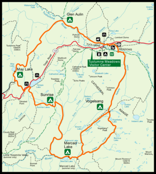
Tuolumne Meadows is a gentle, dome-studded, sub-alpine meadow area along the Tuolumne River in the eastern section of Yosemite National Park in the United States. Its approximate location is 37°52.5′N119°21′W. Its approximate elevation is 8,619 feet (2,627 m). The term Tuolumne Meadows is also often used to describe a large portion of the Yosemite high country around the meadows, especially in context of rock climbing.
The exposed geology of the Yosemite area includes primarily granitic rocks with some older metamorphic rock. The first rocks were laid down in Precambrian times, when the area around Yosemite National Park was on the edge of a very young North American continent. The sediment that formed the area first settled in the waters of a shallow sea, and compressive forces from a subduction zone in the mid-Paleozoic fused the seabed rocks and sediments, appending them to the continent. Heat generated from the subduction created island arcs of volcanoes that were also thrust into the area of the park. In time, the igneous and sedimentary rocks of the area were later heavily metamorphosed.
The Mist Trail is one of the most popular short hikes in Yosemite National Park, California, USA. The steep hike follows the Merced River, starting at Happy Isles in Yosemite Valley, past Vernal Fall and Emerald Pool, to Nevada Fall.
The Merced River, in the central part of the U.S. state of California, is a 145-mile (233 km)-long tributary of the San Joaquin River flowing from the Sierra Nevada into the San Joaquin Valley. It is most well known for its swift and steep course through the southern part of Yosemite National Park, where it is the primary watercourse flowing through Yosemite Valley. The river's character changes dramatically once it reaches the plains of the agricultural San Joaquin Valley, where it becomes a slow-moving meandering stream.
The ecology of the Sierra Nevada, located in the U.S. states of California and Nevada, is diverse and complex. The combination of climate, topography, moisture, and soils influences the distribution of ecological communities across an elevation gradient from 500 to 14,500 feet. Biotic zones range from scrub and chaparral communities at lower elevations, to subalpine forests and alpine meadows at the higher elevations. Particular ecoregions that follow elevation contours are often described as a series of belts that follow the length of the Sierra Nevada. There are many hiking trails, paved and unpaved roads, and vast public lands in the Sierra Nevada for exploring the many different biomes and ecosystems.
Tenaya Lake is an alpine lake in Yosemite National Park, located between Yosemite Valley and Tuolumne Meadows. The surface of Tenaya Lake has an elevation of 8,150 feet (2,484 m). The lake basin was formed by glacial action, which left a backdrop of light granite rocks, whose beauty was known to the Native Americans. Today, Tenaya Lake is easily accessible by State Route 120 and is a popular lake for water activities.
The Emigrant Wilderness of Stanislaus National Forest is a wilderness area in the Sierra Nevada. It is bordered by Yosemite National Park on the south, the Toiyabe National Forest and the Hoover Wilderness on the east, and State Route 108 over Sonora Pass on the north. It is an elongated area that extends northeast about 25 miles (40 km) in length and up to 15 miles (24 km) in width. Watersheds drain to the Stanislaus and Tuolumne Rivers. The Emigrant Wilderness area, which is a glaciated landscape, is entirely within Tuolumne County, California and is approximately 140 miles (230 km) east of San Francisco, California and 50 miles (80 km) south of Lake Tahoe.
Mount Lyell is the highest point in Yosemite National Park, at 13,114 feet (3,997 m). It is located at the southeast end of the Cathedral Range, 1+1⁄4 miles northwest of Rodgers Peak. The peak as well as nearby Lyell Canyon is named after Charles Lyell, a well-known 19th century geologist. The peak had one of the last remaining glaciers in Yosemite, Lyell Glacier. The Lyell Glacier is currently considered to be a permanent ice field, not a living glacier. Mount Lyell divides the Tuolumne River watershed to the north, the Merced to the west, and the Rush Creek drainage in the Mono Lake Basin to the southeast.
Little Yosemite Valley is a smaller glacial valley upstream in the Merced River drainage from the Yosemite Valley in Yosemite National Park. The Merced River meanders through the 3.5 mi (5.6 km) long flat valley, draining out over Nevada Fall and Vernal Fall before emptying into the main Yosemite Valley. It can be reached by a day hike from the main valley, and is the most popular area in the Yosemite Wilderness. The Valley provides access to nearby destinations such as the back side of Half Dome, Clouds Rest and the High Sierra Camp at Merced Lake.
The High Sierra Camps are nine rustic lodging facilities located in two national parks and a national monument in California's Sierra Nevada mountain range. Open most years from June or July to September, they are staffed camps with tent cabins and food service facilities. The backcountry camps receive their supplies by pack mules.
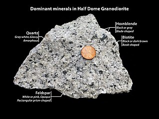
Half Dome Granodiorite is granodiorite found in a region on and near Half Dome, in Yosemite National Park, California, United States. The granodiorite forms part of the Tuolumne Intrusive Suite, one of the four major intrusive suites within the Sierra Nevada.
Exfoliating granite is a granite undergoing exfoliation, or onion skin weathering (desquamation). The external delaminated layers of granite are gradually produced by the cyclic variations of temperature at the surface of the rock in a process also called spalling. Frost and ice expansion in the joints during the winter accelerate the alteration process while the most unstable loosen external layers are removed by gravity assisted by runoff water.
Kuna Crest Granodiorite, is found, in Yosemite National Park, United States. The granodiorite forms part of the Tuolumne Intrusive Suite, one of the four major intrusive suites within the Sierra Nevada. Of the Tuolumne Intrusive Suite, it is the oldest and darkest rock.
The Tuolumne Intrusive Suite is the youngest and most extensive of the intrusive suites of Yosemite National Park, and also comprises about 1/3 of the park's area. The Suite includes Half Dome Granodiorite, Cathedral Peak Granite, and Kuna Crest Granodiorite.
Hiking, rock climbing, and mountain climbing around Tuolumne Meadows in Yosemite National Park has many options.
This page is based on this Wikipedia article Text is available under the CC BY-SA 4.0 license; additional terms may apply. Images, videos and audio are available under their respective licenses.