Geologic map of Georgia (U.S. state)

Last updated

The geologic map of Georgia (a state within the United States) is a special-purpose map made to show geological features. Rock units or geologic strata are shown by colors or symbols to indicate where they are exposed at the surface. Structural features such as faults and shear zones are also shown. Since the first national geological map, in 1809, there have been numerous maps which included the geology of Georgia. The first Georgia specific geologic map was created in 1825. The most recent state-produced geologic map of Georgia, by the Georgia Department of Natural Resources is 1:500,000 scale, and was created in 1976 by the department's Georgia Geological Survey. [1] It was generated from a base map produced by the United States Geological Survey. The state geologist and Director of the Geological Survey of Georgia was Sam M. Pickering, Jr. [2] Since 1976, several geological maps of Georgia, featuring the state's five distinct geologic regions, have been produced by the federal government.

Contents

History of geologic mapping in Georgia

Previous statewide geologic maps of Georgia

The first statewide geologic map of Georgia was published in 1825. It was a 1:1,000,000 scale map of Georgia and Alabama published by Henry Schenck Tanner. [3] In 1849 W.T. Williams published the geological features for the state on a 1:120,000 scale map within George White's (1849) Statistics of the State of Georgia report. [4] Then in 1871, Dr. Matthew Fleming Stephenson published a 1:1,200,000 scale map of the Geology and mineralogy of Georgia through the Globe Publishing Company of Atlanta. [5] This map was part of a report with the same name. [3] Another statewide map of the geology of Georgia was published in 1876 by G. Little in the Handbook of the State of Georgia by T.P. Janes. [6] In 1885 Georgia Commissioner of Agriculture J.T. Henderson produced a 1:2,500,000 scale map of the geology of Georgia. [7] In 1895 R. T. Nesbitt produced a small-scale geological map of Georgia that was included in a statistical review of the state. [8] The review was described as a Chamber of commerce styled work, that presented the economic mineral resources and geology of the state in a promotional and exaggerated manner. This was the last statewide geological map published in the 19th Century.

Within the 20th Century there were three statewide geological maps produced prior to the 1976 map. The first was a 1-inch to 15 mile map produced by S.W. McCallie in 1908. [9] In 1939, George Willis Stose et al. produced a 1:500,000 scale map that was published by the Georgia Geologic Survey and the United States Geological Survey. [10] This map was reprinted in 1960 by the U.S. Geological Survey. The third map was published in 1968 by the Geological Survey of Georgia. This map was produced by J.W. Smith and M.S. Green, a 1:2,500,000 scale map. [3]

Geologic maps that contained the geology of Georgia

North American geological map North america terrain 2003 map.jpg
North American geological map

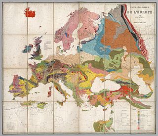
From the beginning of the United States, Georgia geology has been included in maps produced for the entire country. The first geological map of the U.S. was produced in 1809 by William Maclure. [11] [12] In 1807, Maclure undertook the self-imposed task of making a geological survey of the United States. He traversed and mapped nearly every state in the Union. During the rigorous two-year period of his survey, he crossed and recrossed the Allegheny Mountains some 50 times. [13] [14] The results of his unaided endeavor were submitted to the American Philosophical Society in a memoir entitled Observations on the Geology of the United States explanatory of a Geological Map, together with the nation's first geological map, which were published in the Society's journal Transactions, [15] This precedes William Smith's geological map of England by six years, although Smith's map was constructed using a different classification of rocks. Several reports used Maclure's geological map to accompany their description of the geology of the U.S. (Beaujour, 1814 [16] and Marcou, 1858). [17] In 1816, within an elementary treatise of mineralogy and geology, Parker Cleaveland produced a geological map of the U.S. [18] In 1843, Charles Moxon produced a small-scale geologic map of the U.S., where Ami Boué produced a geological structure map of the globe. [19] In 1853, Marcou produced a geological map of the U.S. and the British provinces of North America. [20]

Maclure's Geological Map of the United States as published in 1817 Maclure Geological Map Transactions 1817.jpg
Maclure's Geological Map of the United States as published in 1817

In 1856, Henry Darwin Rogers created a similar map of the geology of the U.S. and British North America. [21] There was a short description of the geologic map of the U.S. by Charles Henry Hitchcock in 1872, which had small-scale geological maps included. [22] Hitchcock and William P. Blake published a general geologic map of the U.S. in R.W. Raymond's Statistics of mines and mining. [23] In 1874, they published a geological map of the U.S. and territories in the U.S. Census 9th Statistical Atlas. [24] Hitchcock and Blake published a summary of this map in the Geological Magazine in 1873. [25] Gray's geological map of the U.S. was published in the National Atlas special edition at a scale of about 1 inch to 300 miles in 1876 and reprinted in 1886 by the American Institute of Mining Engineers. [26] A geological map of the U.S. east of the Rocky Mountains was produced at the scale of 1 inch to 105.5 miles by Frank H. Bradley. [27] In the 1880s several geological maps of the U.S. were produced. William John McGee offered a detailed description for the U.S. Geological Survey in 1884. [28] In 1887, Hitchcock produced a geological map of the U.S. and parts of Canada that was at the scale of 1 inch to 200 miles, with a review of the various maps of the U.S. that accompanied the geological map of the U.S. [29] In 1895, McGee and J.B. Tolbert produced a 1:15,000,000 scale map of the geology of the U.S. [30]

There have been a host of geological maps of the U.S. produced in the 20th century. Bailey Willis produced a geological map of the U.S. in 1906. [31] George W. Stose produced a 1:2,500,000 scale map in 1932, [32] [33] and a 1:500,000 scale map together with R.W. Smith in 1939. [34] A.K. Lobeck produced a Geologic map of the United States (with text on the reverse side) in 1941 [35] Those are just a few that have been produced. The most recent map being produced is the National Map that is a cooperative project. [36]

The 1976 map

The current geologic map of Georgia was produced in 1976. It was put together mainly in two parts from two teams representing the northern and southern portion of the state. [1] [37]

The map of Georgia is actually a compilation of numerous geological studies and mapping projects that occurred throughout the state and over an extended time period. [1] The major studies that are cited for contribution to the state geologic map fall under three main categories: New mapping by the Georgia Geological Survey, new mapping by the Georgia Geological Survey combined with revised published maps, and published maps with compilation revision only. The majority of the rock units shown on the 1976 map were mapped in 1973 by reconnaissance methods. For some areas, previous authors provided more detailed work than the reconnaissance conducted by the geological survey staff. In those areas, the original author's work was used in compiling the state map.

Recent geologic mapping in the state of Georgia

Map produced by the U.S. Department of the Interior Geologic Map of Georgia.png
Map produced by the U.S. Department of the Interior

More recently, geologic mapping has been undertaken by the Georgia Geological Survey through the STATEMAP project. [38] This project was funded from the National Geologic Mapping Act of 1992. [39] This federal act was for the purpose of producing geologic maps that for 2 decades had been drastically curtailed. It was recognized that "geologic maps are the primary data base for virtually all applied and basic earth-science applications". [39] This act provided 50% of the funds needed, whereas each state that wanted to participate supplied the other 50% of the funding to complete these various mapping projects. Ultimately this project was to be a part of the National Map and the subsequent databases generated by the various state and national mapping projects.

The geology of Georgia

The geology of Georgia consists of five distinct geologic regions, beginning in the northwest corner of the state and moving through the state to the southeast: the Ridge and Valley region also known as the Appalachian Plateau, the Blue Ridge, the Piedmont, the Fall Line and the Coastal Plain. [40]

Appalachian plateau

The Appalachian Plateau geologic region only passes through the extreme northwest corner of Georgia. During the middle Ordovician Period (about 440 - 480 million years ago), the tectonic plate carrying this area collided with another plate, leading to the creation of a new subduction zone and the beginning of the Appalachians [41] As a result of this and later orogenies, alternating beds of hard and soft Paleozoic sedimentary rocks were folded, looking much like the wrinkles one would find in a kicked floor rug. [42] In Georgia, the Ridge and Valley includes limestone, sandstone, shale and other sedimentary rocks, which have yielded construction-grade limestone, barite, ochre and small amounts of coal. [40] The extent of the Ridge and Valley is bound by the Carters Dam Fault in the east and the Emerson Fault in the south. [43]

Geologic regions in Georgia Ga geologic regions.gif
Geologic regions in Georgia

Blue ridge

The Blue Ridge geologic region forms the North Georgia mountains. In this region, the highest points in Georgia are found, including Brasstown Bald. The Blue Ridge consists of metamorphic rocks, either metamorphosed equivalents of sedimentary rocks or igneous rocks, and the region includes the metavolcanic rocks of the Georgia Gold Belt. [40] The region also includes igneous intrusions of granite and diabase. [43] From the discovery of gold in the Georgia Gold Belt in 1828, enough gold was mined in the area to cause a branch mint of the United States Mint to be located in Dahlonega, Georgia. Marble and talc are other resources produced in the Blue Ridge in Georgia. [40]

Piedmont

The Piedmont geologic region is composed of igneous and metamorphic rocks resulting from ancient (300 to 600 million year old) sediments that were subjected to high temperatures and pressures and re-exposed about 250 to 300 million years ago. [44] Rocks typical of the region include schist, amphibolite, gneiss, migmatite, and granite. [40] This region is more hilly than mountainous and is marked by lower elevations than the Blue Ridge. Nevertheless, the Piedmont is home to prominent features like Stone Mountain [40] and the Brevard Fault line which runs parallel to the Chattahoochee River and bisects cities like Suwanee, Atlanta, and Buford.

Fall Line

The Fall Line is the geomorphologic break [45] between the upland region of relatively hard crystalline basement rock and the coastal plain of softer sedimentary rock. [46] The Fall Line is most prominent when crossed by a river. It is at this point that cities developed, because riverboats could not typically travel any farther inland without portaging. In some locations, the rapid change in elevation of the water, and the resulting energy release, made the Fall Line a good location for water mills, grist mills, and sawmills. Because of the need for a river port leading to the ocean, and a ready supply of water power, settlements developed where rivers crossed the Fall Line. In Georgia, the Fall Line extends from Augusta, through Macon, and on to Columbus.

The Coastal Plain of the U.S. Coastal Plain.jpg
The Coastal Plain of the U.S.

Coastal plain

The Coastal Plain in Georgia is part of a geologic region that extends from New Jersey to Texas and consists of sedimentary rocks deposited in the Late Cretaceous to Holocene periods. [42] It is divided from the Piedmont by the Fall Line, which passes through Georgia from Augusta in the east, then southwestward to Macon, then to Columbus and finally westward to Montgomery, Alabama. The rocks in this region are from the Late Cretaceous to Holocene periods, with some marine and terrestrial fossils and rare fragments of dinosaurs. [43] The main mineral resource of the Coastal Plain in Georgia is kaolin. [40]

See also

Related Research Articles

Geology Study of the composition, structure and history of Earth

Geology is a branch of Earth science concerned with the solid Earth, the rocks of which it is composed, and the processes by which they change over time. Geology can also include the study of the solid features of any terrestrial planet or natural satellite such as Mars or the Moon. Modern geology significantly overlaps all other Earth sciences, including hydrology and the atmospheric sciences, and so is treated as one major aspect of integrated Earth system science and planetary science.

William Maclure 18th/19th-century American geologist and cartographer

William Maclure was an Americanized Scottish geologist, cartographer and philanthropist. He is known as the 'father of American geology'. As a social experimenter on new types of community life, he collaborated with British social reformer Robert Owen, (1771–1854), in Indiana, United States.

Geologic map Special-purpose map

A geologic map or geological map is a special-purpose map made to show various geological features. Rock units or geologic strata are shown by color or symbols. Bedding planes and structural features such as faults, folds, are shown with strike and dip or trend and plunge symbols which give three-dimensional orientations features.

Jeffrey C. Wynn

Jeffrey C. Wynn is a research geophysicist with the United States Geological Survey (USGS). He is currently based in the Cascades Volcano Observatory in Vancouver, WA, one of the five USGS volcano observatories in the United States .

Geology of Georgia (U.S. state) Overview of the geology of the U.S. state of Georgia

The geology of Georgia consists of four distinct geologic regions, beginning in the northwest corner of the state and moving through the state to the southeast: the Valley and Ridge region, also known as the Appalachian Plateau; the Blue Ridge; the Piedmont and the Coastal Plain. The Fall Line is the boundary between the Piedmont and the Coastal Plain.

Bloomsburg Formation

The Silurian Bloomsburg Formation is a mapped bedrock unit in Pennsylvania, New Jersey, New York and Maryland. It is named for the town of Bloomsburg, Pennsylvania in which it was first described. The Bloomsburg marked the first occurrence of red sedimentary rocks in the Appalachian Basin.

Tuscarora Sandstone

The Silurian Tuscarora Formation — also known as Tuscarora Sandstone or Tuscarora Quartzite — is a mapped bedrock unit in Pennsylvania, Maryland, West Virginia, and Virginia, USA.

Trimble Knob

Trimble Knob, located southwest of Monterey in Highland County, Virginia, is a conical hill composed of basalt, a volcanic rock, of Eocene age. It is the eroded remnant of what was an active volcano or diatreme that last erupted approximately 35 million years ago, making it one of the youngest volcanos on the east coast of North America.

William Thomas Pecora

William Thomas Pecora was an American geologist.

Geologist Scientist who studies geology

A geologist is a scientist who studies the solid, liquid, and gaseous matter that constitutes the Earth and other terrestrial planets, as well as the processes that shape them. Geologists usually study geology, although backgrounds in physics, chemistry, biology, and other sciences are also useful. Field work is an important component of geology, although many subdisciplines incorporate laboratory work.

Dallas Lynn Peck

Dallas Lynn Peck was an American geologist and vulcanologist. Peck was a native of Cheney, Washington. He received his bachelor's (1951) and master's (1953) degrees in geology from the California Institute of Technology. He received a doctorate in geology from Harvard University in 1960.

The South Pass greenstone belt is located within the Wyoming craton in the US. The region was the site of Wyoming's initial gold discovery in 1842.

Old Port Formation

The Devonian Old Port Formation is a mapped bedrock unit in Pennsylvania, USA. Details of the type section and of stratigraphic nomenclature for this unit as used by the U.S. Geological Survey are available on-line at the National Geologic Map Database. Current nomenclature usage by U.S. Geological Survey restricts the name Old Port Formation to Pennsylvania, but correlative units are present in adjacent states.

United States Geological Survey Scientific agency of the United States government

The United States Geological Survey, abbreviated USGS and formerly simply known as the Geological Survey, is a scientific agency of the United States government. The scientists of the USGS study the landscape of the United States, its natural resources, and the natural hazards that threaten it. The organization's work spans the disciplines of biology, geography, geology, and hydrology. The USGS is a fact-finding research organization with no regulatory responsibility.

Hardyston Quartzite

The Cambrian Hardyston Formation or Hardyston Quartzite is a mapped bedrock unit in Pennsylvania and New Jersey.

The Gettysburg Formation is a mapped bedrock unit consisting primarily of sandstones, conglomerates, and shales.

McNulty rhyolite is one of four intrusive, igneous geological formations, the Chalk Mountain nevadite, Lincoln porphyry, McNulty rhyolite and Quail porphyry, described, mapped, and named by S. F. Emmons in 1898 within the Tenmile Mining District of southern Summit County, Colorado. The McNulty rhyolite, which is also known as the McNulty Gulch rhyolite, is described by S. F. Emmons as a fine-grained porphyritic rhyolite that is light gray in color and contains many small white feldspars and locally some small smoky quartz crystals. He mapped it as being exposed as small irregular masses in McNulty Gulch and southward beyond the area of the Tenmile Mining District that was mapped at the time. One exposure above the Railroad Boy tunnel, his location 45 in McNulty Gulch, exhibited small drusy cavities containing little tablets of tridymite. He proposed that this rhyolite was either intruded contemporaneously withy or later than the Chalk Mountain nevadite at the time of eruption. Based on field mapping, the McNulty rhyolite was interpreted to cross-cut and post-date the Lincoln and the Quail porphyries. Later geologic mapping in the Tenmile Mining District eliminated the McNulty rhyolite as a recognized geologic formation.

Rubio Peak Formation A geologic formation in New Mexico

The Rubio Peak Formation is a geologic formation in southwestern New Mexico. It is thought to have been deposited in the Eocene Epoch.

Ponce Limestone

The Ponce Limestone is a geologic formation in Puerto Rico. It preserves fossils dating back to the Neogene period (20.45 million years ago.

Blue Hills (Washington) Series of hills in Washington, United States

The Blue Hills just west of Bremerton, Washington, also called the Bremerton Hills, Bald Hills, and Wildcat Hills, consist of Gold Mountain, Green Mountain, and several informally named hills. Reaching an elevation of 1761 feet, a thousand feet above the glacial till that fills the Puget Lowland, they form a prominent landmark visible around the region. They are formed of uplifted blocks of marine basalts, the steep-walled canyons between the various summits being the fissures between the blocks. In addition to Gold Mountain and Green Mountain are several other prominent peaks unofficially named according to their elevation :

References

  1. 1 2 3 Lawton, D.E. (1976). Geologic Map of Georgia. Georgia Geological Survey.
  2. Society for Mining, Metallurgy & Exploration - Distinguished Service Award to Sam M. Pickering, Jr.
  3. 1 2 3 David E. Lawton; Martha G. Pierce (1972). Geologic and Mineral Resource Map Index of Georgia. Department of Mines, Mining and Geology. ISBN   978-0-471-88095-0.
  4. George White (1849). Statistics of the State of Georgia: Including an Account of Its Natural, Civil, and Ecclesiastical History ; Together with a Particular Description of Each County, Notices of the Manners and Customs of Its Aboriginal Tribes, and a Correct Map of the State. W. Thorne Williams.
  5. Matthew F. Stephenson (1871). Geology and Mineralogy of Georgia: With a Particular Description of Her Rich Diamond District; the Process of Washing for Diamonds, Their Price and Mode of Cutting and Setting; Her Gold, Silver, Copper, Lead, Iron, Manganese, Graphite, Kaolin, Coal, Fire-clay, Mica, Corundum, Slate, Marble, &c. Globe Pub. Company. pp.  1–.
  6. Full text: Handbook of the state of Georgia (1876)
  7. Georgia. Dept. of Agriculture; John T. Henderson (1885). The commonwealth of Georgia: The country; the people; the productions... J.P. Harrison. p.  80.
  8. Georgia. Dept. of Agriculture; R. T. Nesbitt (1895). Georgia: Her Resources and Possibilities. Franklin Print. and Publishing Company.
  9. Bulletin. Geological Survey of Georgia. 1908.
  10. University of Alabama - Historical maps of Georgia
  11. William Maclure (1817). Observations on the Geology of the United States of America: With Some Remarks on the Effect Produced on the Nature and Fertility of Soils, by the Decomposition of the Different Classes of Rocks; and an Application to the Fertility of Every State in the Union, in Reference to the Accompanying Geological Map ... author.
  12. Observations on the Geology of the United States (Maclure) - David Rumsey map collection
  13. Chisholm, Hugh, ed. (1911). "Maclure, William"  . Encyclopædia Britannica . 17 (11th ed.). Cambridge University Press. p. 263.
  14. Page 39 in Greene, J.C. and Burke, J.G. (1978) The Science of Minerals in the Age of Jefferson. Transactions of the American Philosophical Society, New Series, Vol. 68, No. 4, pp. 1-113
  15. Maclure's 1809 Geological Map
  16. "Aperçu des États-Unis, au commencement du XIXe siècle, depuis 1800 jusqu'en 1810, avec des tables statistiques". 1. 1814: 272.Cite journal requires |journal= (help)
  17. Jules Marcou (1858). Geology of North America: With Two Reports on the Prairies of Arkansas and Texas, the Rocky Mountains of New Mexico, and the Sierra Nevada of California, Originally Made for the United States Government. Author.
  18. Parker Cleaveland (1822). An elementary treatise on mineralogy and geology: designed for the use of pupils : for persons, attending lectures on these subjects : and as a companion for travellers in the United States of America. Cummings and Hilliard.
  19. Charles Moxon (1843). The Geologist, Being a Record of Investigations in Geology, Mineralogy Etc. for the Year 1843, Edited by Charles Moxon,... H. Baillière.
  20. Marcou, Jules (1853). "A Geological Map of the United States". Archived from the original on September 5, 2017. Retrieved 13 October 2013. Alt URL
  21. Rogers map - David Rumsey map collection
  22. "Description of Geological Map". United States Census, 9th (1870). 3: 754–75620. 1872.
  23. Hitchcock & Blake map - David Rumsey map collection
  24. Emory University (LUNA) - Geological map of the United States compiled by C.H. Hitchcock and W.P. Blake
  25. Henry Woodward (1873). Geological Magazine. Cambridge University Press. pp. 371–373.
  26. Hitchcock, Charles H. (1876), "Gray's geological map of the U.S.", The National Atlas, Special Edition: 204–205
  27. "Geological chart of the United States east of the rocky Mountains". American Journal of Science. 3rd Series. 12: 286–291. 1875.
  28. "Map of the United States exhibiting the present status of knowledge relating to the areal distribution of geologic groups". U.S. Geological Survey Annual Report 5: 34–41. 1884.
  29. "The geological map of the United States". American Institute of Mining Engineers Transaction. 15: 465–488. 1887.
  30. Hitchcock, Charles H.; Tolbert, J.B. (1895). Geological map of the United States showing the distribution of Pleistocene ice-work and water work so far as known. New York: Johnson's Universal Cyclopaedia, A.J. Johnson and co. p. 796.
  31. Carte geologique de l'Amerique du Nord (Map) (1906 ed.). Cartography by Bailey Willis. 10th International Geological Congress, Mexico. § Comptes Rendus, 1:211-225.
  32. Map of the United States / by the United States Geological Survey W. C. Mendenhall, Director Compiled by George W. Stose. Assisted by O. A. Lungstedt 1932
  33. Geologic map of the United States (Map) (1932 ed.). Cartography by U.S. Geological Survey. United States Printing Office.
  34. Geologic map of Georgia (Map) (1939 ed.). Cartography by U.S. Geological Survey. Georgia Division of Mines, Mining, and Geology.
  35. Geologic map of the United States with text on the reverse side (Map) (1941 ed.). Geographic Press, New York.
  36. National Map Project
  37. Geologic Map of Georgia (Map) (1976 ed.). Cartography by Williams and Heintz Map Corporation, Washington, D.C. Georgia Department of Natural Resources/Sam M. Pickering, Jr.(State Geologist).
  38. "USGS STATEMAP project"
  39. 1 2 "National Geologic Mapping Act of 2009"
  40. 1 2 3 4 5 6 7 The Geology of Georgia, University of Georgia Department of Geology (accessed October 25, 2006)
  41. Geologic Provinces of the United States: Appalachian Highlands Province Archived 2013-06-22 at WebCite , a USGS publication (accessed January 08, 2014)
  42. 1 2 A Tapestry of Time and Terrain: Appalachian Plateau, a USGS mapping project (accessed October 25, 2006)
  43. 1 2 3 Geologic Regions of Georgia - Georgia Encyclopedia (accessed January 08, 2014)
  44. Georgia Piedmont, a USGS document (accessed October 25, 2006)
  45. McGee, W.J. (American physiographer) (1888), The Geology of the Head of Chesapeake Bay, Geological Survey 7th Annual Report, pp. 537–646
  46. Schneider, Craig W.; Richard B. Searles (1991). Seaweeds of the southeastern United States: Cape Hatteras to Cape Canaveral. Duke University Press. pp. 5–6. ISBN   978-0-8223-1101-0 . Retrieved 17 November 2010.

Further reading