Related Research Articles

The Sevier River is a 400-mile (640 km)-long river in the Great Basin of southwestern Utah in the United States. Originating west of Bryce Canyon National Park, the river flows north through a chain of high farming valleys and steep canyons along the west side of the Sevier Plateau before turning southwest and terminating in the endorheic basin of Sevier Lake in the Sevier Desert. It is used extensively for irrigation along its course, with the consequence that Sevier Lake is usually dry.

The Morrison Formation is a distinctive sequence of Upper Jurassic sedimentary rock found in the western United States which has been the most fertile source of dinosaur fossils in North America. It is composed of mudstone, sandstone, siltstone, and limestone and is light gray, greenish gray, or red. Most of the fossils occur in the green siltstone beds and lower sandstones, relics of the rivers and floodplains of the Jurassic period.
Nelson Horatio Darton was a geologist who worked for the United States Geological Survey. He was born in Brooklyn, New York, started working in his uncle's drug business at thirteen years old, and becoming a practicing chemist. His interest in geology started as a sideline, and he was hired by the U.S. Geological Survey in 1886.
Robert Roy Coats (1910–1995) was an American geologist known for his studies of the Aleutian Islands and his exhaustive report of Elko County, Nevada. He was born in Toronto, Canada, and grew up in Marshalltown, Iowa and Seattle, Washington. He graduated valedictorian of his high school class in Seattle at the age of 16, and attended the University of Washington, where he received both a B.S. and M.S. degree in Geology and Mining. He continued graduate work at the University of California, Berkeley, receiving his doctorate in 1938, with a thesis on the ore bodies of the Virginia City mining district in Nevada. He was known as an eccentric and brilliant student.

The Raton Basin is a geologic structural basin in southern Colorado and northern New Mexico. It takes its name from Raton Pass and the town of Raton, New Mexico. In extent, the basin is approximately 50 miles (80 km) east-west, and 90 miles (140 km) north-south, in Huerfano and Las Animas Counties, Colorado, and Colfax County, New Mexico.
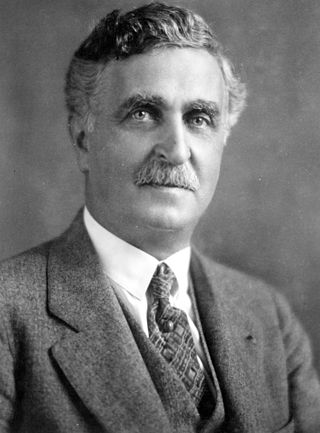
George Otis Smith was an American geologist.

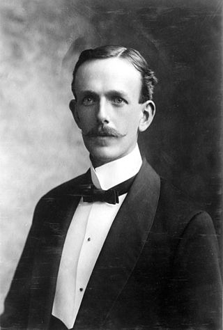
William Embry Wrather was an American geologist.
Robert Thomas Hill was a significant figure in the development of American geology during the late 19th and early 20th centuries. As a pioneer Texas geologist, Hill discovered and named the Comanche series of the Lower Cretaceous, and was a lifelong student of the structure and stratigraphy of the Cretaceous deposits of Central Texas and neighboring regions.

Dallas Lynn Peck was an American geologist and vulcanologist. Peck was a native of Cheney, Washington. He received his bachelor's (1951) and master's (1953) degrees in geology from the California Institute of Technology. He received a doctorate in geology from Harvard University in 1960.

Levi Fatzinger Noble was an American geologist. His entire career was spent as a member of the United States Geological Survey (USGS). Noble is largely known for his work in the American southwest, particularly as a pioneer geologist in the Death Valley region.
Richard Urquhart Goode was an American geographer and topographer with the United States Geological Survey, Northern Transcontinental Railroad Survey, and the Panama Canal Company.

The United States Geological Survey (USGS), formerly simply known as the Geological Survey, is a scientific agency of the United States government. The scientists of the USGS study the landscape of the United States, its natural resources, and the natural hazards that threaten it. The organization's work spans the disciplines of biology, geography, geology, and hydrology. The USGS is a fact-finding research organization with no regulatory responsibility. The agency was founded on March 3, 1879. It is now chaired by David Applegate.
Israel Charles White was an eminent geologist and professor, internationally known, and the first state geologist of West Virginia.

The Mancos Shale or Mancos Group is a Late Cretaceous geologic formation of the Western United States.
The Hueco Formation is a geologic formation in west Texas and southern New Mexico. It preserves fossils dating back to the early Permian period.

The El Paso Formation is a geologic formation that is exposed from the Permian Basin of New Mexico and Texas to southeastern Arizona. It preserves fossils dating back to the Ordovician period.

The Wasatch Formation (Tw) is an extensive highly fossiliferous geologic formation stretching across several basins in Idaho, Montana Wyoming, Utah and western Colorado. It preserves fossils dating back to the Early Eocene period. The formation defines the Wasatchian or Lostcabinian, a period of time used within the NALMA classification, but the formation ranges in age from the Clarkforkian to Bridgerian.

The Mesaverde Group is a Late Cretaceous stratigraphic group found in areas of Colorado, New Mexico, Utah, and Wyoming, in the Western United States.

Siemon William Muller was an American paleontologist and geologist, known for his studies on Triassic paleontology and stratigraphy, and for his work on permafrost.

Henry Gardiner Ferguson was an American geologist with the United States Geological Survey (USGS). He worked primarily in Nevada and was a pioneer in the geology of the central Great Basin, producing many publications, including multiple USGS geological maps of central Nevada. Ferguson was a lifelong friend and colleague of Levi Noble, a mentor to Ralph Roberts, and worked extensively with Siemon Muller. Along with his wife Alice Ferguson, he helped found the Moyaone Reserve community in Accokeek, Maryland.
References
- Notes
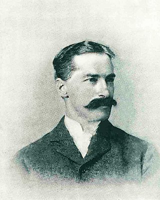
- ↑ Richards RW. Memorial to George Burr Richardson. Proceedings Volume of The Geological Society of America Annual Report for 1951 July 1952: 135-140.
- ↑ Richards RW. Memorial to George Burr Richardson. Proceedings Volume of The Geological Society of America Annual Report for 1951 July 1952: 135-140.
- ↑ Richards RW. Memorial to George Burr Richardson. Proceedings Volume of The Geological Society of America Annual Report for 1951 July 1952: 135-140.
- ↑ Richards RW. Memorial to George Burr Richardson. Proceedings Volume of The Geological Society of America Annual Report for 1951 July 1952: 135-140.
- ↑ Richards RW. Memorial to George Burr Richardson. Proceedings Volume of The Geological Society of America Annual Report for 1951 July 1952: 135-140.
- ↑ Richards RW. Memorial to George Burr Richardson. Proceedings Volume of The Geological Society of America Annual Report for 1951 July 1952: 135-140.
- ↑ Richardson GB. The upper red beds of the Black Hills. Journal of Geology 1903;10:700-702.
- ↑ Brooks AH, Richardson GB, Collier AJ. A reconnaissance of the Cape Nome and adjacent gold fields of Seward Peninsula, Alaska, in 1900. In: Reconnaissances in the Cape Nome and Norton Bay regions, Alaska, in 1900. USGS, special publication 1901: 1-180.
- ↑ Richards RW. Memorial to George Burr Richardson. Proceedings Volume of The Geological Society of America Annual Report for 1951 July 1952: 135-140.
- ↑ Richardson GB. The misnamed Indiana anticline, Pennsylvania. Journal of Geology 1903;10:700-702.
- ↑ Richardson GB. Description of the Indiana quadrangle, Pennsylvania. In: Geologic Atlas, Indiana folio 102, USGS 1904.
- ↑ Richardson GB. Geology and coal, oil and gas resources of the new Kensington quadrangle, Pennsylvania. Bulletin 829, USGS 1932.
- ↑ Richardson GB. Description of the Somerset and Windber quadrangles, Pennsylvania. In: Geologic Atlas, Somerset-Windber folio 224, USGS 1935.
- ↑ Richardson GB. Geology and mineral resources of the Butler and Zellienople quadrangles, Pennsylvania. Bulletin 873. USGS 1936
- ↑ Richardson GB. Report of a reconnaissance in trans-Pecos Texas, north of the Texas and Pacific Railway. Mineral Survey, Bulletin 9, University of Texas 1904.
- ↑ Richardson GB. Description of the El Paso quadrangle, Texas. In: Geologic Atlas, El Paso folio 166. USGS 1909.
- ↑ Richardson GB. Description of the Van Horn quadrangle, Texas. In: Geologic Atlas, Van Horn folio 194. USGS 1914.
- ↑ Richardson GB. Underground water in the valleys of Utah Lake and Jordan river, Utah. Water Supply Paper 157, USGS 1906.
- ↑ Richardson GB. Underground water in Sanpete and central Sevier valley, Utah. Water Supply Paper 199, USGS 1907.
- ↑ Richardson GB. The Book Cliffs coal fields, between Grand River, Colorado, and Sunnyside, Utah. Bulletin 316. USGS 1907.
- ↑ Richardson GB. The Book Cliffs coal fields, between Grand River, Colorado, and Sunnyside, Utah. Bulletin 371. USGS 1907.
- ↑ Richardson GB. Coal in Sanpete County, Utah. bulletin 285. USGS 1906.
- ↑ Richardson GB. Natural gas near Salt Lake City, Utah. Bulletin 260. USGS 1905.
- ↑ Richardson GB. Antimony in southern utah. Bulletin 340. USGS 1908.
- ↑ Richardson GB. The Harmony, Colob and Kanab coal fields, southern utah. Bulletin 341. USGS 1909.
- ↑ Richardson GB. Petroleum in southern Utah. Bulletin 340. USGS 1908.
- ↑ Richards RW. Memorial to George Burr Richardson. Proceedings Volume of The Geological Society of America Annual Report for 1951 July 1952: 135-140.
- ↑ Petroleum reserves. In: Energy resources and national policy. Report of the Energy resources committee to the National Resource Committee, H. Doc. 160, pp 286-294.
- ↑ Richards RW. Memorial to George Burr Richardson. Proceedings Volume of The Geological Society of America Annual Report for 1951 July 1952: 135-140.
- ↑ Richards RW. Memorial to George Burr Richardson. Proceedings Volume of The Geological Society of America Annual Report for 1951 July 1952: 135-140.
- ↑ Richards RW. Memorial to George Burr Richardson. Proceedings Volume of The Geological Society of America Annual Report for 1951 July 1952: 135-140.
- ↑ Richards RW. Memorial to George Burr Richardson. Proceedings Volume of The Geological Society of America Annual Report for 1951 July 1952: 135-140.
- ↑ Richards RW. Memorial to George Burr Richardson. Proceedings Volume of The Geological Society of America Annual Report for 1951 July 1952: 135-140.
- Bibliography
- Richards RW. Memorial to George Burr Richardson. Proceedings Volume of The Geological Society of America Annual Report for 1951 July 1952: 135-140.
- Brooks AH, Richardson GB, Collier AJ. A reconnaissance of the Cape Nome and adjacent gold fields of Seward Peninsula, Alaska, in 1900. In: Reconnaissances in the Cape Nome and Norton Bay regions, Alaska, in 1900. USGS, special publication 1901: 1-180.
- Richardson GB. The upper red beds of the Black Hills. Journal of Geology 1903;10:700-702.
- Richardson GB. Description of the Indiana quadrangle, Pennsylvania. In: Geologic Atlas, Indiana folio 102, USGS 1904.
- Richardson GB. Geology and coal, oil and gas resources of the new Kensington quadrangle, Pennsylvania. Bulletin 829, USGS 1932.
- Richardson GB. Description of the Somerset and Windber quadrangles, Pennsylvania. In: Geologic Atlas, Somerset-Windber folio 224, USGS 1935.
- Richardson GB. Geology and mineral resources of the Butler and Zellienople quadrangles, Pennsylvania. Bulletin 873. USGS 1936
- Richardson GB. Report of a reconnaissance in trans-Pecos Texas, north of the Texas and Pacific Railway. Mineral Survey, Bulletin 9, University of Texas 1904.
- Richardson GB. Description of the El Paso quadrangle, Texas. In: Geologic Atlas, El Paso folio 166. USGS 1909.
- Richardson GB. Description of the Van Horn quadrangle, Texas. In: Geologic Atlas, Van Horn folio 194. USGS 1914.
- Richardson GB. Underground water in the valleys of Utah Lake and Jordan river, Utah. Water Supply Paper 157, USGS 1906.
- Richardson GB. Underground water in Sanpete and central Sevier valley, Utah. Water Supply Paper 199, USGS 1907.
- Richardson GB. The Book Cliffs coal fields, between Grand River, Colorado, and Sunnyside, Utah. Bulletin 316. USGS 1907.
- Richardson GB. Reconnaissance of the Book Cliffs coal field between Grand River, Colorado, and Sunnyside, Utah. Bulletin 371. USGS 1909.
- Richardson GB. Coal in Sanpete County, Utah. bulletin 285. USGS 1906.
- Richardson GB. Natural gas near Salt Lake City, Utah. Bulletin 260. USGS 1905.
- Richardson GB. Antimony in southern Utah. Bulletin 340. USGS 1908.
- Richardson GB. The Harmony, Colob and Kanab coal fields, southern Utah. Bulletin 341. USGS 1909.
- Richardson GB. Petroleum in southern Utah. Bulletin 340. USGS 1908.
- Petroleum reserves. In: Energy resources and national policy. Report of the Energy resources committee to the National Resource Committee, H. Doc. 160, pp 286–294.
| International | |
|---|---|
| National | |
| Other | |