
Parramatta is a suburb and major commercial centre in Greater Western Sydney, located in the state of New South Wales, Australia. It is located approximately 24 kilometres (15 mi) west of Central Sydney, on the banks of the Parramatta River. Parramatta is the administrative seat of the local government area of the City of Parramatta and is often regarded as the main commercial centre of Greater Western Sydney Metropolitan area. Parramatta also has a long history as a second administrative centre in the Sydney metropolitan region, playing host to a number of state government departments as well as state and federal courts. It is often colloquially referred to as "Parra".
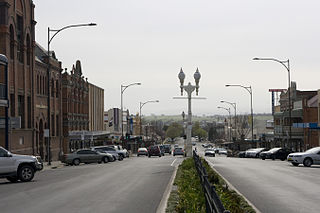
Bathurst is a city in the Central Tablelands of New South Wales, Australia. Bathurst is about 200 kilometres (120 mi) west-northwest of Sydney and is the seat of the Bathurst Regional Council. Bathurst is the oldest inland settlement in Australia and had a population of 37,191 in June 2019.

Richmond is a town in New South Wales, in the local government area of the City of Hawkesbury. It is located 19 metres above sea level on the alluvial Hawkesbury River flats, at the foot of the Blue Mountains on the Cumberland Plain. It is about 65 km by road from Sydney and about 78 km by road from Lithgow.

Branxton is a town in the Hunter Region of New South Wales, Australia. Branxton is 171 kilometres (106 mi) north of Sydney via the Sydney-Newcastle Freeway and New England Highway. Branxton is located mostly in the City of Cessnock, but part of it is in Singleton Shire. It had a population of 1,991 at the 2016 census.

Windsor is a historic town north-west of Sydney, New South Wales, Australia. It is the council seat of the Hawkesbury local government area. The town sits on the Hawkesbury River, enveloped by farmland and Australian bush. Many of the oldest surviving European buildings in Australia are located at Windsor. It is 46 kilometres (29 mi) north-west of metropolitan Sydney, on the fringes of urban sprawl.

Burwood is a suburb in the Inner West of Sydney, in the state of New South Wales, Australia. It is 10 kilometres (6.2 mi) west of the Sydney central business district and is the administrative centre for the local government area of Municipality of Burwood. People from Burwood are colloquially known as Burwoodiens or Burwooders.

The City of Blue Mountains is a local government area of New South Wales, Australia, governed by the Blue Mountains City Council. The city is located in the Blue Mountains, on the Great Dividing Range at the western edge of the Greater Sydney Region in New South Wales, Australia.

Kelso is a suburb of Bathurst, New South Wales, Australia, in the Bathurst Regional Council area.
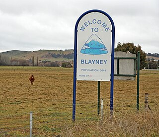
Blayney is a farming town and administrative centre with a population of 3,378 in 2016, in the Central West region of New South Wales, Australia. Situated on the Mid-Western Highway about 240 km (150 mi) west of Sydney, 35 km (22 mi) west of Bathurst and 863 m (944 yd) above sea-level, Blayney is the seat of Blayney Shire Council.
East Maitland is a suburb in the City of Maitland, New South Wales, Australia. It is on the New England Highway and it has two railway stations, Victoria Street and East Maitland. Both stations are served by NSW TrainLink's Hunter Line. Hunter Valley Buses provides bus service.

Woodford is a village in the Blue Mountains in New South Wales, Australia, about 90 kilometres west of Sydney. Its elevation is 609 metres (1,998 ft) above sea level. It is situated on the Great Western Highway and has a railway station on the Main Western railway line served by NSW TrainLink's Blue Mountains services. At the 2016 census, Woodford had a population of 1,934.
Bowenfels is a small town on the western outskirts of Lithgow, New South Wales, Australia.
Rydal is a small rural village in New South Wales, Australia.

O’Connell is a village in New South Wales, Australia. The village, classified by the National Trust of Australia, is 23 kilometres from Oberon on the O'Connell Road. At the 2006 census, O'Connell and the surrounding area had a population of 355.

Blayney railway station is a heritage-listed railway station on the Main Western line in Blayney, Blayney Shire, New South Wales, Australia. The property was added to the New South Wales State Heritage Register on 2 April 1999.

Rydal railway station is a heritage-listed railway station located on the Main Western line in Rydal, City of Lithgow, New South Wales, Australia. It is also known as Rydal Railway Station group. The property was added to the New South Wales State Heritage Register on 2 April 1999.

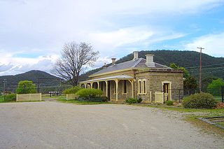
Tarana railway station is a heritage-listed railway station located on the Main Western line in Tarana, City of Lithgow, New South Wales, Australia. It is also known as the Tarana Railway Station and yard group. The property was added to the New South Wales State Heritage Register on 2 April 1999.

The Dubbo Regional Council is a local government area located in the Central West and Orana regions of New South Wales, Australia. The council was formed on 12 May 2016 through a merger of the City of Dubbo and Wellington Council as part of a widespread council amalgamation program. It was initially named Western Plains Regional Council for almost four months, and its name was changed to Dubbo Regional Council on 7 September 2016.
Raglan is a locality in the Bathurst Region of New South Wales, Australia. It was named after FitzRoy Somerset, 1st Baron Raglan, commander-in-chief of the Allied forces in the Crimean War from 1850 to 1855. It had a population of 1,199 people as of the 2016 census.
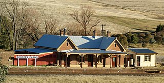
Georges Plains railway station is a heritage-listed former railway station and now private residence located on the Main Western railway at Georges Plains in the Bathurst Region local government area in New South Wales, Australia. The former railway station was added to the New South Wales State Heritage Register on 2 April 1999.
