
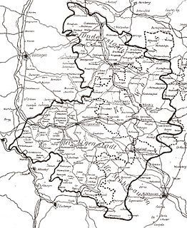
Quedlinburg is a town situated just north of the Harz mountains, in the district of Harz in the west of Saxony-Anhalt, Germany. As an influential and prosperous trading centre during the early Middle Ages, Quedlinburg became a center of influence under the Ottonian dynasty in the 10th and 11th centuries. The castle, church and old town, dating from this time of influence, were added to the UNESCO World Heritage List in 1994 because of their exceptional preservation and outstanding Romanesque architecture.
Eichsfeld is a district in Thuringia, Germany, and part of the historical region of Eichsfeld. It is bounded by the districts of Nordhausen, Kyffhäuserkreis and Unstrut-Hainich-Kreis, and by the states of Hesse and Lower Saxony.
The Kyffhäuserkreis is a district in the northern part of Thuringia, Germany. Neighboring districts are the districts Mansfeld-Südharz, Saalekreis und Burgenlandkreis in Saxony-Anhalt, and the districts Sömmerda, Unstrut-Hainich-Kreis and Eichsfeld.
Nordhausen is a Kreis (district) in the north of Thuringia, Germany. Neighboring districts are : Harz and Mansfeld-Südharz in Saxony-Anhalt; Kyffhäuserkreis and Eichsfeld in Thuringia; and Göttingen and Goslar in Lower Saxony.

Nordhausen is a city in Thuringia, Germany. It is the capital of the Nordhausen district and the urban centre of northern Thuringia and the southern Harz region; its population is 42,000. Nordhausen is located approximately 60 km north of Erfurt, 80 km west of Halle, 85 km south of Braunschweig and 60 km east of Göttingen.

Altenburg is a city in Thuringia, Germany, located 40 kilometres south of Leipzig, 90 kilometres west of Dresden and 100 kilometres east of Erfurt. It is the capital of the Altenburger Land district and part of a polycentric old-industrial textile and metal production region between Gera, Zwickau and Chemnitz with more than 1 million inhabitants, while the city itself has a population of 33,000. Today, the city and its rural county is part of the Central German Metropolitan Region.

Heilbad Heiligenstadt is a spa town in Thuringia, Germany. It is the capital of the Eichsfeld district.
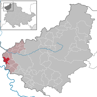
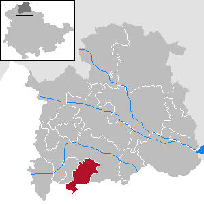
Holungen is a village and a former municipality in the district of Eichsfeld in Thuringia, Germany. Since 1 December 2011, it is part of the municipality Sonnenstein, of which it is an Ortschaft. It lies approximately 35 km (22 mi) from the university town of Göttingen. With a population of around 1,000, it is one of the medium-sized villages in the district.
Dieterode is a municipality in the district Eichsfeld, Thuringia, Germany. It is part of the municipal association Ershausen/Geismar.
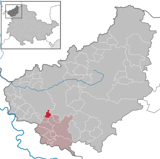
Bornhagen is a municipality in the district of Eichsfeld in Thuringia, Germany, located at the foot of the ruins of Hanstein Castle. The town district Rimbach is positioned directly south of the castle citadel at an elevation of 370 m. Bornhagen is located 22 km south of Göttingen, 85 km northwest of the state capital Erfurt and 270 km southwest of Berlin. It is the westernmost settlement in Thuringia but does not contain the westernmost point which is 75 km south near Geisa.

Gernrode is a historic town and former municipality in the Harz District, in Saxony-Anhalt, Germany. Since 1 January 2014, it has been part of Quedlinburg. It was the seat of the former Verwaltungsgemeinschaft of Gernrode/Harz.
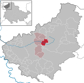
Wingerode is a municipality in the district of Eichsfeld in Thuringia, Germany. In 1996, Wingerode celebrated its 850th anniversary. It was founded in 1146.

Mühlhausen is a city in the north-west of Thuringia, Germany, 5 km north of Niederdorla, the country's geographical centre, 50 km north-west of Erfurt, 65 km east of Kassel and 50 km south-east of Göttingen.

Mansfeld, sometimes also unofficially Mansfeld-Lutherstadt, is a town in the district of Mansfeld-Südharz, in Saxony-Anhalt, Germany.
Großlohra is a municipality in the district of Nordhausen, in Thuringia, Germany, situated on the northern edge of the Hainleite ridge about 20 km (12 mi) southwest of the district capital. It consists of the settlements of Friedrichslohra, Großwenden, Kleinwenden, as well as Münchenlohra with its former convent basilica St. Gangulphus and castle Lohra with its accompanying manor, all of which were united in 1950.

The Halle–Hann. Münden railway is a 218 km long main line operated by the Deutsche Bahn in Germany, which links Halle (Saale) in Saxony-Anhalt with Hann. Münden in the state of Lower Saxony. It is mainly used by regional and east-west goods trains. From 1990 to 1994 it was upgraded as part of a German Unification Transport Project.

Mägdesprung is a village in the municipality of Harzgerode in the district of Harz. It nestles in the Harz Mountains at a height of 295 m.

Leinefelde station is a major railway junction in the German state of Thuringia and is the most important station in Eichsfeld. It is located in the town of Leinefelde in the Thuringian municipality of Leinefelde-Worbis in the Eichsfeld district. The Halle–Kassel and Gotha–Leinefelde railways meet there and in the past the now closed Leinefelde–Wulften and Leinefelde–Treysa railways also connected with the station. The latter route was part of the Kanonenbahn between Berlin and Metz.
Eichsfeld II is an electoral constituency represented in the Landtag of Thuringia. It elects one member via first-past-the-post voting. Under the current constituency numbering system, it is designated as constituency 2. It comprises the eastern part of the district of Eichsfeld.
Kyffhäuserkreis I – Eichsfeld III is an electoral constituency represented in the Landtag of Thuringia. It elects one member via first-past-the-post voting. Under the current constituency numbering system, it is designated as constituency 10. It covers the western part of Kyffhäuserkreis and a small part of Eichsfeld district.


