Giewont

Last updated • 4 min readFrom Wikipedia, The Free Encyclopedia
Giewont
Giewont T58.jpg
Highest point
Elevation 1,894 m (6,214 ft) [1] [2] [a]
Prominence 170 m (560 ft)  OOjs UI icon edit-ltr-progressive.svg
Isolation 1.31 km (0.81 mi)  OOjs UI icon edit-ltr-progressive.svg
Listing Mountains of Poland
Coordinates 49°15′02″N19°56′02″E / 49.25056°N 19.93389°E / 49.25056; 19.93389
Geography
Lesser Poland Voivodeship Relief location map.svg
Red triangle with thick white border.svg
Giewont
Location in Poland
Relief Map of Poland.svg
Red triangle with thick white border.svg
Giewont
Giewont (Poland)
Location Lesser Poland, Poland
Parent range Western Tatras, Tatra Mountains
Climbing
First ascent 1830 by Franciszek Herbich and Aleksander Zawadzki
Easiest route South

Giewont (Polish pronunciation: [ˈɡʲɛvɔnt] ) is a mountain massif in the Tatra Mountains of Poland. Its highest peak, Great Giewont (Wielki Giewont), is 1,894 metres (6,214 ft) above sea level and one of the highest peaks of the Western Tatras (Polish: Tatry Zachodnie) located entirely within Poland's borders. The mountain is regarded as the symbol of Zakopane, the Polish Tatras and Podhale, which throughout history has been the subject of many legends, poems and works of art.

Contents

Geography

Giewont lies in the area of the Polish Tatra National Park (Tatrzański Park Narodowy). It encompasses three peaks: Small Giewont (Polish: Mały Giewont, 1,728 metres (5,669 ft)), Great Giewont (Wielki Giewont, 1,894 metres (6,214 ft)) and Long Giewont (Długi Giewont, 1,867 metres (6,125 ft)). There is a mountain pass located between Great and Long Giewont, known as Szczerba (1,823 metres (5,981 ft)). It is located between the valleys of Kondratowa, Małej Łąki and Strążyska. [4] The 600 metres (2,000 ft) high northern face of Great Giewont is clearly visible from the nearby town of Zakopane and remains one of the most characteristic features of the panorama of the Polish Tatras. Geologically, Giewont is composed of dolomite and limestone caves, as well as gneiss and granite in the southern section. Giewont's caves include Juhaska Cave, Sleeping Knights' Cave (Polish: Jaskinia Śpiących Rycerzy), Kozia Grota Cave and Ruda Nyża Cave. [5]

Fauna and flora

Tatra chamois Tatra Chamois.jpg
Tatra chamois

A number of Poland's rare species of plants have been recorded in the area including field locoweed, Hoppe's cudweed, halberd willow, leathery grapefern, false orchid, Pedicularis hacqueti, Cerastium latifolium L and Senecio aurantiacus Less. Among notable animal species is Tatra chamois. Giewont is one of few places in Poland where these animals can survive winter. [6]

History

The earliest document mentioning the mountain dates back to the 16th century and mentions a copper mine located in the Gyewant Mountain. The origin of the name remains unclear. It might originate from the German word Gewand (rock formation); however, according to Mariusz Zaruski, the name has its roots like many other names in the Tatras in a family name of Goral people considering the fact that families bearing this name, which, however, could also derive from the German word, still lived in the area [7]

The first recorded ascent to Giewont's summit was undertaken in 1830 by Franciszek Herbich and Aleksander Zawadzki. Mariusz Zaruski completed the first recorded winter ascent in 1904. [8] Nowadays, hiking trails lead to the peak of the mountain, making it a popular hiking destination.

In 1901, a 15 metres (49 ft) tall steel cross was erected on the summit of Great Giewont and quickly became a site of religious pilgrimages as well as a national symbol. It also became a place for many to manifest their political views as was the case in 1982 during the Martial law in Poland when a banner with the logo of the Solidarity appeared on the cross. [9] In 2007, the cross was inscribed on the register of historical monuments of the Lesser Poland Voivodeship. [10]

2019 thunderstorm

The area frequently experiences thunderstorms. On 22 August 2019, four people were killed and over 100 were injured during an unexpected severe thunderstorm. [11] Most of the victims were on Giewont, where lightning struck the metal cross atop the mountain as well as a metal chain near the summit, according to local media. Four people died in Poland, including two children, and one person died in Slovakia. [12] It was the worst disaster on the mountain since 1937. [13]

Cultural significance

In Polish folklore, the mountain is associated with several legends about sleeping knights who will awake when Poland is in danger. [14] The profile of the mountain resembles a lying knight, wherein the Long Giewont is the knight's torso, and the Great Giewont is the knight's face as viewed from the side (the three 'peaks' representing the chin, the nose, and the eyebrow). The image of Giewont as viewed from the north makes the profile easy to discern. [14] This image of the mountain was further ingrained in the collective consciousness of the nation thanks to an 1880 poem by Adam Asnyk. [15] It proved to be a source of inspiration for many other renowned artists and writers, including Leon Wyczółkowski and Stanisław Ignacy Witkiewicz. In 1875, it officially appeared for the first time on the seal of the city of Zakopane. [9]

In 1880, painter and photographer Walery Eljasz Radzikowski described the mountain in the following words: "Giewont is visible from every cottage, therefore it deservedly holds the title of the King of Zakopane". [7]

See also

Notes

  1. According to the most recent measurement [3] by a Polish government body, Giewont has an altitude of 1,894.82 metres (6,216.6 ft), with most sources rounding this down to 1,894 metres (6,214 ft) a.s.l.

Related Research Articles

<span class="mw-page-title-main">Zakopane</span> Place in Lesser Poland Voivodeship, Poland

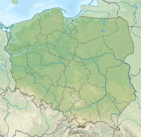
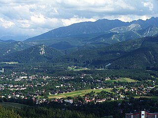
Zakopane is a town in the south of Poland, in the southern part of the Podhale region at the foot of the Tatra Mountains. From 1975 to 1998, it was part of Nowy Sącz Voivodeship; since 1999, it has been part of Lesser Poland Voivodeship. As of 2017 its population was 27,266. Zakopane is a centre of Goral culture and is often referred to as "the winter capital of Poland". It is a popular destination for mountaineering, skiing, and tourism.

<span class="mw-page-title-main">Tatra Mountains</span> Mountain range on the Polish–Slovak border

The Tatra Mountains, Tatras, are a series of mountains within the Western Carpathians that form a natural border between Slovakia and Poland. They are the highest mountains in the Carpathians. The Tatras are distinct from the Low Tatras, a separate Slovak mountain range further south.

<span class="mw-page-title-main">Rysy</span> Mountain in the High Tatras

Rysy is a mountain in the crest of the High Tatras, eastern part of the Tatra Mountains, lying on the border between Poland and Slovakia. Rysy has three summits: the middle at 2,501 m (8,205 ft); the north-western at 2,500 m (8,202 ft); and the south-eastern at 2,473 m (8,114 ft). The north-western summit is the highest point of Poland and belongs to the Crown of Polish Mountains; the other two summits are on the Slovak side of the border.

<span class="mw-page-title-main">Gerlachovský štít</span> Highest mountain in Slovakia

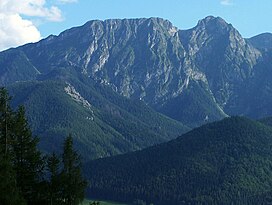
Gerlachovský štít, informally referred to as Gerlach, is the highest peak in the High Tatras, in Slovakia, and in the Carpathian Mountains. Its elevation is usually listed at 2654.4 m above mean sea level. The mountain features a vertical rise of approximately 2,000 metres (6,600 ft) above the valley floor.

<span class="mw-page-title-main">Western Tatras</span> Mountain range in Europe

The Western Tatras are mountains in the Tatras, part of the Carpathian Mountains, located on the Polish-Slovak border. The mountains border the High Tatras in the east, Podtatranská kotlina in the south, Choč Mountains in the west and Rów Podtatrzański in the north. The main ridge is 37 kilometers long and the mountain range contains 31 two-thousanders.

<span class="mw-page-title-main">High Tatras</span> Mountain range along the border of Slovakia and Poland

The High Tatras or High Tatra Mountains, are a mountain range along the border of northern Slovakia in the Prešov Region, and southern Poland in the Lesser Poland Voivodeship. They are a range of the Tatra Mountains chain.

<span class="mw-page-title-main">Gorals</span> Ethnic group of Central Europe

The Gorals, also anglicized as the Highlanders and historically also as Vlachs, are an ethnographic group primarily found in their traditional area of southern Poland, northern Slovakia, and in the region of Cieszyn Silesia in the Czech Republic, where they are known as the Silesian Gorals. There is also a significant Goral diaspora in the area of Bukovina in western Ukraine and in northern Romania, as well as in Chicago, the seat of the Polish Highlanders Alliance of North America.

<span class="mw-page-title-main">Tatra National Park, Poland</span>

Tatra National Park is a national park located in the Tatra Mountains in Tatra County, in the Lesser Poland Voivodeship in central-southern Poland. The park is headquartered in the town of Zakopane.

<span class="mw-page-title-main">Morskie Oko</span> Lake in the Tatra Mountains, southern Poland

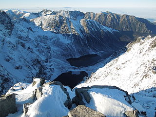
Morskie Oko, or Eye of the Sea in English, is the largest and fourth-deepest lake in the Tatra Mountains, in southern Poland. It is located deep within the Tatra National Park in the Rybi Potok Valley, of the High Tatras mountain range at the base of the Mięguszowiecki Summits, in Lesser Poland Voivodeship. In 2014, The Wall Street Journal recognized the lake as one of the five most beautiful lakes in the world.

<span class="mw-page-title-main">Jaskinia Wielka Śnieżna</span>

Jaskinia Wielka Śnieżna is a limestone cave system in Mount Małołączniak in the Western Tatra Mountains, of the Carpathian Mountains System, in southern Poland. The cave is within Tatra National Park.

<span class="mw-page-title-main">Łysa Góra</span> Mountain in Poland

Łysa Góra, translated as Bald Mountain, is a well-known hill in Świętokrzyskie Mountains, Poland. With a height of 595 metres (1,952 ft), it is the second highest point in that range. On its slopes and atop its summit are several hiking trails, the ruins of a pagan wall from 9th century, the Benedictine monastery from the 11th century, and the Święty Krzyż TV Tower. The mountain also features prominently in a local legend about witches' sabbaths.

<span class="mw-page-title-main">Mariusz Zaruski</span> Polish general (1867–1941)

Mariusz Zaruski was a brigadier-general in the Polish Army, a pioneer of Polish sports yachting, an outstanding climber of the winter and caves of Tatra Mountains. He was a photographer, painter, poet and writer, a seamen and traveler, a conspirator, legionnaire and lancer in Polish cavalry.

<span class="mw-page-title-main">Tatra Volunteer Search and Rescue</span>

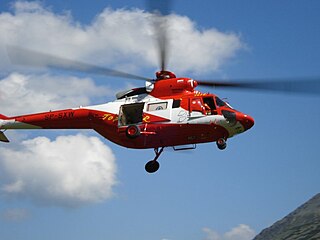
Tatra Volunteer Search and Rescue is a non-profit mountain rescue organization in Poland, rescuing stranded mountain climbers, tourists, and others in need of rescue in the Polish Tatra mountains. It is one of the oldest mountain rescue associations in the world.

<span class="mw-page-title-main">Sabała</span>

Sabała or Sablik was a Goral amateur musician, storyteller and folk singer active in or around the Tatra Mountains. A friend to many renowned Polish artists of the late 19th century, he is featured in numerous Polish works of art of the epoch.

<span class="mw-page-title-main">Crown of Polish Mountains</span>

Crown of Polish Mountains – a list of 28 peaks one per each of the mountain ranges of Poland. It was suggested by geographer, traveller and writer Marek Więckowski and Dr. Wojciech Lewandowski in the tourism and local lore magazine Know Your Country. The list was on December 12, 1997 at a meeting convened by the editors of Know Your Country and at the same time the Club of the Conquerors of the Crown of Polish Mountains was inaugurated.

<span class="mw-page-title-main">Kościeliska Valley</span>

The Kościeliska is a valley in Poland, in Tatra Mountains, Western Tatras, Poland. It stretches from the village of Kiry, about 9 km, right up to the main ridge of the Tatras. Halfway up is the Ornak mountain refuge, built in 1948. Is reached by road from Zakopane - 7 km.

<span class="mw-page-title-main">Klemens Bachleda</span> Polish mountain guide

Klemens "Klimek" Bachleda was a pioneering Polish mountain guide and mountain rescuer in Austria-Hungary. He died during an unsuccessful mountain rescue attempt in the High Tatras.

<span class="mw-page-title-main">2003 Tatra Mountains avalanche</span> Avalanche in the Tatra Mountains

The 2003 Tatra Mountains avalanche was an avalanche that occurred on 28 January 2003, sweeping away nine out of a thirteen-member group heading to the summit of Rysy in the Tatra Mountains. The participants of the trip were students from the Leon Kruczkowski High School in Tychy and individuals associated with the school's sports club Pion.

<span class="mw-page-title-main">Wanda Gentil-Tippenhauer</span> Polish painter and skier (1899-1965)

Wanda Anna Gentil-Tippenhauer Widigierowa, aka Ruda Wanda (1899-1965) was a Polish painter, a passionate skier and a Tatra Mountains devotee.

References

  1. "Skąd się wziął krzyż na Giewoncie?". Onet Podróże (in Polish). 2022-11-20. Archived from the original on 2023-02-01. Retrieved 2023-05-11.
  2. "Topographic map of Giewont". opentopomap.org. Retrieved 2023-07-04.
  3. "Giewont". geoportal.gov.pl.
  4. Radwańska-Paryska, Zofia; Paryski, Witold Henryk (1995). Wielka encyklopedia tatrzańska. Poronin: Wydawnictwo Górskie. ISBN   978-83-7104-009-2.
  5. "Jaskinie Polski" (in Polish). Retrieved 2020-12-18.
  6. "Przyrodnicy kontra taternicy - Nie będziemy w jednym gnieździe spali" (in Polish). Archived from the original on 2013-09-25. Retrieved 2020-12-18.
  7. 1 2 "Na bezdrożach tarzańskich" (in Polish). Archived from the original on 2016-12-23. Retrieved 2020-12-18.
  8. Baraniak, Krzysztof (2014-09-05). "Tatrzańskie szczyty: GIEWONT". Tatromaniak - Serwis Miłośników Tatr (in Polish). Archived from the original on 2023-02-05. Retrieved 2023-05-28.
  9. 1 2 "Skąd się wziął krzyż na Giewoncie?" (in Polish). Retrieved 2020-12-18.
  10. "Symbol polskich Tatr. Skąd się wziął krzyż na Giewoncie?" (in Polish). Retrieved 2020-12-18.
  11. "Poland lightning strike kills four, injures 100, in Tatra mountains storm" . Retrieved 18 December 2020.
  12. "Z krzyża na skały, ze skał na łańcuch. Tak piorun na Giewoncie raził turystów" (in Polish). 23 August 2019. Retrieved 2020-12-18.
  13. "BURZA W TATRACH. NAJWIĘKSZA TRAGEDIA NA GIEWONCIE OD 1937 ROKU" (in Polish). Retrieved 2020-12-18.
  14. 1 2 Baraniak, Krzysztof (2014-08-15). "Legenda o śpiących rycerzach". TATROMANIAK - Serwis Miłośników Tatr (in Polish). Archived from the original on 2023-04-07. Retrieved 2023-05-21.
  15. Guzek, Paweł (2014-12-06). "Giewont w poezji i kulturze". Portal Górski (in Polish). Archived from the original on 2017-06-29. Retrieved 2023-05-21.

References