List of buildings
| Name | Location | Type | Completed [note 1] | Date designated | Grid ref. [note 2] Geo-coordinates | Entry number [note 3] | Image |
|---|---|---|---|---|---|---|---|
| Church of St Mary | Adderbury East, Adderbury | Church | Early 13th century | 8 December 1955 | SP4708935378 52°00′53″N1°18′55″W / 52.014838°N 1.315277°W | 1200012 | 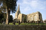 |
| Church of St Mary | Banbury | Church | c.1790 | 9 April 1952 | SP4540840551 52°03′41″N1°20′21″W / 52.061483°N 1.339084°W | 1369519 |  |
| Church of St Michael | Barford St Michael | Church | c.1150 | 8 December 1955 | SP4327032610 51°59′25″N1°22′17″W / 51.990263°N 1.371269°W | 1284140 | 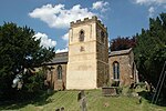 |
| Church of St Edburg | Bicester | Church | 11th century | 31 January 1952 | SP5830222278 51°53′46″N1°09′15″W / 51.896009°N 1.154128°W | 1199769 |  |
| Church of St Mary | Bloxham | Church | 12th century | 8 December 1955 | SP4301135679 52°01′04″N1°22′29″W / 52.017874°N 1.374656°W | 1284130 | 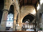 |
| Broughton Castle and attached walls | Broughton | Manor house | 14th century | 8 December 1955 | SP4180938173 52°02′25″N1°23′31″W / 52.040387°N 1.391867°W | 1248742 | 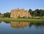 |
| Broughton Castle, gatehouse, bridge and curtain wall | Broughton | Gatehouse | 14th century | 8 December 1955 | SP4180438242 52°02′28″N1°23′31″W / 52.041008°N 1.391931°W | 1248762 | 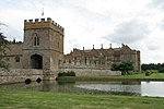 |
| Broughton Castle, stable block | Broughton | Stable | 15th century | 8 December 1955 | SP4184438246 52°02′28″N1°23′29″W / 52.041041°N 1.391347°W | 1277775 |  |
| Church of St Mary the Virgin | Broughton | Church | c.1300 | 8 December 1955 | SP4186138321 52°02′30″N1°23′28″W / 52.041714°N 1.39109°W | 1248778 | 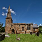 |
| Church of St Peter | Bucknell | Church | 11th/12th century | 7 December 1966 | SP5608425599 51°55′34″N1°11′09″W / 51.926092°N 1.185819°W | 1200258 |  |
| Church of St Mary the Virgin | Charlton-on-Otmoor | Church | 13th and 14th century | 7 December 1966 | SP5619415815 51°50′17″N1°11′09″W / 51.838123°N 1.185809°W | 1370086 | 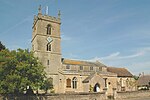 |
| Old Manor Farmhouse | Cottisford | Farmhouse | 13th/14th century | 26 November 1951 | SP5892231082 51°58′30″N1°08′37″W / 51.97509°N 1.143614°W | 1046440 |  |
| Church of St Mary the Virgin | Cropredy | Church | 13th century | 8 December 1955 | SP4689946668 52°06′59″N1°18′59″W / 52.116351°N 1.316498°W | 1216164 |  |
| The Leadenporch House | Deddington | Farmhouse | Early 14th century | 8 December 1955 | SP4668031405 51°58′45″N1°19′18″W / 51.979155°N 1.321776°W | 1300760 |  |
| Chapel at Water Eaton Manor House | Water Eaton | Domestic chapel | c.1600 | 7 December 1966 | SP5156712104 51°48′19″N1°15′13″W / 51.805206°N 1.25351°W | 1046563 |  |
| Church of St Peter | Hanwell | Church | 13th century | 8 December 1955 | SP4357243575 52°05′20″N1°21′56″W / 52.088816°N 1.365477°W | 1216364 |  |
| Church of St Peter | Hook Norton | Church | 12th century [1] | 8 December 1955 | SP3551233125 51°59′44″N1°29′03″W / 51.995442°N 1.48419°W | 1369840 | 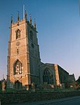 |
| Church of St Ethelreda | Horley | Church | 12th century | 8 December 1955 | SP4168543965 52°05′33″N1°23′35″W / 52.092467°N 1.392969°W | 1216504 | 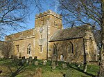 |
| Church of St John the Baptist | Hornton | Church | 12th century | 8 December 1955 | SP3922245005 52°06′07″N1°25′44″W / 52.101996°N 1.428798°W | 1227940 | 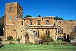 |
| Church of St Nicholas | Islip | Church | 11th century | 7 December 1966 | SP5265214095 51°49′23″N1°14′15″W / 51.823005°N 1.237474°W | 1046574 | 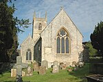 |
| Church of St Mary | Kidlington | Church | 12th century | 7 December 1966 | SP4972314809 51°49′47″N1°16′48″W / 51.829691°N 1.279864°W | 1291046 |  |
| Kirtlington Park | Kirtlington | Country house | 1742–46 | 26 November 1951 | SP5082219833 51°52′29″N1°15′47″W / 51.874759°N 1.263181°W | 1200202 |  |
| Church of the Assumption of the Blessed Virgin Mary | Launton | Church | Late 12th century | 7 December 1966 | SP6043822827 51°54′03″N1°07′23″W / 51.900718°N 1.122995°W | 1369735 |  |
| Church of St Swithun | Merton | Church | 13th century | 7 December 1966 | SP5773717816 51°51′21″N1°09′47″W / 51.855955°N 1.163083°W | 1369750 |  |
| Middleton Park | Middleton Stoney | Country house | 1938 | 26 November 1951 | SP5249223237 51°54′19″N1°14′18″W / 51.905207°N 1.238409°W | 1232948 | |
| Church of St Michael and All Angels | Alkerton | Church | c.1200 | 8 December 1955 | SP3772142924 52°05′00″N1°27′03″W / 52.083392°N 1.45094°W | 1300845 |  |
| Church of St James | Somerton | Church | 12th century | 7 December 1966 | SP4968828631 51°57′14″N1°16′42″W / 51.953956°N 1.278385°W | 1225707 | 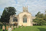 |
| Churchyard cross approximately 12 metres north of church of St James | Somerton | Cross | Medieval | 26 February 1988 | SP4970428645 51°57′15″N1°16′41″W / 51.954081°N 1.278151°W | 1225734 |  |
| Church of St Peter ad Vincula | South Newington | Church | 12th century | 8 December 1955 | SP4074733338 51°59′49″N1°24′29″W / 51.996999°N 1.407923°W | 1277633 | 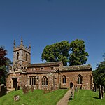 |
| Church of St Mary and St Edburga | Stratton Audley | Church | 14th and 15th century | 7 December 1966 | SP6085826036 51°55′46″N1°06′59″W / 51.92952°N 1.116325°W | 1046404 |  |
| Church of St Peter and St Paul | Swalcliffe | Church | Saxon | 8 December 1955 | SP3785737892 52°02′17″N1°26′58″W / 52.038144°N 1.449512°W | 1199016 | 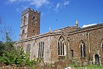 |
| Manor House | Swalcliffe | Hall house | 13th century | 8 December 1955 | SP3780537905 52°02′18″N1°27′01″W / 52.038265°N 1.450268°W | 1046268 | |
| Tithe Barn | Swalcliffe | Tithe barn | c.1400 | 8 December 1955 | SP3774537919 52°02′18″N1°27′04″W / 52.038395°N 1.451142°W | 1046267 | 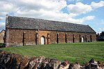 |
| Church of St Nicholas | Tadmarton | Church | 12th century | 8 December 1955 | SP3923837856 52°02′16″N1°25′46″W / 52.037725°N 1.429384°W | 1369852 | 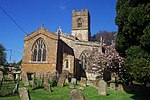 |
| Tithe Barn approximately 30 metres south of Manor Farmhouse | Upper Heyford | Tithe barn | c.1400 | 26 November 1951 | SP4944425812 51°55′43″N1°16′56″W / 51.928635°N 1.28234°W | 1266058 |  |
| Church of St Mary Magdalene | Wardington | Church | 12th century | 8 December 1955 | SP4911246334 52°06′47″N1°17′03″W / 52.113156°N 1.28423°W | 1228671 | 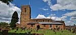 |
| Church of Saint Giles | Wigginton | Church | 13th century | 8 December 1955 | SP3907733282 51°59′48″N1°25′56″W / 51.996615°N 1.432252°W | 1052175 | 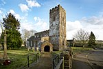 |
| Wroxton College and attached walls and steps | Wroxton | Country house | c.1618 | 8 December 1955 | SP4166141622 52°04′17″N1°23′37″W / 52.071405°N 1.393605°W | 1046769 |  |
| Church of St Bartholomew | Yarnton | Church | 12th century | 7 December 1966 | SP4776711676 51°48′06″N1°18′31″W / 51.801695°N 1.308677°W | 1290230 | 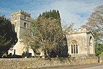 |


