
Grand Junction is a home rule municipality that is the county seat and the most populous municipality of Mesa County, Colorado, United States. The city has a council–manager form of government, and is the most populous municipality in all of western Colorado. Grand Junction is 247 miles (398 km) west-southwest of the Colorado State Capitol in Denver. As of the 2010 census, the city's population was 58,566. Grand Junction is the 15th most populous city in the state of Colorado and the most populous city on the Colorado Western Slope. It is a major commercial and transportation hub within the large area between the Green River and the Continental Divide. It is the principal city of the Grand Junction Metropolitan Statistical Area, which had a population of 146,723 in 2010 census.
Grand Junction may refer to:
U.S. Route 26 is an east–west United States highway that started in Ogallala, Nebraska. Later, it was subsequently extended to the West Coast in Oregon. When the U.S. highway system was first defined, it was limited to Nebraska and Wyoming; by the 1950s, it continued into Idaho and Oregon. The highway's eastern terminus is in Ogallala, Nebraska at an intersection with Interstate 80. Its western terminus is south of Seaside, Oregon at an intersection with U.S. Route 101. Prior to 2004, the route's last 20 miles (32 km) were co-signed with U.S. Route 101 from the highways' junction south of Seaside north to Astoria where its intersection with U.S. Route 30 was also U.S. 30's western terminus. Long segments of the highway follow the historic Oregon Trail. At its peak, immediately before the establishment of the interstate highway system, US 26 was 1,557 miles (2506 km) in length, and terminated in Astoria, Oregon.

The Boise City–Nampa, Idaho Metropolitan Statistical Area (MSA) is an area that encompasses Ada, Boise, Canyon, Gem, and Owyhee counties in southwestern Idaho. It is distinct from the wider Boise City–Mountain Home–Ontario, ID–OR Combined Statistical Area, an area consisting of seven counties in southwestern Idaho, and Malheur County, Oregon anchored by the cities of Boise and Nampa. It is the state's largest officially designated metropolitan area and includes Idaho's three largest cities – Boise, Nampa, and Meridian. Nearly 40 percent of Idaho's total population lives in the area.

U.S. Route 89 is a north–south United States Numbered Highway with two sections, and one former section. The southern section runs for 848 miles (1,365 km) from Flagstaff, Arizona, to the southern entrance of Yellowstone National Park. The northern section runs for 404 miles (650 km) from the northern entrance of Yellowstone National Park in Montana, ending at the Canadian border. Unnumbered roads through Yellowstone connect the two sections. Before 1992, US 89 was a Canada–Mexico, border-to-border highway that ended at Nogales, Arizona, on its southern end.

U.S. Route 191 is a spur of U.S. Route 91 that has two branches. The southern branch runs for 1,465 miles (2,358 km) from Douglas, Arizona on the Mexican border to the southern part of Yellowstone National Park. The northern branch runs for 440 miles (710 km) from the northern part of Yellowstone National Park to Loring, Montana, at the Canada–US border. Unnumbered roads within Yellowstone National Park connect the two branches. The highway passes through the states of Arizona, Utah, Wyoming, and Montana.
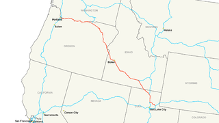
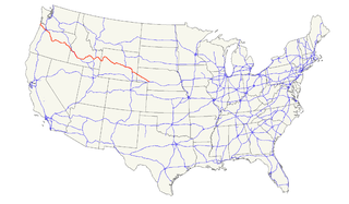
Interstate 84 (I-84) is an Interstate Highway in the northwestern United States. The highway runs from Portland, Oregon, to a junction with I-80 near Echo, Utah. The sections running through Oregon and Idaho are also known as the Vietnam Veterans Memorial Highway. The highway originally served as a fork of I-80 to serve the Pacific Northwest, and was originally numbered Interstate 80N.
The Ogden Raptors are a minor league baseball team in the Pioneer League based in Ogden, Utah, United States. The club plays at Lindquist Field.

Caribou–Targhee National Forest is located in the states of Idaho and Wyoming, with a small section in Utah in the United States. The forest is broken into several separate sections and extends over 2.63 million acres (10,600 km2). To the east the forest borders Yellowstone National Park, Grand Teton National Park and Bridger–Teton National Forest. Most of the forest is a part of the 20-million-acre (81,000 km2) Greater Yellowstone Ecosystem.
The Grand Lodge of Idaho is one of several bodies that govern Freemasonry in the U.S. state of Idaho as recognized by the United Grand Lodge of England. It was established in 1867 by five Masonic Lodges operating in Idaho Territory.
State Route 270 (SR 270) is a state highway in Whitman County, Washington, United States. It connects the city of Pullman to U.S. Route 195 (US 195) at its west end and Idaho State Highway 8 near Moscow, Idaho, at its east end. The 10-mile-long (16 km) highway is one of the main roads in Pullman and connects the campuses of Washington State University and the University of Idaho.
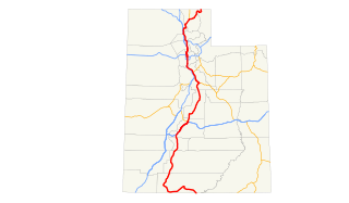
U.S. Route 89 in the U.S. state of Utah is a north–south United States Highway spanning more than 502 miles (807.891 km) through the central part of the state, making it the longest road in Utah. Between Provo and Brigham City, US-89 serves as a local road, paralleling Interstate 15, but the portions from Arizona north to Provo and Brigham City northeast to Wyoming serve separate corridors. The former provides access to several national parks and Arizona, and the latter connects I-15 with Logan, the state's only Metropolitan Statistical Area not on the Interstate.
The Snake River Range is located in the U.S. states of Wyoming and Idaho and includes 10 mountains over 9,000 feet (2,700 m). The tallest peak in the range is Mount Baird at 10,030 feet (3,060 m). The range trends northwest to southeast and is bordered on the north by the Teton Range and the two ranges meet at Teton Pass. The Snake River Range is bordered by the Palisades Reservoir to the west and the Snake River, which sweeps completely around the eastern, southern and western part of the range. The range is approximate 30 miles (48 km) north to south and 33 miles (53 km) west to east, covering 528 square miles (1,370 km2). Along the southern boundary, the Snake River passes through Grand Canyon, also known as the Snake River Canyon. U.S. Route 26/U.S. Route 89 follows the course of the Snake River from Hoback Junction to the Palisades Reservoir.
State Highway 67 (SH-67) is a state highway in Elmore County, Idaho. It connects the Mountain Home Air Force Base to SH-51 in the city of Mountain Home.
The following television stations broadcast on Digital television digital channel 7 in the United States:
The following television stations broadcast on digital channel 11 in the United States:
The following television stations broadcast on digital channel 12 in the United States:
The following television stations operate on virtual channel 8 in the United States:

The Fred Hottes House in Boise, Idaho, is a 2-story, sandstone and shingle Colonial Revival house designed by Tourtellotte & Co. and constructed in 1908. The house features a cross facade porch and a prominent, pedimented front gable. The house was added to the National Register of Historic Places in 1982.


