
Chamblee is a city in northern DeKalb County, Georgia, United States, northeast of Atlanta. The population was 30,164 as of the 2020 census.

North Bethesda is an unincorporated, census-designated place (CDP) in Montgomery County, Maryland, United States, located just north-west of the U.S. capital of Washington, D.C. It had a population of 50,094 as of the 2020 census. Among its neighborhoods, the centrally-located, urbanizing district of White Flint is the commercial and residential hub of North Bethesda. The Pike & Rose development and the Pike District is an initiative of Montgomery County to brand and market this region as "North Bethesda's Urban Core". The WMATA North Bethesda metro station and Grosvenor-Strathmore metro station serve the region.

Forest Hills is a city in Davidson County, Tennessee. The population was 5,038 at the 2020 census and 4,866 in a 2018 estimate.

Brentwood is a city in Williamson County, Tennessee, United States. The population was 45,373 as of the 2020 United States census. It is a suburb of Nashville and included in the Nashville metropolitan area.
Antioch is a neighborhood of Nashville located approximately 12 miles (19 km) southeast of Downtown Nashville. It is served by the Metropolitan Government of Nashville and Davidson County.

Bellevue is a neighborhood of Nashville, situated about 13 miles southwest of the downtown area via Interstate 40. It is served by the Metropolitan Government of Nashville and Davidson County. The 2016 population estimate for Bellevue's two main zip codes was 77,862.

Madison is a former settlement, now a suburban neighborhood of northeast Nashville, in the U.S. state of Tennessee. It is incorporated as part of the Metropolitan Government of Nashville and Davidson County.

Donelson is a neighborhood of Nashville, Tennessee, about 6 mi east of downtown Nashville along U.S. Route 70. It is named in honor of John Donelson, co-founder of Nashville and father-in-law of Andrew Jackson, Nashvillian and seventh President of the United States. Donelson is governed by the Metropolitan Council of Nashville and Davidson County, due to the fact that the government of Davidson County is consolidated with that of Nashville.
Whitehaven, informally known as "Blackhaven", is a predominantly African-American community in Memphis, Tennessee, United States. It was first organized in the late 19th century as a neighborhood for upper-class white families. Its current population is about 50,000.
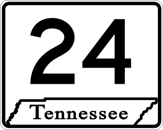
State Route 24 is an unsigned west–east state highway in Tennessee, as it coincides with U.S. Route 70 and U.S. Route 70N for its entire duration from Nashville to Crossville. The road begins in western Nashville and ends in Crossville. It runs alongside Interstate 40 for its entire length.
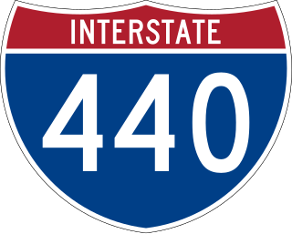
Interstate 440 (I-440) is an east–west auxiliary Interstate Highway that runs through Nashville, Tennessee. It serves as a southern bypass around downtown Nashville, and is located on average about three miles (4.8 km) from the center of the city. I-440 is also known locally as the Four-Forty Parkway, and is designated as the Debra K. Johnson Memorial Parkway. At a length of 7.64 miles (12.30 km), I-440 runs between I-40 and I-24, and connects to I-65 and multiple U.S. Routes. Combined, I-440 and Briley Parkway, a controlled-access segment of State Route 155 (SR 155), form a noncontiguous inner beltway around downtown Nashville.

Raleigh is a community in north-central Memphis, Tennessee, United States, named for a formerly incorporated town that used to be at its center. Raleigh is bordered on the west by the community of Frayser, on the east by the incorporated suburb of Bartlett, on the south by the Wolf River and Interstate 40, and on the north by the Memphis city limits. The former town of Raleigh was the first county seat of Shelby County, Tennessee.

Tanasbourne, Oregon, is a neighborhood in Washington County, Oregon, where NW 185th Avenue and the Sunset Highway intersect. It is located within the greater Portland metropolitan area. The area includes portions of Beaverton and Hillsboro, and is generally considered to be south of U.S. 26, north of Walker Road, west of 158th, and east of Cornelius Pass Road. Adjacent to Aloha and part of the West Metro region, Tanasbourne has many shopping areas and is the former home of the defunct Tanasbourne Mall.
WeGo Public Transit is a public transportation agency based in Nashville, Tennessee. Consisting of city buses and paratransit, the system serves Nashville and Davidson County. In 2023, the system had a ridership of 7,634,900, or about 28,900 per weekday as of the third quarter of 2024. For 2023, WeGo expected to collect $5.2 million in fare revenue and spend $99.3 million in operation. To make up most of the difference, WeGo expected to collect subsidies from the city, state, and national governments.

The Mall at Green Hills, originally Green Hills Village, is a shopping mall located in Nashville, Tennessee, United States. The mall has more than 100 stores and restaurants on two main floors totaling 1,053,000 square feet (97,800 m2). Nordstrom, Dillard's, and Macy's are the anchor stores. The mall is owned and managed by Taubman Centers.
Hillsboro Village is a neighborhood of Nashville, Tennessee, located 3 miles southwest of downtown. Hillsboro Village is governed by the Metropolitan Council of Nashville and Davidson County, due to the fact that the government of Davidson County is consolidated with that of Nashville.

Kingston Pike is a highway in Knox County, Tennessee, United States, that connects Downtown Knoxville with West Knoxville, Farragut, and other communities in the western part of the county. The road follows a merged stretch of U.S. Route 11 (US 11) and US 70. From its initial construction in the 1790s until the development of the Interstate Highway System in the 1960s, Kingston Pike was the main traffic artery in western Knox County, and an important section of several cross-country highways. The road is now a major commercial corridor, containing hundreds of stores, restaurants, and other retail establishments.
Hillsboro High School is a comprehensive high school in Nashville, Tennessee. Established in 1939, the school is one of fifteen high schools in Metropolitan Nashville Public Schools. The school offers the IB Diploma Programme.
West Knoxville is a section of Knoxville, Tennessee, US. It is west of the city's downtown area. It stretches from Sequoyah Hills on the east to the city's border with Farragut on the west. West Knoxville is concentrated around Kingston Pike (US-70/US-11), and along with Sequoyah Hills includes the neighborhoods of Lyons View, Forest Hills, Bearden, West Hills, Westmoreland Heights, Cedar Bluff, and Ebenezer.
West Meade is a neighborhood in Nashville, Tennessee. It is governed by the Metropolitan Council of Nashville and Davidson County, due to the fact that the government of Davidson County is consolidated with that of Nashville


