
Hathersage is a village and civil parish in the Peak District in Derbyshire, England. It lies slightly to the north of the River Derwent, approximately 10 miles (16.1 km) south-west of Sheffield.

Barton-upon-Humber or Barton is a town and civil parish in North Lincolnshire, England. The population at the 2011 census was 11,066. It is situated on the south bank of the Humber Estuary at the southern end of the Humber Bridge. It is 6 miles (10 km) south-west of Kingston upon Hull and 31 miles (50 km) north north-east of the county town of Lincoln. Other nearby towns include Scunthorpe to the south-west and Grimsby to the south-east.
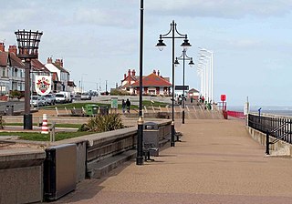
Hornsea is a seaside town and civil parish in the East Riding of Yorkshire, England. The settlement dates to at least the early medieval period. The town was expanded in the Victorian era with the coming of the Hull and Hornsea Railway in 1864. In the First World War the Mere was briefly the site of RNAS Hornsea Mere, a seaplane base. During the Second World War the town and beach was heavily fortified against invasion.

Ancaster is a village and civil parish in the South Kesteven district of Lincolnshire, England, on the site of a Roman town. The population of the civil parish was 1,317 at the 2001 census increasing to 1,647 at the 2011 census. The civil parish includes the settlements of Sudbrook and West Willoughby.

Caistor is a town and civil parish in the West Lindsey district of Lincolnshire, England. As its name implies, it was originally a Roman castrum or fortress. It lies at the north-west edge of the Lincolnshire Wolds, on the Viking Way, and just off the A46 between Lincoln and Grimsby, at the A46, A1084, A1173 and B1225 junction. It has a population of 2,601. Its name comes from the Anglo-Saxon ceaster and was given in the Domesday Book as Castre.
Burghfield is a village and large civil parish in West Berkshire, England, with a boundary with Reading. Burghfield can trace its history back to before the Domesday book, and was once home to three manors: Burghfield Regis, Burghfield Abbas and Sheffield. Since the 1980s the population of Burghfield has nearly doubled with the construction of many new housing estates, making it a dormitory for Reading, Newbury, Basingstoke and the M4 corridor which crosses the north of the parish.

Grosmont is a village and civil parish situated in Eskdale in the North York Moors National Park, within the boundaries of the Scarborough district of the county of North Yorkshire, England.

Harty is a small hamlet on the Isle of Sheppey in Kent consisting of a few cottages, a church and a public house, the Ferry Inn. It is part of the civil parish of Leysdown.

Withypool is a small village and former civil parish, now in the parish of Withypool and Hawkridge, in the Somerset district, in the ceremonial county of Somerset, England, near the centre of Exmoor National Park and close to the border with Devon. The word Withy means "willow". The parish of Withypool and Hawkridge, covers 3,097 hectares, includes the village of Hawkridge and has a population around 201.

Keyingham is a village and civil parish in the East Riding of Yorkshire, England. The village is situated approximately 10 miles (16 km) east of Kingston upon Hull city centre and lies on the A1033 road.

Piercebridge Roman Fort is a scheduled ancient monument situated in the village of Piercebridge on the banks of the River Tees in modern-day County Durham, England. There were Romans here from about AD 70 until at least the early 5th century. There was an associated vicus and bath house at Piercebridge, and another vicus and a villa south of the river at Cliffe. The Victorians used carved stones from this site when they built St Mary's church at Gainford. Part of the site is under Piercebridge village green.

Piercebridge Roman Bridge is the ruin of a Roman bridge over the River Tees, northern England. It is near the villages of Cliffe and Piercebridge, County Durham.

Cliviger is a civil parish in the Borough of Burnley, in Lancashire, England. It is situated to the southeast of Burnley, and northwest of Todmorden. According to the 2011 census, the parish has a population of 2,238.

Beck Hole is a small valley village in the Borough of Scarborough, North Yorkshire, England. The village lies within the Goathland civil parish and the North York Moors national park.

There are 37 scheduled monuments in Greater Manchester, a metropolitan county in North West England. In the United Kingdom, a scheduled monument is a "nationally important" archaeological site or historic building that has been given protection against unauthorised change by being placed on a list by the Secretary of State for Digital Culture, Media and Sport; Historic England recommends sites for scheduling to the Secretary of State. Scheduled monuments are defined in the Ancient Monuments and Archaeological Areas Act 1979 and the National Heritage Act 1983. There are nearly 20,000 entries on the schedule, which is maintained by Historic England as part of the National Heritage List for England; more than one site can be included in a single entry. While a scheduled monument can also be recognised as a listed building, Historic England's aim is to set the most appropriate form of protection in place for the building or site. Applications to deschedule a site are administered Historic England, who will carry out an assessment and make a recommendation to the Secretary of State.

Horbling is a village and civil parish in the South Kesteven district of Lincolnshire, England. It lies on the B1177, 7 miles (11 km) south-east of Sleaford, 14.5 miles (23 km) north-east of Grantham and 0.5 miles (0.8 km) north of Billingborough.

Cliffe is a small village and civil parish in North Yorkshire, England. It was historically part of the East Riding of Yorkshire until 1974, but from 1974 to 2023 was in the Selby District of the shire county of North Yorkshire. In 2023 the district was abolished and North Yorkshire became a unitary authority.

Milefortlet 11 was a Milefortlet of the Roman Cumbrian Coast defences. These milefortlets and intervening stone watchtowers extended from the western end of Hadrian's Wall, along the Cumbrian coast and were linked by a wooden palisade. They were contemporary with defensive structures on Hadrian's Wall. Milefortlet 11 has never been accurately located on the ground although other Roman remains have been found in the area.

Rokeby is a civil parish about 2.5 miles from Barnard Castle, in the County Durham district, in the ceremonial county of Durham, England. The parish includes the hamlet of Greta Bridge. In 2011 the parish had a population of 158. The parish touches Barningham, Boldron, Bowes, Brignall, Egglestone Abbey, Westwick, Whorlton and Wycliffe with Thorpe. The A66 runs through the area. Rokeby shares a parish council with Brignall and Egglestone Abbey called "Rokeby, Brignall & Egglestone Abbey Parish Council".


