
San Anselmo is an incorporated town in Marin County, California, United States. San Anselmo is located 1.5 miles (2.4 km) west of San Rafael, at an elevation of 46 feet. It is located about 20 miles (32 km) north of San Francisco. The town is bordered by San Rafael to the east, Fairfax to the west, and Ross to the south. Mount Tamalpais dominates the view to the south. The population was 12,336 at the 2010 census.

Lucas Valley-Marinwood is a census-designated place (CDP) in Marin County, California, United States. It includes the neighborhoods of Lucas Valley and Marinwood. As of the 2010 census, the population was 6,094.

San Rafael is an affluent city and the county seat of Marin County, California, United States. The city is located in the North Bay region of the San Francisco Bay Area. As of the 2010 census the city's population is 57,713.

Cabo San Lucas, or simply Cabo, is a resort city at the southern tip of the Baja California Peninsula, in the Mexican state of Baja California Sur. As of 2015, the population of the city was 81,111 inhabitants. Cabo San Lucas together with San José del Cabo is known as Los Cabos. Together they form a metropolitan area of 305,983 inhabitants.
Lucas Valley is a valley in Marin County, California, drained to the east into San Pablo Bay by Miller Creek, as well as an unincorporated community in the valley, which forms part of the Lucas Valley-Marinwood CDP.

Los Cabos is a municipality located at the southern tip of Mexico's Baja California Peninsula, in the state of Baja California Sur. It encompasses the two towns of Cabo San Lucas and San José del Cabo linked by a twenty-mile Resort Corridor of beach-front properties and championship golf courses. The area was remote and rural until the latter 20th century, when the Mexican government began to develop Cabo San Lucas for tourism, which then spread east to the municipal seat. The main draw is the climate and geography, where desert meets the sea, along with sport fishing, resorts and golf. This tourism is by far the main economic activity with over two million visitors per year. Over 1 million visit from the United States.

Federal Highway 1 is a free (libre) part of the federal highway corridors of Mexico, and the highway follows the length of the Baja California Peninsula from Tijuana, Baja California, in the north to Cabo San Lucas, Baja California Sur, in the south. The road connects with Via Rapida, which merges into the American Interstate 5 (I-5) at the international border south of San Ysidro, California.
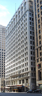
The Ford Building is a high-rise office building located at 615 Griswold Street in Downtown Detroit, Michigan. It stands at the northwest corner of Congress and Griswold Streets, in the heart of Detroit's Financial District. The Penobscot Building abuts the building to the north, and the Guardian Building is southeast across Griswold Street.
Federal Highway 19 is a free part of the federal highways corridors and runs along the Pacific coast of Baja California Peninsula from Cabo San Lucas up to Todos Santos where it turns inland and eventually joins Fed. 1 a few miles south of San Pedro, Baja California Sur.
The 1960 NCAA University Division Basketball Tournament involved 25 schools playing in single-elimination play to determine the national champion of men's NCAA Division I college basketball in the United States. It began on March 7, 1960, and ended with the championship game on March 19 in Daly City, California. A total of 29 games were played, including a third place game in each region and a national third place game.

The Microstigmatidae are a small family of spiders with 17 described species in seven genera. They are small ground-dwelling and free-living spiders that make little use of silk.

USS Griswold (DE-7) was an Evarts-class short-hull destroyer escort in the service of the United States Navy, named for Ensign Don T. Griswold, who perished during the battle of Midway 1942.

Las Gallinas is an unincorporated community in Marin County, California, 6.25 miles (10.06 km) south-southeast of Novato. At an elevation of 26 feet Las Gallinas is near the interchange of U.S. Route 101 and Lucas Valley Road/Smith Ranch Road in San Rafael.

The Griswold Hills are a low mountain range in the Southern Inner California Coast Ranges System, in southeastern San Benito County, central California.

Docas is a former settlement in Monterey County, California. It was located on the Southern Pacific Railroad 5 miles (8 km) north-northwest of San Ardo, at an elevation of 404 feet. It still appeared on USGS maps as of 1943.
Upland is a former settlement in Monterey County, California. It was located on the Southern Pacific Railroad less than half the distance from San Lucas to San Ardo.
Rita Sanchez is an American academic in the field of Chicana/o studies.
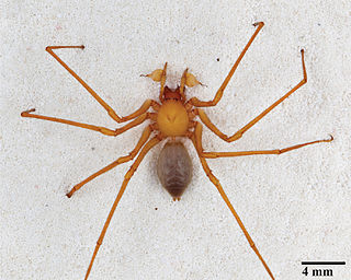
Trogloraptor is a genus of large spiders found in the caves of southwestern Oregon. It is the sole genus in the family Trogloraptoridae, and includes only one species, Trogloraptor marchingtoni. These spiders are predominantly yellow-brown in color with a maximum leg span of 3 in (7.6 cm). They are remarkable for having hook-like claws on the raptorial last segments of their legs.
Griswold Creek is a stream in San Benito County, California. Its head is at the confluence of Pimental Creek and Vallecitos Creek. From there it flows north-northeastward through the canyon between the Griswold Hills in the east, and Buck Peak in the Diablo Range on the west, to its mouth, located at an elevation of 1,145 feet (349 m) at its confluence with Panoche Creek 1.5 miles (2.4 km) southeast of Panoche in the Panoche Valley.


