
The Green River is a 384-mile-long (618 km) tributary of the Ohio River that rises in Lincoln County in south central Kentucky. Tributaries of the Green River include the Barren River, the Nolin River, the Pond River and the Rough River. The river was named after Nathanael Greene, a general of the American Revolutionary War.

The Cumberland River is a major waterway of the Southern United States. The 688-mile-long (1,107 km) river drains almost 18,000 square miles (47,000 km2) of southern Kentucky and north-central Tennessee. The river flows generally west from a source in the Appalachian Mountains to its confluence with the Ohio River near Paducah, Kentucky, and the mouth of the Tennessee River. Major tributaries include the Obey, Caney Fork, Stones, and Red Rivers.

Lake Cumberland is a reservoir in Clinton, Pulaski, Russell, Wayne, and Laurel, counties in Kentucky. The primary reasons for its construction were a means for flood control and the production of hydroelectric power. Its shoreline measures 1,255 miles (2,020 km) and the lake covers 65,530 acres (265 km2) at the maximum power pool elevation. The reservoir ranks 9th in the U.S. in size, with a capacity of 6,100,000 acre-feet (7.5 km3) of water, enough to cover the entire Commonwealth of Kentucky with 3 inches (76 mm) of water. The main lake is 101 miles (163 km) long and over one mile (1.6 km) across at its widest point.

Lake Barkley, a 58,000-acre (230 km2) reservoir in Livingston County, Lyon County and Trigg County in Kentucky and extending into Stewart County and Houston County in Tennessee, was impounded by the U.S. Army Corps of Engineers in 1966 upon the completion of Barkley Dam. Both the lake and the dam are named for Vice President Alben Barkley, a Kentucky native.
Buckhorn Lake, located south of Buckhorn, Kentucky, United States and northwest of Hazard, Kentucky off Kentucky Route 28, is a 1,230-acre (5 km2) reservoir created by the United States Army Corps of Engineers in 1967 by impounding the Middle Fork of the Kentucky River. The lake was flooded over top of a small township called Bowlingtown.

Carr Creek Lake, located east of Hazard, Kentucky, along Kentucky Route 15 in Knott County, is a 710 acres (3 km2) reservoir created by the U.S. Army Corps of Engineers in 1976. Carr Creek Lake's earth and rock fill dam is 130 ft (40 m) tall and 720 ft (219 m) long, and the dam is located 8.8 mi (14 km) above the mouth of Carr Fork River, a tributary of the North Fork Kentucky River.

Kentucky Lake is a major navigable reservoir along the Tennessee River in Kentucky and Tennessee. It was created in 1944 by the Tennessee Valley Authority's impounding of the Tennessee River via Kentucky Dam for flood control and hydroelectric power. The 160,309-acre (649 km2) lake is the largest artificial lake by surface area in the United States east of the Mississippi River, with 2,064 miles (3,322 km) of shoreline. Kentucky Lake has a flood storage capacity of 4,008,000 acre⋅ft (4.944 km3), more than 2.5 times the next largest lake in the TVA system.

Kentucky Dam is a hydroelectric dam on the Tennessee River on the county line between Livingston and Marshall counties in the U.S. state of Kentucky. The dam is the lowermost of nine dams on the river owned and operated by the Tennessee Valley Authority, which built the dam in the late 1930s and early 1940s to improve navigation on the lower part of the river and reduce flooding on the lower Ohio and Mississippi rivers. It was a major project initiated during the New Deal of President Franklin D. Roosevelt's administration, to invest in infrastructure to benefit the country. The dam impounds the Kentucky Lake of 160,000 acres (65,000 ha), which is the largest of TVA's reservoirs and the largest artificial lake by area in the Eastern United States. It was designated as an National Historic Civil Engineering Landmark by the American Society of Civil Engineers in 1996 and listed on the National Register of Historic Places in 2017.

Dewey Lake, located near Prestonsburg, Kentucky in Floyd County, is part of the integrated flood reduction system operated by the United States Army Corps of Engineers for the entire Ohio River Basin.
Laurel River Lake, located west of Corbin, Kentucky, in the U.S., is a reservoir built in 1977 by the U.S. Army Corps of Engineers on the Laurel River, a tributary of the Cumberland River, in the Daniel Boone National Forest. The lake covers parts of Laurel and Whitley counties.
Fishtrap Lake is a 1,130-acre (5 km2) reservoir in Pike County, Kentucky. Dedicated by President Lyndon B. Johnson in 1968, the lake was formed by the impounding of the Levisa Fork of the Big Sandy River at the 195-foot-high Fishtrap Dam by the United States Army Corps of Engineers.

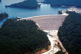
Grayson Lake is a 1,500-acre (6.1 km2) reservoir in Carter and Elliott counties in Kentucky. It was created by the United States Army Corps of Engineers in 1968 by impounding the Little Sandy River with the Grayson Dam, an earthen structure 120 feet high, creating a maximum capacity of 118,990 acre-feet. Sections of Kentucky Route 7 were re-routed as a result of the lake's creation. KY 7 now traverses a modern highway stretch around the park, crossing the dam also.
Herrington Lake is a 2,335-acre (9 km2) artificial lake located in Mercer, Garrard and Boyle counties in Kentucky, United States. The lake was created by Kentucky Utilities' damming of the Dix River, a tributary of the Kentucky River, in 1925 to generate hydroelectric power. With a maximum depth of 249 feet (76 m), Herrington Lake is the deepest lake in Kentucky. A short distance below the dam, the Dix River enters the Kentucky River at High Bridge, Kentucky.
Rough River Dam State Resort Park is a Kentucky state park encompassing 637 acres (258 ha) on Rough River Lake in Grayson county.
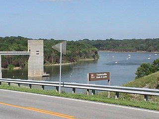
Taylorsville Lake State Park is a park encompassing 1,200 acres (490 ha) in Spencer County, Kentucky, roughly midway between Louisville and Lexington. Taylorsville Lake, its major feature, extends into parts of Anderson County and Nelson County.

Paintsville Lake is a 1,139-acre (4.61 km2) reservoir in Johnson and Morgan counties in eastern Kentucky. It was impounded from Paint Creek in 1983 by the United States Army Corps of Engineers. It is the major attraction of Paintsville Lake State Park.

Land Between the Lakes National Recreation Area is a United States 171,280 acres (69,310 ha) national recreation area in Kentucky and Tennessee between Lake Barkley and Kentucky Lake. It was designated as a national recreation area in 1963 by President John F. Kennedy and developed using funds appropriated during the Johnson administration.


