
Kentucky, officially the Commonwealth of Kentucky, is a state in the Southeastern region of the United States and one of the states of the Upper South. It borders Illinois, Indiana, and Ohio to the north, West Virginia to the northeast, Virginia to the east, Tennessee to the south, and Missouri to the west. Its northern border is defined by the Ohio River. Its capital is Frankfort, and its largest city is Louisville. Its population was approximately 4.5 million in 2020.

Frankfort is the capital city of the Commonwealth of Kentucky, United States, and the seat of Franklin County. It is a home rule-class city; the population was 28,602 at the 2020 census. Located along the Kentucky River, Frankfort is the principal city of the Frankfort, Kentucky Micropolitan Statistical Area, which includes all of Franklin and Anderson counties.
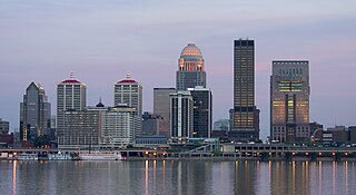
Louisville is the largest city in the Commonwealth of Kentucky, sixth-most populous city in the Southeast, and the 28th most-populous city in the United States. Louisville is the historical seat and, since 2003, the nominal seat of Jefferson County, on the Indiana border.

McLean County is a county located in the U.S. state of Kentucky. As of the 2020 census, the population was 9,152. Its county seat is Calhoun and its largest city is Livermore. McLean is a prohibition or dry county. McLean County is part of the Owensboro, KY Metropolitan Statistical Area, which has a population of some 114,752.

Barren County is a county located in the south-central portion of the U.S. state of Kentucky. As of the 2020 census, the population was 44,485. Its county seat is Glasgow. The county was founded on December 20, 1798, from parts of Warren and Green Counties. It was named for the Barrens, meadowlands that cover the northern third, though actually the soil is fertile. Barren County is part of the Glasgow, KY Micropolitan Statistical Area, which is also included in the Bowling Green-Glasgow, KY Combined Statistical Area. In 2007 Barren County was named the "Best Place to Live in Rural America" by Progressive Farmer Magazine.

Owensboro is a home rule-class city in and the county seat of Daviess County, Kentucky, United States. It is the fourth-largest city in the state by population. Owensboro is located on U.S. Route 60 and Interstate 165 about 107 miles (172 km) southwest of Louisville, and is the principal city of the Owensboro metropolitan area. The 2020 census had its population at 60,183. The metropolitan population was estimated at 116,506. The metropolitan area is the sixth largest in the state as of 2018, and the seventh largest population center in the state when including micropolitan areas.

Pineville is a home rule-class city in Bell County, Kentucky, United States. It is the seat of its county. The population was 1,732 as of the 2010 census. It is located on a small strip of land between the Cumberland River and Pine Mountain.

Ashland is a home rule-class city in Boyd County, Kentucky, United States. The largest city in Boyd County, Ashland is located upon a southern bank of the Ohio River at the state border with Ohio and near West Virginia. The population was 21,625 at the 2020 census. Ashland is a principal city of the Huntington–Ashland metropolitan area, referred to locally as the "Tri-State area", home to 359,862 residents as of 2020. Ashland serves as an important economic and medical center for northeastern Kentucky.

Greenup is a home rule-class city located at the confluence of the Little Sandy River with the Ohio River in Greenup County, Kentucky, United States. The population was 1,188 at the 2010 census. Greenup is one of three county seats in the Commonwealth of Kentucky to share its name with its county; the other two being Harlan and Henderson.

Elizabethtown is a home rule-class city and the county seat of Hardin County, Kentucky, United States. The population was 28,531 at the 2010 census, and was estimated at 30,289 by the U.S. Census Bureau in 2019, making it the 11th-largest city in the state. It is included in the Elizabethtown–Fort Knox, Kentucky Metropolitan Statistical Area, which is included in the Louisville/Jefferson County–Elizabethtown–Madison, Kentucky-Indiana Combined Statistical Area. The Elizabethtown Metropolitan area had a 2019 estimated population of 153,057, making it the 5th largest metropolitan area in the state.

Richmond is a home rule-class city in and the county seat of Madison County, Kentucky, United States. It is named after Richmond, Virginia, and is home to Eastern Kentucky University. The population was 34,585 at the 2020 census. Richmond is the fourth-largest city in the Bluegrass region and the state's seventh-largest city. It is the ninth largest population center in the state with a Micropolitan population of 106,864. The city serves as the center for work and shopping for south-central Kentucky. In addition, Richmond is the principal city of the Richmond-Berea, Kentucky Micropolitan Area, which includes all of Madison and Rockcastle counties.
Pikeville is a city in and the county seat of Pike County, Kentucky, United States. During the 2020 U.S. Census, the population within Pikeville's city limits was 7,754. In Kentucky's current city classification system, Pikeville is a home rule-class city, a category that includes all of the state's more than 400 cities except for the two largest, Louisville and Lexington.
Bowling Green is a home rule-class city and the county seat of Warren County, Kentucky, United States. Founded by pioneers in 1798, Bowling Green was the provisional capital of Confederate Kentucky during the American Civil War. As of the 2020 census, its population of 72,294 made it the third-most-populous city in the state, after Louisville and Lexington; its metropolitan area, which is the fourth largest in the state after Louisville, Lexington, and Northern Kentucky, had an estimated population of 179,240; and the combined statistical area it shares with Glasgow has an estimated population of 233,560.

The Cumberland River is a major waterway of the Southern United States. The 688-mile-long (1,107 km) river drains almost 18,000 square miles (47,000 km2) of southern Kentucky and north-central Tennessee. The river flows generally west from a source in the Appalachian Mountains to its confluence with the Ohio River near Paducah, Kentucky, and the mouth of the Tennessee River. Major tributaries include the Obey, Caney Fork, Stones, and Red rivers.

The Cumberland Mountains are a mountain range in the southeastern section of the Appalachian Mountains. They are located in western Virginia, southwestern West Virginia, the eastern edges of Kentucky, and eastern middle Tennessee, including the Crab Orchard Mountains. Their highest peak, with an elevation of 4,223 feet (1,287 m) above mean sea level, is High Knob, which is located near Norton, Virginia.

Kroger Field, formerly known as Commonwealth Stadium, is a stadium in Lexington, Kentucky, United States, located on the campus of the University of Kentucky that primarily serves as the home field for the Kentucky Wildcats football team. The stadium is located at the corner of Alumni Drive and University Drive in Lexington. The playing surface is named C.M. Newton Grounds in honor of retired UK athletic director and former baseball and basketball player C.M. Newton. Built in 1973, it is the newest football stadium in the Southeastern Conference, as measured by date of original construction. The original capacity for the stadium was 57,800. In the stadium's first game, played on September 15, 1973, the Wildcats defeated the Virginia Tech Hokies 31–26.

The University of Pikeville (UPIKE) is a private university affiliated with the Presbyterian Church (USA) and located in Pikeville, Kentucky. It was founded in 1889 by the Presbyterian Church and is located on a 25-acre (10 ha) campus on a hillside overlooking downtown Pikeville.
Commonwealth is a term used by four of the 50 states of the United States in their full official state names. "Commonwealth" is a traditional English term used to describe a political community as having been founded for the common good. The four states – Kentucky, Massachusetts, Pennsylvania, and Virginia – are all in the Eastern United States, and prior to the formation of the United States in 1776 were British colonial possessions. As such, they share a strong influence of English common law in some of their laws and institutions. However, the "commonwealth" appellation has no legal or political significance, and it does not make "commonwealth" states any different from other U.S. states.

The Defense of Cincinnati occurred during what is now referred to as the Confederate Heartland Offensive or Kentucky Campaign of the American Civil War, from September 1 through September 13, 1862. Confederate Brigadier General Henry Heth was sent north from Lexington, Kentucky, to threaten Cincinnati, Ohio, then the sixth-largest city in the United States. Heth was under orders from his superior, Major General Edmund Kirby Smith, not to attack the city, but to instead make a "demonstration". Once Heth arrived and reconoitered the defenses, he realized an attack was pointless. After a few minor skirmishes, he took his men back to Lexington.

The Ohio River Islands National Wildlife Refuge (ORINWR) is a National Wildlife Refuge (NWR) in non-contiguous sites consisting of islands along 362 miles (583 km) of the Ohio River, primarily in the U.S. state of West Virginia.


