Glenville, Kentucky | |
|---|---|
| Nickname: Lickskillet | |
 Glenville  Glenville | |
| Coordinates: 37°35′40″N87°11′36″W / 37.59444°N 87.19333°W | |
| Country | United States |
| State | Kentucky |
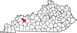
| County | McLean |
| Elevation | 443 ft (135 m) |
| Time zone | UTC-6 (Central (CST)) |
| • Summer (DST) | UTC-5 (CDT) |
| Census code | 31438 |
| GNIS feature ID | 508101 [1] |
Glenville (also Lickskillet) is an unincorporated community in McLean County, Kentucky, United States. [2]